Wednesday, December 26, 2018

LOWER SPRINGS


Above: a cabin at Lower Springs. This photograph was taken in 1900. Courtesy of Shasta Historical Society.

After the first two gold discoveries in California were confirmed to be true, scores of people descended into California from around the world, and onto the Rancho Buena Ventura in 1849. As Gold Rush pandemonium struck this region and populated places near it, the forty-niners began pitching up their tents at a rapid pace. These people made their camp sites about two miles southeast of Reading Springs. After that, they began to prospect the nearby creek channels to stake out their placer mining claims. Not everyone was successful at mining. 

At this location, a tent community called Lower Springs was established by these forty-niners, that year. Lower Springs became one of the original gold rush communities of Shasta County. This new tent community was named Lower Springs because its name derived from the nearby community of Reading Springs. Later on, the name of Reading Springs was changed to Shasta on June 8, 1850, and the community of Lower Springs kept its name.

A man by the name of Benjamin Swasey was among the first settlers of this flourishing mining community. He was a native of New Hampshire and he arrived in Shasta County in 1849. After his arrival, the Lower Springs mining district formed its boundaries in the area. Some people made their fortune while others weren't as lucky, yet these miners kept locating new placer mines in this mining district. During the summer months, the Lower Springs mining district became dry diggings with the lack of rain, and water resources were unavailable for miners to use in their placer mines at that time.

Eventually, the rain fell and restored the water in the creek channels every year, as early as fall or as late as winter, however; summer rain storms were known to happen.  It was Swasey who purportedly owned some land near Lower Springs at Gold Gulch. Gold Gulch was a tributary of Salt Creek which reportedly yielded him, $1,500 to the cubic yard in gold. Salt Creek was another stream which channeled near Lower Springs.

In 1850, the first wooden home structure was erected at Lower Springs, and soon after, other homes were completed with additional bungalows and cabins. Lower Springs had a thriving population during its hey-day, the exact number of settlers weren't recorded. However, Lower Springs' population fueled this flourishing community to be a contender for the county seat of Shasta County, along with Horsetown and Shasta, in the running on the ballot at the local primary election in 1851. This is when the county seat was removed from the Reading Adobe at Cottonwood to Shasta.

Then on, March 6, 1851 the town of Shasta became the second county seat of Shasta County. The original location of Lower Springs was on the stage road which routed rigs from Canon House (Canyon House) to Shasta. The current site is located a quarter-mile west of the junction of Highway 299 and Ridge Drive.

The burgeoning community of Lower Springs was prone to Indian attack's, and the Indians raided many cabins in the area at that time, taking with them all of the supplies and provisions the early settlers owned. Then on, April 17, 1851, a man by the name of Merady Swan, a native of Missouri, was murdered by Indians in this community. The following article is from the Sacramento Transcript newspaper of Sacramento:

"Killed By Indians - A man named Merady Swan formerly of Missouri, was shot in his cabin at Lower Springs, two miles this side of Shasta City, one night last week. The Indians slipped up to his cabin at night and shot him through a crack in the door, while he was sitting at the table. Several other persons were in the house, which prevented them from robbing it." (SIC)

In May of 1852, the miners of this mining district were averaging five dollars to the pan per day on Salt Creek. A new settler to the area by the name of Jonathon F. Gage, a native of New Hampshire, erected a log style house there. Gage was married to Alice Jane Swasey a sister of Benjamin Swasey. Jonathon’s profession was farming but he also tried his hand at mining. Together they raised a large family, and then in 1866 they relocated from Lower Springs to Middletown, this is where Gage registered to vote that year.

In 1853, Benjamin Swasey filed a land claim at Shasta, for one hundred and sixty acres of land at Lower Springs, and then he erected a house on this property for him to live in. He also erected two additional buildings at Lower Springs for his businesses. Swasey became the proprietor of the Swasey hotel and the Swasey mercantile store. The hotel included a large barn and a corral with a natural spring of water. Hay and barley were also stocked in the hotel's barn. His business prospered as Swasey advertised in the Shasta Courier newspaper from Shasta. 


Above: an advertisement for Swasey's hotel at Lower Springs, the ad above is from the Saturday, January 21, 1854 edition of the Shasta Courier newspaper.


Above: this is an upper torso photograph of an elderly, Benjamin Swasey. Benjamin was born on January 31, 1822 in New Hampshire and he died in Oakland, Alameda County, California on September 19, 1912, at the age of ninety. He is buried at Redding in the Redding Memorial Park. He was married twice, first to Nellie Dalton, and second to, Emily Marshall. Then in 1861, Swasey became a photographer and relocated to San Francisco. This image was taken circa 1880s at Vance's Gallery in San Francisco. Courtesy of Shasta Historical Society.


Aside from the businesses owned by Benjamin Swasey, this community also included a boarding house called the Virginia House and a blacksmith shop which was owned and operated by Henry Jones. Jones was a native of Ohio, and he was married to his wife, Emily. There was at least one son produced during this union which they named James Jones. At a later date, Henry Jones changed his profession to become a gunsmith.

Then on, Saturday, April 2, 1853, the Shasta Courier newspaper reported the following information in the forthcoming article:

"DIGGINGS ABOUT LOWER SPRINGS - We have heard of remarkably good wages being made within the past few days in these diggings, and what is more, we know it to be true. Dr. Dunlap, in digging a cellar under his house, took the trouble to prospect the dirt, and found it paid upwards of two cents to the pan from the surface to the bed rock. This ground of course would pay fine wages for sluicing, if water was to be had." (SIC)

Later that month, additional excitement occurred at the placer mines on the hillside above the Virginia House, which yielded lucrative results to local miners. Miners also crossed the main stage road to the land opposite of the boarding house and they made the most gratifying success there. There were many delightful parties were held at the Swasey house where people danced the night away and during each ball a supper was prepared by Swasey’s wife, Nellie, to serve the guests. Anyone was welcome to join them and it was a great way for the lonely miners of the area to interact with the beautiful and single ladies.

The following year, the miners of the area were extremely harsh on the Chinese immigrants in the Lower Springs mining district, and at that time, they voted to ban all Chinese immigrants, and then, they forced them to turnover their mining properties to the miners of the area which were not of that race, and the "white miner" weren't the only race to enforce this policy. Hong Kong, near Shasta was closest Chinatown to Lower Springs, which was located two miles away. There were quite a number of anti-Chinese mining districts in Shasta County. Lower Springs wasn't the only mining district to evict the Chinese.


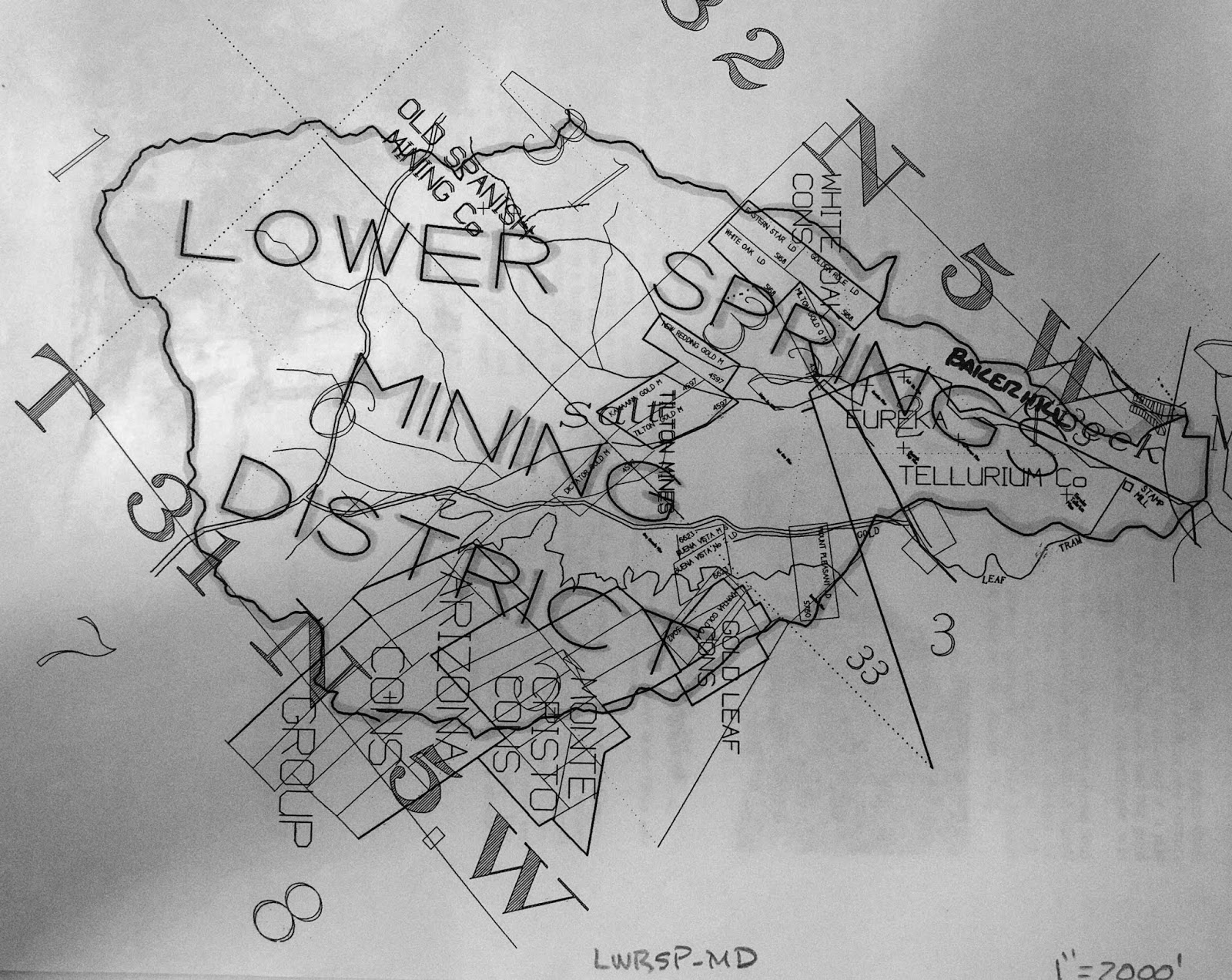
Above: This undated surveyed map shows the boundaries of the Lower Springs mining district and some of the mines included. Please note the name: the Old Spanish Mining Co., of course other mines and companies are noted on it as well. 

In the fall of 1854, a brand new trading post was established at Lower Springs by J.D. Dunlap & Company, and they began advertising their general merchandise store in the local media. Two months later, in December of that year, the first rain eventually fell, and miners had an abundance of water to use. The miners started washing their placer mines and they were making one hundred dollars per day by rocker at that time.


Above: an advertisement for J.D. Dunlap & Company at Lower Springs. This ad is from the Saturday, October 21, 1854 edition of the Shasta Courier newspaper.


The construction of the Clear Creek Ditch, sometimes referred to as the Clear Creek Canal, began in December of 1853. Local miners raised the money to back this large project to convey the water of Clear Creek into the nearby dry diggings of Briggsville, Horsetown, Lower Springs, Muletown, Shasta and Whiskeytown. The ditch connected with a large reservoir which was built as a major part of this project.

Local miners celebrated the ditches completion on November 24, 1855. The length of this ditch measured at sixty miles. The reservoir at Middletown covered fifteen acres to a depth of eight feet. Immediately, the water from this ditch began conveying water into the Lower Springs mining district at Salt Creek. The miners at Lower Springs now had an abundance of water to use in their mining claims.

There wasn't much of a ruckus at Lower Springs between the years 1856 and 1857; however, this community managed to stay relevant. The miners in the area focused on their placer mines, and local businesses advertised their companies in the local media. However, in July of 1857, Swasey’s hotel was still owned by Benjamin Swasey, but it was now under new management. A man by the name of Willam H. Bond was hired by Swasey to manage the hotel for him. Swasey still ran his mercantile store but his extra time was focused on being the public administrator of Shasta County, which is part of the reason he couldn’t manage both the mercantile store and the hotel by himself.


Above: an advertisement for the Administrator's Sale of Real Estate for the estate of T.B. Pritchett, deceased. This estate sale was held on Main Street at Texas Springs, in Shasta County, by Benjamin Swasey, Public Administrator on August 22, 1857. The above ad is from the Saturday, August 8, 1857 edition of the Shasta Courier newspaper.

Two years later, on February 19, 1859, the Shasta Courier newspaper heralded the following article:

Pottery - The manufacture of pottery has been fairly commenced by Messrs., Bly & Co., at Lower Springs. It is the first manufactory of the kind that we have heard of being established in the Northern part of the State. The first kiln was burned a few days ago. It was entirely successful and the ware is of excellent quality. We have been presented with a large pitcher from this first kiln and we value it highly. It argued well for California to witness the commencement of manufacturing establishments throughout the State - however, humble they may be in their inception. We wish Messrs., Bly and Co., an abundant reward in the pursuit of their laudible enterprise.” (SIC) 

Apparently, the above article by the Shasta Courier newspaper conflicts with previous statements by local historians who claimed that, a man by the surname of Tozure, had owned and operated the first pottery shop at Lower Springs. There's no information to suggest that Tozure was employed by Bly and Company, or that Tozure had become Bly and Company’s successor at Lower Springs. There might have been two different pottery shops at different era's in this community, in operation, because the above article suggest otherwise.

This quiet burg was interrupted one day, in January of 1863, by an affray started by Lawrence O' Connell who assaulted William Thompson over a bottle of strychnine whiskey. This is one incident that the local media frenzied over. It was Thompson who was severely beaten by O’ Connell that day, and after the violent dispute, O'Connell immediately departed Lower Springs for Latona. Thompson traveled to Shasta where he pressed charges of assault against his assailant at the Sheriff’s office. O’Connell was later arrested at Latona by Sheriff John S. Follansbee, and then, Follansbee escorted him to Shasta where he was jailed.

In June of 1863, Jones & Company struck a fine ledge of gold particles on their mining property at Lower Springs. They believed that this ore would carry a high value at the assayers office and it won them quite a bit of praise in the local media. The ledge was measured at twenty-two feet wide, immediately, Henry Jones and his crew sunk a shaft down twenty feet below the surface of the earth. 

As they continued to lower the shaft, the ore they sought after revealed better quality. This discovery brought a boom to the community of Lower Springs, and it became one of the first quartz mines in the Lower Springs mining district. Everything until then had been placer mining, in that area, Jones & Company would soon develop the property further with tunnels, drifts and upraises. Its believed that this former placer mine became the quartz mine known as the Old Spanish Mine.

After this quartz mine was dug out, a number of placer mining properties in the Lower Springs mining district were transformed by miners into quartz mines. In November of 1864, Henry Jones who was one of Lower Springs leading citizens was elected as Supervisor of District 1 of Shasta County, the local media referred to Jones as being “eminently qualified for the position”. That month, a number of large quantity of rocks from the Old Spanish Mine at Lower Springs was hauled to the Spring Creek stamp mill on Spring Creek to be crushed so they can obtain the gold from the quartz rocks.

Then on, Saturday, March 4, 1865, the Shasta Courier heralded the following account of a recent discovery made by Henry Jones: 

A SWEET DISCOVERY - Last week Mr. Jones, of Lower Springs observes s large number of honey bees working upon the willows in that vicinity, and being quite an expert apiarist, he noticed that in leaving the willows they generally flew in the same direction, and by taking observations from some willows in the vicinity of Mr. Wiser’s garden he saw that the course taken by the bees from the two points converged upon a hill about a half mile from Lower Springs, and upon going to the place, he found the bees occupying a log upon the hill. The log was opened and forty pounds of excellent honey taken therefrom and sufficient left for the bees, which Mr. Jones has taken to his house.” (SIC)

A man named Bert Wiser partnered with a another man by the surname of Terry and together they established an excellent vineyard at Lower Springs. Wiser & Terry were well-known purveyors of wine which became a locally renown favorite of the era. Their wine was bottled at their Lower Springs vineyard and then transported to Wiser’s home at Buckeye, in Shasta County. He lived on the Buckeye Ranch where Wiser & Terry kept a rather large cellar that they stored their wine in. Their wine was labeled as Wiser & Terry, Lower Springs, California.

Another serious affray occurred in this community on March 15, 1865, when a shooting of a Chinaman transpired over an apparent purchase of a mining claim and water ditch. The German settler who apparently sold the property to the Chinaman denied the fact that he had sold him the land. Then the German claimed that he didn't realize the area was an anti-Chinese district. After they quarreled- the German shot the Chinaman in the arm and the feud was settled according to reports, but both parties lived, and no one was arrested.

On September 9, 1865, the local media reported the following; 

"We are advised that there are fair prospects for the erection of a small mill at Lower Springs, this fall. - The good work goes on, and if the people will but prospect, the future of Shasta is assured." (SIC) 

The above quote by the Shasta Courier newspaper is referring to a brand new stamp mill to help crush the rock to obtain the ore from the samples they retrieved. The mining company to establish this new stamp mill at Lower Springs was the Union Company who hired a man by the name of L.A. Kelly to be their superintendent at the stamp mill and supervise their daily operations here. The Union Company's stamp mill wasn't in operation until mid-December. It's not known how many stamps this crusher had.

Between the years 1866 and 1870, there were newer quartz mines which were located in the Lower Springs mining district. The quartz rock from these mines were hauled to the Union Company's stamp mill or the Spring Creek stamp mill. The ore from these mines were assayed at high value, and due to this mining boom these lucrative quartz mines brought new settlers to the area. The Union Company actually began to dig and blast through surface rock to make their own quartz mine at their stamp mill property to prospect.

While the decade of the 1870s and 1880s evolved around the mining district at Lower Springs, the (old) gold mining burg flourished once again as work continued in number of mines in the area. One quartz mine in particular is the Old Spanish Mine, which is located in the Lower Springs mining district. Throughout history, this mining burg never established a post office, and it continued to be prominent into the 1890s, and past the turn of the 20th century. Today, Lower Springs Road retains the name of this once thriving gold rush community and present day Swasey Drive was named after forty-niner, Benjamin Swasey.


Above: In January of 1905, this plat map of the Telluride Consolidated Mine was surveyed by Alfred Baltzell, an U.S. Deputy Mineral Surveyor, for its owners Charles Piftschek, and Anton Herzlieb, of Redding. The Telluride Consolidated Mine embraced the Tellurium Quartz Mine, Diagonal Quartz Mining Claim, and the Hill Gravel and Quartz Mining Claim. All of these were located on the property of Piftschek and Herzlieb.


Legend has it that these iconic palm tree's were planted by pioneer, Benjamin Swasey at Lower Springs, and they grew in front of his Swasey hotel. The palm tree's lasted until the decade of the 1970s when the area was developed and they were uprooted. This photograph was taken in 1972. Courtesy of Shasta Historical Society.


RESOURCES:

1850 U.S. Census

Killed By Indians - The Sacramento Transcript newspaper of Sacramento, April 17, 1851

From The Interior - The Sacramento Daily Union newspaper of Sacramento, May 31, 1852

Lower Springs - The Shasta Courier newspaper of Shasta, March 12, 1853

Diggings About Lower Springs - The Shasta Courier newspaper of Shasta, April 2, 1853

The Lower Springs Road - The Shasta Courier newspaper of Shasta, May 7, 1853

The Ball At Lower Springs- The Shasta Courier newspaper of Shasta, January 21, 1854

J.D. Dunlap & Co. - The Shasta Courier newspaper of Shasta, October 21, 1854

Lower Springs - The Shasta Courier newspaper of Shasta, December 23, 1854

A Serious Difficulty - The Shasta Courier newspaper of Shasta, January 13, 1855

Convention of Shasta County Miners Relative to the Chinese Question - The Shasta Courier newspaper of Shasta, January 20, 1855

Clear Creek Ditch - The Sacramento Daily Union newspaper of Sacramento, October 29, 1855

Clear Creek Ditch Finished! - The Shasta Courier newspaper of Shasta, November 24, 1855

Swasey’s Hotel advertisement - The Shasta Courier newspaper of Shasta, July 11, 1857

Slanderous - The Shasta Courier newspaper of Shasta, February 19, 1859

1860 U.S. Census

Supervisor - The Shasta Courier newspaper of Shasta, November 19, 1864

Quartz - The Shasta Courier newspaper of Shasta, November 26, 1864

A Sweet Discovery - The Shasta Courier newspaper of Shasta, March 4, 1865

Shot - The Shasta Courier newspaper of Shasta, March 18, 1865

Still Another Mill - The Shasta Courier newspaper of Shasta, September 9, 1865

Lower Springs - Union Co. - The Shasta Courier newspaper of Shasta, December 9, 1865

New Discovery - The Shasta Courier newspaper of Shasta, January 6, 1866

Struck It - The Shasta Courier newspaper of Shasta, February 10, 1866

Prospecting Mill - The Shasta Courier newspaper of Shasta, March 10, 1866

Buckeye Ranch - The Shasta Courier newspaper of Shasta, April 1, 1865

1866 California Voters Registration

1870 U.S. Census

1880 U.S. Census

California Journal of Mines and Geology, Volume 10 1890, page 632.

Mining District Near Redding’s Limits - Mineral Wealth Magazine, March 15, 1905

Benjamin Swasey Dies At Home In Oakland - The San Francisco Call newspaper of San Francisco, September 20, 1912

My Playhouse Was A Concord Coach, an anthology of newspaper clippings and documents relating to those who made California history during the years 1822-1888, by Mae Hélène Bacon Boggs. Published by Howell-North Press ©1942

Shasta County, California A History by Rosena Giles, published by Biobooks, ©1949.

Lower Springs by Mabel Frisbie - The Covered Wagon, 1957, published by Shasta Historical Society.

In the Shadow of the Mountain A Short History of Shasta County, California, by Edward Petersen ©1965

Gage-Carter Family Stories, Compiled for Lloyd D. Carter, edited by M. Walsh © October 1990 929.2 Gage/Carter in Shasta Historical Society library

Middle Creek & Lower Springs Mining District 622 Mining, available at the Shasta Historical Society

Wednesday, December 5, 2018

Mae Helene (Bacon) Boggs (1863-1963); A Pioneer, A Historian and A Preservationist


Above: Mae Helene (Bacon) Boggs standing in the door way of one of the south-side ruins at Shasta in 1930. Courtesy of Shasta Historical Society. 


Mae Helene Bacon was born to Charles Bacon and Sarah Elizabeth (Smith) Bacon on February 16, 1863, she was a native of Pike County, Missouri. Mae’s father eventually died and then in 1871, Sarah decided it was time for them to live with her brother in Shasta, California. Sarah and Mae boarded a boat which took them to St. Louis on the Mississippi River. At St. Louis they connected with a covered wagon which took them to California. 

At the age of eight years old this journey became an adventure that Mae never forgot during her lifetime. Upon their arrival in Shasta, they immediately moved into the residence of Williamson Lyncoya Smith, an early California pioneer who arrived at Hangtown in Placer County on August 6, 1850. Two years after his arrival in California the pioneer ventured north to Shasta where he settled that year. Williamson was Sarah’s brother, and Sarah enrolled her daughter into the school at Shasta. This is where she continued her schooling and Mae Helene Bacon became a well-educated person. 

Eventually, Mae’s uncle became the division superintendent of the California-Oregon Stage Company which operated in Shasta between 1853 and 1888. Then, Williamson Smith also purchased stock within the newly established McCormick-Saeltzer Company of Redding which incorporated as a business on May 7, 1877. Williamson became a founding owner of this general merchandise store. When Smith died of heart failure on May 31, 1902, it was Mae who obtained her uncle’s interest in the McCormick-Saeltzer Company, and she became a heavy stockholder inside the company, this move made her wealthy. 


Above: Williamson Lyncoya Smith (1830-1902). His ashes are kept in the San Francisco Columbarium in San Francisco. Aside from being employed by the California-Oregon Stage Company in Shasta he also purchased stock in 1877 establishing the McCormick-Saeltzer Company of Redding. Mae Helene (Bacon) Boggs obtained his interest. Courtesy of Shasta Historical Society. 


In 1900, Mae relocated from Shasta to San Francisco and then she met and married Angus Gordon Boggs on August 6, 1900, in that city. Angus Boggs was a prominent hard working and wealthy citizen of San Francisco. According to the 1910 U.S. Census of San Francisco, he was a promoter of mining stock in the area, and he kept supporting his wife until his death on January 20, 1920, at the age of sixty-two. Mae Helene (Bacon) Boggs inherited her husband’s estate, and she became wealthier. 

On Easter Day, April 20, 1930, Mae Helene (Bacon) Boggs of San Francisco returned to her childhood home in the town of Shasta with her friends Edna (Behrens) Eaton of Redding and her son the late Shasta County Superior Court Judge, Richard B. Eaton. At first glance she was heartbroken to see her hometown in disrepair and in ruins. Shasta had been neglected over the years; it was formerly the county seat of Shasta County from March 6, 1851, to May 19, 1888, when the City of Redding became the county seat that day. 


Above: The first McCormick-Saeltzer Company store of Redding was located at the south-east corner of Butte & California Streets in Redding. Then in 1888, the owners moved into the building which is pictured above. The second building which was located between Yuba and Placer Streets in Redding. This photo was taken circa 1920. Courtesy of Shasta Historical Society. 


Boggs fondly remembered the town in its glory days and wanted to act fast to preserve its historic district. Her first priority was establishing a historic monument dedicated to the Knights of the Whip, the stage drivers that held the ribbons of the stage on the dusty roads in Shasta County and pay tribute to them. Then on, August 6, 1930, her vision became a reality as a monument was dedicated on the north side of Main Street in Shasta, and a duplicate on Bass Hill. She received additional help from the Native Sons of the Golden West and the newly created Shasta Historical Society, which was established on January 18, 1930, in Redding. Together they played an important role in preserving Shasta’s historic district. 

Mae Helene (Bacon) Boggs began embracing a passion for historic preservation as she began restoring the former “Queen City of the North” for future generations to enjoy. She began purchasing land in Shasta which contained historic structures on the property. With the help of the above organizations Boggs began the restoration within Shasta’s historic district which included the south side ruins, during the late 1930s. In 1937, the California State Parks Commission assisted them in their effort to preserve the historic town of Shasta, and from this partnership the Shasta State Historic Park came into fruition.

Of course, much more work was underway in Shasta by the above groups and Boggs herself. It wasn’t until June 12, 1950, that Shasta Historic State Park was opened to the public in the historic town of Shasta. The State Park office in Shasta was located in the (old) brick courthouse which was built in 1862 on the north side of Main Street. The courthouse was restored and preserved as well as it became an intriguing museum with a vast collection of archives and special collections that they received upon donations of local relics related to Shasta’s history. 

In 1942, Mae Helene (Bacon) Boggs published a book called; My Playhouse Was a Concord Coach: An Anthology of Newspaper Clippings and Documents Relating to Those Who Made California History During the Years of 1822-1888. This book was an extensive body of work documenting California’s rich and compelling history through newspaper articles and written material. Of course, the early history of Shasta County was not overlooked in it. In San Francisco, Boggs rallied for women’s rights, and she became a well-known person in northern California. 


Above: the interior of the second McCormick-Saeltzer Company building of Redding, circa 1921. It was located between Yuba and Placer Streets in Redding. This building stood until January 13, 1940, when it was destroyed by fire. Courtesy of Shasta Historical Society. 

The name of the future dam site was heavily debated some of its early name proposals which were suggested by the Federal Government were the following: Coram Dam, Kennett Dam and McColl Dam. It was Mae Helene (Bacon) Boggs who named the dam- Shasta Dam, and she also named the adjacent lake, Shasta Lake. She named these important places after the town of Shasta. Shasta Dam was engineered by Frank T. Crowe the owner of Pacific Constructors Incorporated, and construction began in 1938 and it’s construction was completed in 1945. When the Bureau of Reclamation held their grand opening for Shasta Dam, they invited Mae to attend the ceremony. 


Above: L-R: Earl Lee Kelly, Director of the California State Department of Public Works, Mae Helene (Bacon) Boggs, and John C. Paige, Commissioner of the U.S. Department of Public Works. This photograph was taken on September 12, 1937. Courtesy of Shasta Historical Society. 


At the present (Old) Shasta may be referred to as a ghost town by some people, yet it is a place of living history. Boggs had lived to see her dreams become a reality as she died at the age of one hundred years old on August 1, 1963, in San Francisco. She was a tremendous friend and benefactor of the Shasta State Historic Park. The Shasta State Historic Park now includes numerous historical landmarks and a working museum which employs its own park rangers under the California State Park System. 

Due to the efforts of the pioneers before us who made Shasta their home and succeeded in thriving businesses in that town, the town has reached a thriving population of 1,771 people over time, living amongst this state park. Shasta is accessible by Highway 299 West in Redding which intersects Main Street at Shasta and leaves Shasta heading towards Weaverville. From Weaverville it’s accessible from Highway 299 East and intersects Main Street at Shasta leaving Shasta towards Redding. It’s a short fun-filled family trip if you choose to go, and a visible reminder of the early gold rush days in Shasta County. 

Today, there are numerous places named after this philanthropist and pioneering woman, Mae Helene (Bacon) Boggs. One of them is a government building at 2460 Breslauer Way in Redding called the Mae Helene (Bacon) Boggs Building. There are also two special collections of local historical relics named after her, most notably they are the Boggs Collection in the Redding Library, and the Boggs Collection at the Shasta State Historic Park Museum. 


RESOURCES: 


W.L. Smith Is Taken To The Crematory - The Free Press newspaper of Redding, June 2, 1902 

Erecting The Memorial In Old Shasta - The Courier-Free Press newspaper of Redding, April 17, 1931

My Playhouse Was A Concord Coach, an anthology of newspaper clippings and documents relating to those who made California history during the years 1822-1888, by Mae Hélène Bacon Boggs. Published by Howell-North Press ©1942 

In Memory Of A Famous Knight of The Rein by Harry P. Bagley, the Sacramento Bee newspaper of Sacramento - October 17, 1942 

SP-033 Smith, Williamson Lyncoya Pioneer Plaque 

Shasta Historical Society Pioneer History - W.L. Smith dated January 20, 1943 

Mrs. Boggs Dedicates Her Life To Pioneers by Ward Bushee, the Redding Record Searchlight newspaper of Redding - December 27, 1949

Mae Helene Bacon Boggs 1863-1963 Pioneer-Philanthropist-Centarian written by Judge Richard B. Eaton, The Covered Wagon 1964, published by Shasta Historical Society, pages 42-45. 

Shasta: The Queen City by Mabel Moores Frisbie and Jean Moores Beauchamp, published by California Historical Society, ©1973. 

Shasta State Historic Park Brief History and Tour Guide, published by Shasta State Historic Park, ©July 1985 

Boggs gave California art collection to Shasta State Park by Jack Frost - Record Searchlight newspaper of Redding, January 14, 2013 

For a Famous Name, We Owe Thanks to Mrs. Boggs. By Marc Beauchamp - Record Searchlight newspaper of Redding, August 26, 2009 


Thursday, November 15, 2018

OBITUARY: My Maternal Great Grandmother, Doris (Doll) Davis (1921-2018)


Doris Jean Davis
Redding, CA


Our beloved NANA, Doris Jean (Doll) Davis was born in Redding to Eugene Clinton Doll and Annie Erva (Meyer) Doll on August 4, 1921. She died in Redding on November 3, 2018 of natural causes surrounded by her family. She was the family's beloved matriarch at 97 years old.

Doris was a descendent of five Shasta County pioneer families recognized by the Shasta Historical Society, who settled in the area between 1849 and 1872. Doris was honored in February 2004 by the Society through the Pioneer Plaque Program. An honor bestowed for over 70 years of residency and heritage in Shasta County. It was one of her most cherished honors celebrated with family and friends.

Doris spent her early childhood living on Willis Street until her family moved to Chestnut Street, an area which was then known as the Breslauer Addition. She attended school at Pine Street School in downtown Redding.

Doris was preceded in death by her beloved daughter, Nancy (Davis) Stevenson Mort (2005); granddaughter, Lori Stevenson (2000); and, great-great-grandson, Jason Tuggle (2009). She is survived by her son-in-law, Dennis Mort of Sacramento and three grandchildren: Cindy (Sam) Nelson, Carlton E. "Gene" Stevenson, Jr. and Sheila Stevenson all of Redding. She is also survived by eight great-grandchildren, sixteen great-great-grandchildren and many extended family.

Graveside services will be held on November 19 at Lawncrest Memorial Cemetery. Viewing and slide show will be from 10-12:45 and graveside services will follow at 1 pm. Friends and family are welcome at graveside. Memorial contributions may be made to the Shasta Historical Society, 1449 Market Street, Redding, CA 96001.

Please sign the guestbook at http://www.legacy.com/obituaries/redding/

Published in Redding Record Searchlight on Nov. 14, 2018

Friday, October 19, 2018

The Real Story of the Famous Blue Gravel Mine


A wagon hitched to two horses hauling a load of supplies to the Blue Gravel mine. Date unknown. (Public Domain)


The Blue Gravel mine is situated on the Rancho Buena Ventura land grant in Redding on a tributary of Canyon Creek. It was named due to the bluish gravel waste generated by the men who extracted the lucrative gold ore from this placer claim. At a later date, the placer mine was transformed into a quartz mine by men digging shafts and tunnels. The Blue Gravel mine was also known as the Covell mine. Miners located the Blue Gravel mine in 1910, the original owner of this mine was a capitalist by the name of Jacob Henry Brush.

Jacob Henry Brush was born to Albert Brush and Julia (Birchard) Brush on July 9, 1833 in North Salem, New York, where he was raised and he became well-educated. He was a lifelong banker. Then in 1856, he relocated to Osage in Mitchell County, Iowa. This is where Jacob met Julia Augusta Buckmaster and they began courting each other. They eventually married and settled there.

Jacob Henry Brush and Julia Augusta (Buckmaster) Brush had the following children born to them: Anna Brush, Frank A. Brush, Mame Brush, and Irving H. Brush. These children were born between the years: 1865 and 1879, respectively. They were a were a wealthy first class family. Jacob uprooted his family from Osage, and ventured west to California in 1885, where they settled at Santa Rosa in Sonoma County. Then in 1886, Jacob established the Santa Rosa National Bank. He owned and operated this bank, and it became a family operated business. Brush, eventually, hired his son Frank to be the cashier there.

During the interim, Jacob H. Brush began traveling north to Redding, to familiarize himself with the northern California area. It wasn't until June 12, 1899, when Jacob purchased land in the Westwood Addition of Redding from Clinton C. Crosby. Nearly two years later, Brush purchased additional land in that subdivision on May 23, 1901 from W.W. Hendrick. Then Jacob and his wife purchased the remaining property in the Westwood subdivision on March 16, 1908, from W.F. Arams.

Around 1910, Jacob H. Brush acquired the Blue Gravel mine property on the Rancho Beuna Ventura land grant. The exact date he acquired this property is not known. The research I completed for this article yielded no results through the records at the Shasta County Recorder’s Office in Redding. A search through our mining records at my work, Shasta Historical Society, yielded no results as well. The Westwood Addition property was purchased before the Blue Gravel mining property was acquired by Brush.

It was Jacob’s son Frank who lived with his wife, Lena, and their eight children in Santa Rosa. His father eventually promoted him from cashier to part owner of the bank. Later on, Frank A. Brush hired his son Howard to become his secretary at the Santa Rosa National Bank. It was Mame Brush who married Edson C. Merritt and they produced a son by the name of Clifford Merritt, during their union together. Due to unknown reasons, Clifford lived with his grandparents, Jacob H. Brush and Julia (Buckmaster) Brush in Santa Rosa. The 1910 U.S. Census records Clifford Merritt at the age of fourteen. 

The genealogy of the family is important to present here due to the following account which was presented in a 1966 Covered Wagon article titled, Twice Told Tales III. The Blue Gravel Mine, published by the Shasta Historical Society about an unidentified person who falsely represented the Santa Rosa National Bank in Redding: “… the Covell’s arrived at the mine one day to find a stranger busy in the area. He informed them casually that he was the nephew of Frank A. Brush in charge of the Santa Rosa National Bank, and that he was going to work the mine. He added that he was inexperienced in mining and asked them to find some miners to assist him in the work. He said he would divide the takings, share and share alike. The Covell brothers hired themselves on this basis, saying nothing of the report that they already had taken thousands of dollars out of the mine.

Clearly, the man in the above reference was not Clifford Merritt who was the biological nephew of Frank A. Brush, but a stranger who has never been identified. Clifford Merritt would have been a young teenager at the time. As for the Covell family, they consisted of three siblings: James F. Covell, Albert B. Covell and Charles Covell who worked as miners. James was the eldest of the siblings who lived at home with his brother Albert, and their aged mother Sophronia Covell in the Bells precinct of Redding. The youngest brother Charles lived with his wife, Nellie, in their own home with their six children in the same precinct according to the 1910 U.S. Census.

However, no official contract was signed between the Covell party and the Santa Rosa National Bank allowing them to operate the Blue Gravel mine. There was another man involved with the Covell family named George H. Cochran (sometimes referred to as George M. Cochran) who also showed an interest in the mining property. The 1910 U.S. Census records him being employed as a pound master. Cochran was married to his wife, Mary, and they had five children living with them at their home on Placer Street in Redding. The Covell party began sluicing its ground as they extracted $1,200 worth of gold per day. Most of the money was spent in Redding on groceries and other supplies they needed.

Jacob H. Brush and his family learned of these gold strikes on their property through state wide media coverage, which warranted an investigation of their property as they hired an investigator who went to Redding to investigate the reports. Then on, July 4, 1911 Jacob H. Brush made a visit to his property in Redding. Brush found the same evidence his investigator did. It’s unknown if the Covell party made contact with Brush at that time.

The Westwood Addition property belonging to J.H. Brush and the Blue Gravel mine property on the Reading land grant was granted to the Santa Rosa National Bank in a deed by Brush himself on February 1, 1912. A few days after the property was deeded over to the bank, the following article appeared in the San Francisco Call newspaper on February 6, 1912:

MINERS BARRED FROM DIGGING GOLD IN CITY
REDDING BANKER ENJOINS MEN WHO MADE STRIKE ON HIS LAND 


(Special to the Call) 

Redding, Feb 5, four miners who are said to have washed out $2,500 worth within the city limits of Redding during the last three months were stopped today by a restraining order issued by the superior court upon the application of F.A. Brush, cashier of the Santa Rosa National Bank who owns the ground in the southern suburb. The miners quit work four months ago upon the demand of Brush but under advice since they obtained they think they have a right to work the ground. The question of title will be settled in court Saturday. The ground is said to be very rich, though this was not revealed until the results of the prospectors’ work became known.” (SIC)

Yet, the Sacramento Daily Union newspaper heralded a slightly different story on February 6, 1912:

RIFLES FLASH IN PROPERTY DISPUTE 
ARMED MEN REFUSE TO PERMIT WORKING OF MINING CLAIM IN REDDING OUTSKIRTS 


Special to the Union. 

   Redding, Shasta County, Feb 5, Standing guard armed with rifles J.F. Covell, Albert Covell, Charles Covell, and George M. Cochrane, alleged jumpers of a mining claim adjacent to the western limits of the city, refused to allow those claiming ownership to approach within the boundaries of the claim. Attorney Tillotson acting for Frank Brush who owns a large acreage which is believed to be include the disputed ground, obtained a restraining order this afternoon from Judge Barber ordering the Covells and Cochrane to appear in superior court Saturday and show cause why they should not be dispossessed. Sheriff Montgomery served the order this afternoon. The ground in dispute is alleged to be rich and the owner, and Frank Brush, is president of the Santa Rosa National Bank. It is reported that well known mining men are behind the attempt to work the ground by force if necessary. Charles H. Braynard, attorney for the Covells and Cochrane, claims the boundaries of the old Reading Grant do not, include disputed mining ground and that his clients have rights by location. Brush has surveyors in the field running lines to ascertain the boundaries of the grant. The question of ownership hinges on the boundaries." (SIC)

Then on, February 19, 1912, the Courier-Free Press newspaper of Redding printed the following article:

RESTRAINING ORDER HOLDS---NEW COMPLAINT MUST BE SUBMITTED 
JUDGE BARBER RENDERS DECISION IN COVELL MINING SUIT. 


Judge, Barber this afternoon gave decision in the mining case – First National Bank of Santa Rosa against Covell brothers and others. He found that there was merit in the demurrer interposed by Judge Carr, counsel for the defendants, but he would not dismiss the restraining order. That would remain in full force and effect until next Wednesday, by which time, the court intimated, counsel for the bank W.D. Tillotson and T.W. H Shanahan, may submit a new complaint or amend the old one. The decision was on technical points. The effct is that the court still refuses to permit the Covell brothers or the bank to work the rich diggings that were recently struck on the ground in dispute.” (SIC)


The Santa Rosa National Bank charged the Covell family and Cochran with illegal mining while they sued them for $5,000 in damages. It was Judge Joseph E. Barber who presided over the case. As noted above the Covell party was represented by their lawyers Charles H. Braynard and Judge Francis Carr while the Santa Rosa National Bank was represented by their lawyers Williard D. Tillotson and Senator T.W. H. Shanahan. The case drew a large audience of spectators at the courthouse in Redding. It became headline news. Then on, January 29, 1913, the Courier-Free Press newspaper heralded the following article:

SANTA ROSA NATIONAL BANK WINS SUIT AGAINST COVELLS 
JUDGE BARBER GIVES JUDGEMENT IN FAVOR OF BANK BUT DOES NOT ALLOW IT ANY DAMAGES- THUS ENDS THE LOCALLY FAMOUS MINING CASE THAT WAS ON TRIAL IN THE SUPERIOR COURT FOR SEVERAL WEEKS, ENDING LAST SEPTEMBER-COSTS ASSESED TO COVELLS 


   Judge J.E. Barber this morning rendered his decision in the superior court in the locally famous case of the Santa Rosa National Bank against Covell brothers – J.F. Covell, Albert Covell and Charles Covell. Judge Barber gave judgement to favor of the bank but did not allow it any damages. The defendants are to pay all the costs of the action. In disallowing the defendants, the Covell brothers are to pay all the costs of the action, and, as the trial was a long one, the sum will be considerable. George Cochran, who was also a defendant, was absolved from any liability on account of costs. 

   The Santa Rosa National Bank sued for $4,100 damages, alleging that it had established that the Covells had sold that much gold that they had mined from its ground. The chief issue in the suit was to establish title to the disputed ground on which rich placer diggings had been struck. The trial was a long one. The action was begun on February 5, 1912; when the bank filed its complaint. Several weeks passed before the case came to trial, though the case had many innings in court before the trial properly opened. There was a restraining order to argue up and down, demurrers to argue, complaints to amend and all the infinitude of attorney’s technicalities to dispose of before the case came to the show-down of evidence.
   The trial opened before Judge Barber on April 29, 1912. The establishment of corners and lines drew out a lot of evidence. For instance, Charles Dozier, the surveyor, was on the stand for a week. Other surveyors were likewise on the stand, seemingly a very long time. On June 3 the trial was adjourned for the summer vacation. A second hitch was taken on September 10. Three days later the trial ended, so far as taking evidence was concerned, the attorneys being allowed almost a month to submit their briefs.
   The Santa Rosa National Bank based its claim to the ground on the survey of the Reading grant. Attorneys and the maps were all wrong. The corner stakes were all askew, and nothing on the records was correct. Indeed, nobody in the western part of Redding had a good title to his property, they said. The Covell brothers, it will be remembered struck rich placers almost within the city limits of Redding the winter before last. They mined gold in considerable quantity in a gulch west of town and were selling in Redding by the bootleg full nearly every week, before anybody knew what was up. 
   When the Covells good fortune became public they were congratulated. Nobody begrudged them their good fortune. Nobody knew how much gold they took out in a few weeks, further than that it was a considerable sum. When the word of their good fortune reached the ears of the Santa Rosa National Bank, for banks have ears that hear the jingle of gold. The bank, through its president Mr. Brush, owned land in the Reading grant, adjoining Redding. It sent an agent up here, and he found that the Covells were mining on the bank’s ground. The Covells claimed they were not mining on the bank’s ground. A restraining order put a stop to all the mining, until the differences could be settled judicially.
   The settlement was reached today when Judge J.E. Barber, after carefully reviewing the evidence, decided that the disputed mining ground belonged to the Santa Rosa National Bank.” (SIC)

Eventually, the property jumpers relocated from the Redding area, with the exception of Sophronia Covell who died in Redding on November 18, 1910. She is buried in Redding Memorial Park. Jacob H. Brush remained president of the Santa Rosa National Bank until his death on March 6, 1919 at Santa Rosa. At that time media reports claimed that the Blue Gravel mine would be sold, but the bank held onto the title.


Above: the Blue Gravel mine. Circa 1930s. (Public Domain)


In the interim, the Santa Rosa National Bank received many offers for this lucrative mining property. However, the mine became dormant from 1913 to 1922. In 1922, they leased it to a miner named James Murray. Through their attorney, Williard D. Tillotson on February 5, 1922 a notice of non-liability was notarized by the Santa Rosa National Bank stating the following terms of their property:

Further notice is hearby given that the undersigned will not be responsible for the work and labor being done and performed in or upon in connection with said property, and particularly in connection with the mining operation now being done or carried on upon said premises by or under direction of James Murray, and it will not be responsible for any materials furnished or used upon said premises or in connection with work, inter, and improvements being made, done, or performed thereon.

Murray continued mining operations at the Blue Gravel mine which yielded lucrative results and he  sunk a shaft into the ground 75 feet deep transforming the property from a placer mine to a quartz mine. In 1922, the Blue Gravel mine's production assayed at a high value and it began to yield a total of $20,000 in gold ore. Clearly, the Santa Rosa National Bank had no interest in pursuing mining activities, but they knew their land in Redding on the Reading land grant was valuable.

It was Henry P. Hilliard who was the receiver for the Santa Rosa National Bank and they eventually sold the Blue Gravel mine to the St. Edal Company for $4,000 on December 20, 1921. The St. Edal Company was a California based corporation who became interested in the Blue Gravel mine. After the St. Edal Company acquired the mine, full-fledged mining operations continued where Murray left off. A payment of $3,500 of the initial four thousand dollar agreement would be due on or before January 15, 1922.

The St. Edal Company sold the Blue Gravel mine to Mrs. Grace (Welsh) Elliot of Los Angeles on October 15, 1923. Elliot acquired 416.85 acres of mining land in the City of Redding. Elliot had no intentions of mining the property which entered the mine into a period of dormancy. On December 10, 1927, Elliot sold the mine to the City of Redding when they purchased the property for the construction of Benton Airfield, now Benton Airport.

A large amount of land in the Shasta View Addition of eastern Redding, was combined with Blue Gravel property, in the above deed, which was recorded on December 22, 1927. On that same day, the Courier-Free Press newspaper noted that the property was purchased by the City of Redding for a total of $85,000. When the deal was completed the City of Redding became the first and only city in the United States to own a gold mine. Redding still claims that honor.

In September of 1934, the mine was leased by the City of Redding to Holton Cochran, a son of George H. Cochran the former partner of the Covell family. Holton followed in his father's foot steps in operating the famous mining property. Holton Cochran introduced a new method to the mine by operating a gasoline shovel.

The gasoline shovel drastically changed the landscape of the mining site. During this era, the City of Redding was earning ten percent of the royalties from the mine they owned. Cochran earned the rest. In November of 1934, the mine produced a total of $399.93, in gold from the gasoline shovel operations.


Above: L-R: Elois Cochran, Cody Elias Stowe and Holton Cochran pose for a photograph at the Blue Gravel mine with an ore car. This photograph was taken in 1934. Courtesy of Shasta Historical Society.

The City of Redding terminated the lease held by Holton Cochran in January of 1938, and then the lease to the Blue Gravel mine was then reissued to Jacob C. Larsen and his brother J.S. Larsen of Sacramento. The Larsen siblings discovered a new vein of quartz at the mining site. About $3,000 worth of exploration and development occurred at the Blue Gravel mine that year by the Larsen brothers. They probed the mining property for future shafts and tunnels as well. The lease to the Blue Gravel mine was granted to them for another twenty-five years by the City of Redding, however, the city could terminate the lease at any time.

Jacob C. Larsen brought in new partners in 1941 to assist with financial backing of his Blue Gravel mining activities. The first load of ore assayed at $750.00. Production at the mine continued until January 20, 1942, when the lease to the mine was terminated by the City of Redding. Due to the first World War, the mine laid abandoned, and the City of Redding leased it to various people over the years until 1958 when the city stopped leasing the mine.

Presently, the Blue Gravel mine includes the stanchions of it's former twenty ton stamp mill. The openings of the mine have been plugged by the City of Redding. It was the City of Redding who transformed this mining property into a hiking trail called the Blue Gravel Mine Trail. There is parking available for the trail at the corner of Placer Street and Buena Ventura Boulevard. The trail is an easy 1.75 mile hike one-way, take some time with your family to explore this trail’s history. There are water fountains available, dogs are permitted but must be kept on a leash and there are benches available for sitting.


Above: the entrance to the Blue Gravel Mine Trail from the intersection of Placer Road and Beunaventura BLVD. This picture was taken by Jeremy Tuggle on October 16, 2018.


Above: on the left is a tributary of  Canyon Creek which channels itself near the Blue Gravel Mine Trail on the right. This picture was taken by Jeremy Tuggle on October 16, 2018.


Above: the new marker dedicating the history of the Blue Gravel Mine. It was dedicated in 2018 as a historic site by the City of Redding, Shasta Historical Society and the Turtle Bay Exploration Park. The stanchions of the stamp mill are seen in the distance to the right. This picture was taken by Jeremy Tuggle on October 16, 2018.


Above: now you can read about the history of the Blue Gravel mine when you're out exercising along the Blue Gravel Mine Trail in Redding. This picture was taken by Jeremy Tuggle on October 16, 2018.


Above: old roads leading to and from the Blue Gravel mine are still in existence today. This is one of them near the stamp mill site. This picture was taken by Jeremy Tuggle on October 16, 2018.


Above: another old road is barely visible in the landscape near the Blue Gravel mine. This picture was taken by Jeremy Tuggle on October 16, 2018.


Above: Looking down a the stanchions of the Blue Gravel mine twenty ton stamp mill.  The stanchions are the foundation of a stamp mill. This picture was taken by Jeremy Tuggle on October 16, 2018.


Above: the stanchions of the twenty ton stamp mill are towering high above the grass along the Blue Gravel Mine Trail in Redding. The historic stanchions are tagged with graffiti. This picture was taken by Jeremy Tuggle on October 16, 2018.


Above: the stanchions of the twenty ton stamp mill. A close-up. The historic stanchions are tagged with graffiti. This picture was taken by Jeremy Tuggle on October 16, 2018.


RESOURCES:


1880 U.S. Census

1900 U.S. Census

1910 U.S. Census

Old River Channel Gives Up $500 A Week In Gold - The Mariposa Gazette newspaper of Mariposa, July 29, 1911

Santa Rosan In Gold Streak - The Press Democrat newspaper of Santa Rosa, August 3, 1911

National Bank Gets Offers For Its Gold Mine - The Press Democrat newspaper of Santa Rosa, August 4, 1911

Miners Barred From Digging Gold In City - The San Francisco Call newspaper of San Francisco, February 6, 1912

Rifles Flash In Property Dispute - The Sacramento Daily Union newspaper of Sacramento, February 6, 1912

Valuable Land Is Involved In Suit - The Sacramento Daily Union newspaper of Sacramento, February 14, 1912

Restraining Order Holds --- New Complain Must Be Submitted - The Courier-Free Press newspaper of Redding, February 19, 1912

Continues Restraining Order - The Sacramento Daily Union newspaper of Sacramento, March 10, 1912

To Try Gravel Cases - The Morning Union newspaper of Grass Valley, September 11, 1912

Santa Rosa National Bank Wins Suit Against The Covells - The Courier-Free Press newspaper of Redding, January 29, 1913

Who's Who On The Pacific Coast A Biographical Compilation Of Notable Living Contemporaries West Of The Rocky Mountains, edited by Franklin Harper. Harper Publishing Company of Los Angeles, ©1913. Page 77.

Death Thursday Of Aged Banker, Jacob H. Brush - The Press Democrat newspaper of Santa Rosa, March 7, 1919

Aviation Field Is Property of City - The Courier-Free Press newspaper of Redding, December 22, 1927

Gasoline Shovel To Be Operated This Fall At Blue Gravel Mine - The Courier-Free Press newspaper of Redding, September 18, 1934

More Gold Sent To Mint From City's Mine - The Courier-Free Press newspaper of Redding, November 16, 1934

Colorful History Of Blue Gravel, The Only Gold Mine Owned By City, Is Related - The Courier-Free Press newspaper of Redding, February 27, 1935

Leasers Of City's Blue Gravel Get 25 Years More - The Shasta Dial newspaper of Redding, January 6, 1938

Shasta County, California A History by Rosena Giles, published by Biobooks, ©1949.

Twice Told Tales III. The Blue Gravel Mine - The Covered Wagon, 1966. Published by Shasta Historical Society.

622. VF - Blue Gravel mine, Flat Creek, Gold Leaf file on file at the Shasta Historical Society in Redding.

Thursday, October 11, 2018

The Historic Dersch Homestead


An upper torso photograph of a man identified as Doctor Solomon Dodge Baker, M.D. (Public Domain)


Solomon Dodge Baker was a native of Washington County, Ohio, who was born on April 16, 1825, to Doctor Isaac Baker and his wife Suzanne (Morgan) Baker. Solomon was their eleventh child born to them. His parents had a total of thirteen children. His father relocated from Ohio with his family in 1827 to Bloomington, Iowa where they settled on one hundred and sixty acres of land. This is where Solomon was raised and he became well-educated on his path to become a physician, like his father was.

Solomon was attracted to California by the reports of the California Gold Rush which lured him west in 1850 from Bloomington, Iowa, at the age of twenty-five. His father’s family appears on the 1850 U.S. Census. Apparently, Solomon missed the enumeration of the 1850 U.S. Census upon his arrival in Shasta County, that year, since his district was already recorded. Baker took up squatter rights on a portion of a Mexican land grant which was located on the east side of the Sacramento River called the Rancho Buena De Briesgau. This is when Baker established a popular hotel and a stopping place on the Nobles Emigrant Trail at Bear Creek.

The Nobles Emigrant Trail was a well-traveled route for emigrants, and during that year he was elected as a Justice of the Peace. Baker is recorded on the 1852 California State Census working as a miner at the age of twenty-seven, his name appears as S.D. Baker. Baker marries Sarah Davison and their first child Nancy was born to them on a trip to Indiana in 1856. After the birth of their daughter, the Baker family returned to their Bear Creek property, where Baker purchased 62 ½ cents an acre of the Rancho Buena De Briesgau land grant. The Baker property consisted of 160 acres of land.

The 1860 U.S. Census records his occupation as a physician. Local residents affectionately called Solomon, “Doc” Baker. The above document claims that Baker was thirty-four years of age, while his wife Sarah is listed at age twenty-four, and their daughter Nancy is listed as age six. Then in 1861, Baker received a land patent for his Bear Creek property, and he decided to sell it.

A Bavarian immigrant by the name of George F. Dersch, was naturalized as an American citizen in the Shasta County District Court at Shasta on July 13, 1860; a year later he purchased the 160 acre Bear Creek property of Doctor Solomon D. Baker after learning that the property was for sell.

“Doc” Baker intended to relocate to some new property he had purchased in Shasta County, as my research shows, which is proven by a Declaration of Homestead dated March 27, 1862. The homestead property was described as the following, “the east half of the south east quarter of section No. 15 and the west half of the south west quarter of section No. 14, township 31 north range No. 2 east Mt. Diablo Meridian and containing 160 acres more.” In this document, Baker claimed that he intended to relocate there with his family. The section numbers on the above document are reversed, but I’m not positive if they were ever corrected. This new homestead was located about four miles north-east of Shingletown.

A search for an Abandonment of Homestead yielded zero results in my research to this property, it’s not known if one was produced or if he had sold the property to another party before relocating his family to Virginia City, Storey County, Nevada. In Storey County, Baker changed his profession and became a grocer. Solomon lived there the rest of his life with his family. After the birth of his daughter Nancy, his wife Sarah (Davison) Baker bore him four more children. Sarah (Davison) Baker died in Storey County, Nevada in 1878, and then Solomon remarried in 1879 to Margaret Passage. The Shasta County pioneer, Doctor Soloman Dodge Baker died in Storey County, Nevada on June 16, 1902.

George Dersch intended to farm the (Old) “Doc” Baker place on Bear Creek and he began growing crops. The soil on the property was well cultivated. George Dersch and his wife Anna Maria (Kemmelmier) Dersch had two children Frederick Dersch and Anna Dersch. George’s younger brother Frederick Dersch also lived with them and he was partially blind.


Above: The Dersch homestead on Bear Creek. Date unknown. Courtesy of Shasta Historical Society.

The Dersch homestead was raided by Native Americans on Saturday, January 31, 1863, as the Indians stole their cattle, horses, harnesses, clothing and other provisions they owned. The Dersch family was not at home when the raid was made. There were no explanation given to the family as to why their home was attacked. The Dersch family was gone from their residence when the raid was carried out, but it would not be the last one on the Dersch property. Eventually, the Indians became hostile towards other settlers in Shasta County as the following events transpired in September of 1864…

On September 9th, tragedy struck the residence of Arkansas Jones when his wife Helenor M. Jones was murdered by Indians during a raid. Their home was located four miles from Copper City, on the Copper City road. The Jones' were personal friends of the David Graves family who lived in Copper City, and their eight year old daughter was visiting them that day.

Around 10:00 a.m., Helenor began complaining of a head ache and she went to lie down on her bed, leaving the girl alone. All of a sudden, six or eight hostile Indians broke into their house. The Indians found her inside her home lying down in bed, and with no remorse, they shot three or four arrows which punctured into her body and left deep wounds. The hostile Indians then shot her with a pistol, and she was also beaten with a club. All of this transpired while her husband was out hunting at the time of her murder. The Graves daughter escaped the property and found a hide out. She survived the attack.

Another tragedy occurred on September 10th, on Cow Creek eight miles from Millville at the ranch of William L. Allen. His wife Catherine Allen and two of their young children were brutally murdered by Indians. Catherine sustained injuries from a bullet which was discharged from a rifle which caused her death, and after she died her throat had been slashed with a knife. Two of their children were brutally clubbed to death, and a third child sustained the same type of beating. However, the third child survived the cruel attack.

While the atrocities garnered media attention, local residents lived in fear of the Indians, and they eventually requested military assistance from Fort Reading. The commanding officers of the military fort denied them military assistance because they were not given military orders to assist the settlers at that time. After that, Shasta County residents established volunteer groups to exterminate the Indians. These groups were organized in Millville and Copper City. These volunteer groups killed countless Indians who were not involved in the two massacres, and the death toll of the Native Americans climbed.

Two years later on Wednesday, August 22, 1866, the local Indians continued their hostile attack’s against the Dersch family when another raid was made by them that day at the Dersch homestead. This time the entire family was home with the exception of George Dersch, who was at Klotz Mill in Shingletown getting a load of lumber to bring home. The following information is gleaned from the Shasta Courier newspaper on Saturday, August 25, 1866:

INDIAN RAID – Mr. Dodge, of Shingletown, informs us on Wednesday a party of Indians visited the place of Mr. George Dersch, on Bear Creek, in this county, and proceeded to plunder the house. Mr. Dersch was absent at the time; but Mrs. Dersch and children were in the garden. Hearing a noise, and suspecting the cause, Mrs. Dersch hurried towards the house, and was met by one of the savages and shot, the ball entering her right side. The red devils then robbed the house of everything it contained of value, and escaped to the hills. We have not learned weather Mrs. Dersch’s wound is dangerous or not.

P.S. – Since the above was put in type we learn that Mrs. Dersch was first shot in the right side, the ball going clear through. She then started to run away, when she was shot in the back, the ball coming out in front. – It is supposed the wounds will prove fatal.” (SIC)

It was Ezekial T. Thatcher, a family friend and neighbor, who stopped by for a visit just after the horrible tragedy took place. Thatcher was told that George Dersch went to the Klotz Mill in Shingletown and he immediately jumped on his horse and galloped off to notify him. On his way out he notified a doctor named William N. Guptill, a Millville resident, who was the nearest physician to them. Doctor Guptill hi-tailed it out to the Dersch homestead to treat Anna’s injuries that day, but the worst was expected to come.

It was Doctor Guptill who wrote the following correspondence to the Red Bluff Independent which was originally dated August 24, 1866, but it wasn’t printed in their newspaper until August 29, 1866:

CORRESPONDENCE
Millville – August 24, 1866

 Editor Independent – Mrs. George Dersch residing at the crossing of Bear Creek, about four miles above Parkville, in this county, was shot by Indians on the 22d inst., about 2 o’ clock in the afternoon. I was called to attend her, and found her in an arbor in the orchard, about two hundred yards below the house. On examination, I found two gunshot wounds in the abdomen; one entering about two inches above the umbilicus, passing out at the right side, while the other entered on a line with the first, more to the left, passing out on the left of the spine. The intestines protruded, she died about 8 o’ clock.


Upon questioning her I elicited as follows: she was making soap at the leach at the rear of the house, when she saw two Indians with their guns resting on the fence and pointing at her; they fired immediately, and you know the rest. She says the Indians were both well dressed in checkered shirts and hats. They plundered the house of everything they could find, including $60 in coin, and two fine rifles.


Yours respectfully,


Wm. N. Guptill, M.D.” (SIC)


Above: Doctor William Neil Guptill, M.D., was a native of Maine born about 1814, died unknown. He was also a Justice of the Peace who held an inquisition upon the body of Catherine Allen and he was the one who treated Mrs. Anna Marie (Kemmelmier) Dersch. Courtesy of Shasta Historical Society.

The Shasta Courier followed up with an article on Saturday, September 1, 1866 stating the following account:

INDIANS OVERTAKEN AND KILLED – On the anoucement of the murder of Mrs. Dersch, on Bear Creek, last week, Mr. Klotz, of Klotz mill, raised a party of eight men and started in pursuit of the Indian murderers. Getting on the track, Klotz trailed the savages over the hills and ravines, until last Wednesday evening at which time he over-took them on Antelope Creek, about two miles above the Antelope mills, in Tehama County. On coming in sight of the red skins Klotz and his men fired a volley, which killed four of them, and wounded three more, who unfortunately escaped into the thick underbrush. A feather bed-tick, blankets and articles of wearing apparel found in their camp have been identified as belonging to the Dersch family, and proves conclusively that they were the murderers of Mrs. Dersch. It is to be regretted that any of the red devils escaped.” (SIC)

The man identified as Mr. Klotz in the above newspaper article is Rudolph Klotz who owned and operated the Klotz Mill, a water-powered saw mill on Millseat Creek at Shingletown. The above article failed to report the events leading up to the murder of Anna Maria (Kemmelmier) Dersch, and those facts are presented below:

A few months prior to the murder of Anna Maria (Kemmelmier) Dersch, her husband George Dersch hired three tenants on the Dersch homestead as farm hands to assist with the employment of several Indians who appeared to be friendly towards the Dersch family, even though other Indians had raided their house and property in 1863. Then one day, three Indians were punished by a severe whipping from the Dersch tenants for stealing potatoes during a potato harvest on the property. Automatically, the Indians were banished from their Bear Creek property. Due to the above events the Indians retaliated against the Dersch family on August 22, 1866. Anna Maria (Kemmelmier) Dersch was buried in the Parkville Pioneer Cemetery at the age of thirty-five years old.

The 1870 U.S. Census records George Dersch at age thirty-nine, his occupation is a farmer with a value of real estate of $2,000 and a value of personal estate at $2,000. George’s eldest child Frederick Dersch was listed at age fourteen, his occupation was driving team, and his daughter Anna was listed at age ten. George’s brother Frederick Dersch was listed at age thirty-seven, his occupation is a farm laborer. A tenant by the name of Lebon Aubushon was living with them as well at the age of thirty-three; his value of personal estate was listed at $100. Its possible Lebon was one of the tenants who whipped the Native Americans the day of the potato harvest.

On February 6, 1877, George Dersch remarried to Bridgett Moylan in Redding and George brought her to his Bear Creek property where the family remained living until George F. Dersch died on October 1, 1900. He is buried in the Parkville Pioneer Cemetery, next to his beloved first wife, Anna Maria (Kemmelmier) Dersh. His second wife out-lived George another four years. She moved to Sacramento where she died April 6, 1904. Her body was returned to Shasta County where she was interred in the Shasta Catholic Cemetery.

The Dersch Homestead became California Historical Landmark Number 120 when it was designated on March 31, 1933. The Dersch house was destroyed by fire in 1934 and it was rebuilt that same year. The only remaining structure on the Dersch Homestead is the barn. A historic plaque was placed at the Dersch Homestead by the State Department of Parks and Recreation, Shasta Historical Society, Hollis Moss Fund, and the Trinitarianus Chapter #62, E Clampus Vitus on May 15, 1999.


Above: this house was built in 1934 after the original Dersch home was destroyed by fire. This photograph was taken by Jeremy Tuggle on October 10, 2018


Above:  this plaque was placed at the Dersch Homestead by the State Department of Parks and Recreation, Shasta Historical Society, Hollis Moss Fund, and the Trinitarianus Chapter #62, E Clampus Vitus on May 15, 1999. This photograph was taken by Jeremy Tuggle on October 10, 2018


.
Above: a portion of the historic Dersch homestead. A barn in the background. This photograph was taken by Jeremy Tuggle on October 10, 2018


Above: Bear Creek runs near the property, an older bridge which is out of service appears over the creek. This photograph was taken by Jeremy Tuggle on October 10, 2018.


Above, L-R: the headstones of George F. Dersch and his wife Anna Maria (Kemmelmier) Dersch. They are interred into the historic Parkville Pioneer Cemetery, located on Parkville Road. Note: there are two headstones for Anna. One of them spells her given name as "Annie". The writing etched into her headstone's give her name, death date, and the following sentence, "Wife of George Dersch, was killed by Indians on Bear Creek." She was also a native of Bavaria. This photograph was taken by Jeremy Tuggle on October 10, 2018.


Above: the headstone of George F. Dersch, husband of Anna Maria (Kemmelmier) Dersch. He was born on March 28, 1832. He was interred into the Parkville Pioneer Cemetery. This photograph was taken by Jeremy Tuggle on October 10, 2018.


Above: "Anna Maria (Kemmelmier) Dersch" headstone number one. The is the closest headstone to the grave of George F. Dersch. She was interred into the Parkville Pioneer Cemetery. This photograph was taken by Jeremy Tuggle on October 10, 2018.


Above: "Annie Maria (Kemmelmier) Dersch" headstone number two. This is the farthest lot from the headstone of George F. Dersch. She was interred at the Parkville Pioneer Cemetery. It's not known why there are two headstone's in her memory. This photograph was taken by Jeremy Tuggle on October 10, 2018.


Above: the road to the left is Dersch Road which takes travelers past the historic Dersch homestead. It is named in honor for the Dersch family. This is the stopping point for Parkville Road at Dersch Road. This photograph was taken by Jeremy Tuggle on October 10, 2018.


RESOURCES:

1850 U.S. Census

1852 California State Census

1860 U.S. Census

Solomon D. Baker, Declaration of Homestead dated March 27, 1862

Coroner’s Inquest Report – Mrs. William Allen dated September 10, 1864

Coroner’s Inquest Report - Helenor M. Jones dated September 21, 1864

Horrible Massacre By Indians - The Shasta Courier newspaper of Shasta, September 10, 1864

Another Indian Murder - The Shasta Courier newspaper of Shasta, September 17, 1864

Our Indian Difficulties - The Shasta Courier newspaper of Shasta, September 17, 1864

Volunteers -  The Shasta Courier newspaper of Shasta, September 24, 1864

More Indians Killed - The Shasta Courier newspaper of Shasta, October 8, 1864

Indian Raid - The Shasta Courier newspaper of Shasta, August 25, 1866

Correspondence - The Red Bluff Independent newspaper of Red Bluff, August 29, 1866

Indians Overtaken and Killed - The Shasta Courier newspaper of Shasta, September 1, 1866

Death of Mrs. Dersch - The Shasta Courier newspaper of Shasta, September 1, 1866

The Settler’s Vengeance - The Red Bluff Independent newspaper of Red Bluff, September 5, 1866

1867 California Voters Registration

1870 U.S. Census

1880 U.S. Census

BP-005.1 Baker, Solomon Dodge Pioneer Plaque File on file at Shasta Historical Society

The Good Old Times In McClean County, Illinois written by Dr. E. Duis. Published by Bloomington. ©1874 pages 206-207.

DP-009 Dersch, George Pioneer Plaque File on file at Shasta Historical Society.

Our Storied Landmarks – Shasta County, California, written by May H. Southern, published by Balakshin Printing Company, ©1942.

Shasta Historical Society Pioneer Record - George Dersch, dated: March 23, 1943

Shasta County, California A History by Rosena Giles, published by Biobooks, ©1949.

Our Pioneers - The Dersches by Beverly Steele, Ridge Rider News newspaper of Shingletown, January 4, 1993

Our Pioneers - The Dersches Part II by Beverly Steele, Ridge Rider News newspaper of Shingletown, January 11, 1993

Our Pioneers - The Dersches Part III by Beverly  Steele, Ridge Rider News newspaper of Shingletown (no date)

Wintu Trails by Helen Steadman Hogue. Published by Shasta Historical Society ©1977. Printed by Redding Printing Company Inc.,