Sunday, January 29, 2023

Shasta Dam Boulevard Also Known As California State Route 151: Hidden C-Block Marker

I've blogged about these former historical highway features before called C-Block markers which were once a prominent feature along state highways. This hidden C-Block marker is located along Shasta Dam Boulevard also known as California State Route 151, near Shasta Dam. Find out more in this short video below. Filmed on location 1-28-2023.


Friday, January 27, 2023

Redding's Chevrolet Automobile Dealership: Thatcher & Lowden.


Above: this circa 1950s photograph was taken by Broderick Haskell, of Redding, which shows the exterior of the second Thatcher and Lowden building located at 1724 California Street. Courtesy of Shasta Historical Society.

Shasta County natives Howard Vilas Thatcher (1900-1968) and his business partner Edward Harold Lowden (1900-1979) was deeply rooted in Shasta County, California, descending from pioneer stock in the region. Thatcher and Lowden were schoolmates of each other until they graduated from Shasta Union High School together in 1918. They had a lifelong friendship together. Eventually, they acquired this car dealership on a transfer from D.D. Desmond and son, early on, in 1929 and during February of 1929, they celebrated the grand opening of their brand-new Chevrolet automobile dealership, parts service, and store which featured Firestone tires and accessories. A business which they called Thatcher & Lowden it was located at 711 Market Street in Redding. 

By 1931 the address of this location was modernized to 1734 Market Street. This lot had two buildings on this property which they utilized, and eventually, they outgrew that location and relocated their business in 1939 to 1724 California Street, at the corner of California and Placer Streets as seen in the above photograph. According to the July 7, 1939, Redding Record Searchlight newspaper, it reported that "they purchased the lot across the street from their sales room and offices on California Street and began the construction of their new station which will be opened Saturday morning. On the west end of the lot is a brick and steel building 50x220. The north portion of the structure will be used for new car storage. Directly in front of it is a used car lot 120 feet wide." [SIC]

In 1941, Thatcher and Lowden employed my paternal grandfather, Myles Kidder Tuggle (1920-2007) as a mechanic and Tuggle began working for the above company at that time. During the year 1961, Lowden sold his interest of their business to Thatcher. Thatcher promoted his son Mark Thatcher (1928-1972) as a co-owner of the company, and he changed the name to Thatcher & Son. Mark previously had eleven years of employment with his father's company, and he held a manager's position within the company as well. Later on, the elder Thatcher retired and sold the business in May of 1964 to John W. Geer of San Francisco. Thatcher’s automotive dealership served the City of Reddling for thirty-five years and is still well-remembered by longtime residents. Afterwords, it was Lowden who became associated in the Lowden medical building, which was located at 2020 Court Street in Redding, which was named for him as well.


Above:  an interior view of Thatcher and Lowden's store at 1724 California Street. Note the Firestone merchandise and advertising. Date unknown. Photographer: Broderick Haskell. Courtesy of Shasta Historical Society.


Resources: 

1910 U.S. Census 

1918 The Shasta Daisy Shasta Union High School Yearbook

Shasta High School Has Many Graduates - The Sacramento Daily Union newspaper of Sacramento, June 10, 1918

1920 U.S. Census 

Chevrolet Agency Is Taken Over by Thatcher & Lowden - The Searchlight newspaper of Redding, February 6, 1929

The Searchlight newspaper of Redding, February 6, 1929

The Courier-Free Press newspaper of Redding, April 18, 1929

1930 U.S. Census 

1931 City of Redding Directory 

1938 City of Redding Directory 

Thatcher & Lowden Open Finest OneStop Service Station in the North - The Courier-Free Press newspaper of Redding, July 7, 1939

1940 U.S. Census 

U.S. WWII Draft Cards Young Men, 1940-1947 for Myles Kidder Tuggle, dated: July 1, 1941.

1950 U.S. Census

Lowden To Manage Properties - The Redding Record Searchlight newspaper of Redding, January 5, 1961

Howard Thatcher To Retire - Sells Auto Firm to SF Man - The Redding Record Searchlight newspaper of Redding, May 2, 1964

Howard Vilas Thatcher Obituary - The Redding Record Searchlight newspaper of Redding, March 26, 1968

1961 City Of Redding Directory


Friday, January 13, 2023

The Excelsior Schoolhouse Foundation

Located at the end of Foster Road near the present-day Gabrielson Ranch, and near the Middle Fork of Cottonwood Creek in southwestern Shasta County, California, is the concrete foundation of the Excelsior schoolhouse along with its accompanying water well. This historic schoolhouse was built in 1881 which helped establish the Excelsior School District on August 2, 1881. It was the only schoolhouse at that time within the boundary lines of this school district. In 1915, Miss Ruth Payne was the teacher at this schoolhouse.

Early on, this region was home to a gold mining camp called Roaring River, and residents lived in between the localities of Roaring River and Millsaps which also sprang up there, some of those rural residents were mostly farmers and stock raisers who had families with children who attended school at the Excelsior schoolhouse which is why this school existed in such a remote area of the county south-west of Janesville (now Gas Point.) After thirty-seven years of housing local school children, the Excelsior schoolhouse was closed down by its trustees in 1918, due to the lack of attendance at the school, which abolished the Excelsior School District, and left the building abandoned. During its abandonment this schoolhouse was not kept up to county code and regulations by its trustees at that time and it fell into disrepair.


Above: this 1885-1915 map shows the general region of the Middle Fork of Cottonwood Creek. The localities of Millsaps and Roaring River are included on it. Millsaps was named for Andrew Millsaps who along with his wife Alice homesteaded the area in the 1880s. Source: CalTopo. 

Six years later, in 1924, another schoolhouse was erected near the Middle Fork of Cottonwood Creek, this school was called the Middle Fork schoolhouse which was named after its namesake the Middle Fork of Cottonwood Creek. Due to this new school, the trustees of this new schoolhouse voted to reestablish the Excelsior School District, on February 6, 1924, and the boundary lines were updated so other schools in the region wouldn't be affected by the change. The reason for this new school was because of the large family of A.S. Duncan, a local farmer, whose eight of ten school aged children caused the reestablishment of the historic school district which lasted until the 1940s. 

A 1959 Metsker's map, of Shasta County, shows the Excelsior schoolhouse was located in Township 29, North Range 6 West, in Section 8 which identifies this school as the Excelsion schoolhouse, and not Excelsior schoolhouse, which is odd. The owner of this property at that time was E. Marx. The Excelsior schoolhouse and the Middle Fork schoolhouse also appears on a surveyed map of historic Shasta County school locations from January of 1992. Records were not kept documenting the fate of this schoolhouse to its present-day demolished condition. The photographs below will show you what remains of this historic foundation. 


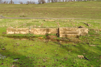
Above: the abandoned foundation of the historic Excelsior schoolhouse with its accompanying water well. A left side view of what would have been the front of the schoolhouse. Note the tree above. This picture was taken by Jeremy Tuggle on January 8, 2023.


Above: the concrete and stone water well of the historic Excelsior schoolhouse. This photograph was taken by Jeremy Tuggle on January 8, 2023.


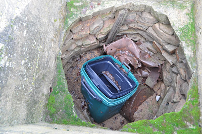
Above: a look inside the concrete and stone water well of the Excelsior schoolhouse which is plugged and filled with debris and oil drums. See the stonework inside it. This photograph was taken by Jeremy Tuggle on January 8, 2023.


Above: a look at the rear of the schoolhouse foundation with a staircase. Foster Road curves around the property of the schoolhouse. This photograph was taken by Jeremy Tuggle on January 8, 2023.


Above: a look at the front main entrance of the Excelsior schoolhouse. Note the tree in back of it. This photograph was taken by Jeremy Tuggle on January 8, 2023.


Above: this undated photograph of the Excelsior school shows exactly how the schoolhouse appeared. Note the tree in back of it, it's the same tree which is still standing in the above photographs. Courtesy of Shasta Historical Society.


RESOURCES:


School Districts of Shasta County 1853-1955 compiled by Veronica Satorius

Make School Census Returns - The Sacramento Daily Union newspaper of Sacramento, May 1, 1910

Teachers Chosen - The Searchlight newspaper of Redding, August 14, 1915

Family of Ten Aids School - The Healdsburg Tribune newspaper of Healdsburg, February 8, 1924

Metsker Maps, date surveyed: September 1959

Original School Location Map, of Shasta County, California, date surveyed: January 1992.

Today In History - The Redding Record Searchlight newspaper of Redding, May 3, 2014


Saturday, January 7, 2023

A Snapshot of Piety Hill


Above: the town of Piety Hill, date unknown. From the collection of Jeremy Tuggle.


Piety Hill is a fine example of a present-day ghost town, which was located in western Shasta County, California. This town was located about a quarter mile east of the present-day town of Igo, on what is now Cloverdale Road, and northward for 0.7 miles, however, the majority of these historic relics from this community is situated on private property which most of them are viewable by-passing motorists from the roadside. Piety Hill was established in 1849 as a gold mining camp and it eventually boasted of 1,500 residents including 600 Chinese settlers nearby due to the local mining claims in the area producing gold. The Chinese mined and worked their vegetable gardens here, there was no China town at Piety Hill.

In 1853, the lucrative Hardscrabble mine began its production of lucrative minerals by the Dry Creek Tunnel and Fluming Company, which began the construction of a water ditch by Chinese labor that is seen in this YouTube video here. It became a 22-mile-long water ditch which diverted water from the North Fork of Cottonwood Creek, Eagle Creek, Andrews Creek and the South Fork of Clear Creek. Then in 1857, gold pans yielded miners working their mining claims at Piety Hill from $60 to $190 per pan. At that time, the community was home to a few families in the area with children when they organized a school at that place and erected a schoolhouse. It was a booming up-and-coming place to live. In 1858, a man named Eugene Crowell kept a general merchandise store at Piety Hill which was a very successful business venture for him due to the production of gold from the local mining claims.

There are two stories of how Piety Hill received its name. Both are quite interesting and easy to believe. One account is that a family named McKinney moved into the area, having come from Piety Hill, Michigan, and the family members named their new home after their former hometown. Another explanation suggested by some historians is that this mining camp was occupied by religious groups which chose to name the community Piety Hill. Piety Hill does appear on the first official map of Shasta County which was surveyed by Colonel William Magee in February of 1862.

The present-day town of Igo began as the relocated community of Piety Hill. Residents moved in 1866, probably to segregate themselves from Chinese miners who were settling in Piety Hill, but also because people learned there was an ancient river channel under the community, making it reliable for well digging. George McPherson was the superintendent of the lucrative Hardscrabble mine as well. It was their hydraulic mining methods which also played a part in declining Piety Hill's growth while the nearby town of Igo burgeoned with success. 

In 1867, my paternal great-great-great grandfather the Reverend William Samuel Kidder, a pioneer Baptist minister, school teacher, farmer and miner, among other things, was recorded as living at Piety Hill, that year, after relocating his wife and children from French Gulch. His registration is found in the California, U.S., Voter Registers, 1866-1898. His occupation at that time was a post master but Piety Hill lacked a United States Post Office to send and receive mail which this notation meant that Kidder was employed as post master for the French Gulch United States Post Office. My ancestors eventually relocated from Piety Hill to Eagle Creek (now Ono) at a later date.

By 1868, it was generally thought that the local mines in the area of Piety Hill were worked-out but that wasn't the case. McPherson and his men at the Hardscrabble mine cleaned up from its tailings or dump pile several thousand dollars from gold which was the largest assessment of gold ever produced at that location. That year also witnessed the erection of a brand-new sawmill in the area by Petty & Company, yet this lumber mill was a short-lived business venture.

A year later, Shasta County resident Charles McDonald, a well-known stage proprietor operated an express called McDonald's Express which took passengers from Shasta amongst the following western Shasta County communities: Middletown, Centerville, Piety Hill, Horsetown, Janesville (now Gas Point), and Roaring River. Roaring River was the farthest southwest which this stage line traveled to at that time. Later on, in 1870, Alamarin W. Baker, a resident of Eagle Creek (now Ono) operated a stage line called Baker's Shasta & Red Bluff Express which took passengers from Shasta to Red Bluff (in Tehama County), while making stops in between at Piety Hill and Horsetown.

Even though Piety Hill appeared to be in a declining state the local schoolhouse in May of 1871, had forty-one students enrolled into their one-room schoolhouse. The teacher at that time was Joanna T. Casey. While locals were still prospecting the area for new prospects other mining claims were still being patented in the region into the 1880s and 1890s, and by the turn of the twentieth century, Piety Hill suffered quite a loss from local mines failing at their production of ore while very few residents remained at Piety Hill.

In 1915, the Hardscrabble mine at Piety Hill was worked by miners mining away in drifts and toiling away in shafts on the property while utilizing hydraulic mining methods as a source to extract the gold from this mine, which was located in Section 27, 34 and 35, Township 31 North, Range 6 West, 1/2 mile south of Igo, and consisting of 1,700-acres, of patented mineral land. The owners were the Happy Valley Land and Water Company of Olinda. A. E. Bowles was the president of this company. This company owned the old Dry Creek Tunnel and Fluming Company's water ditch, which was then known as the Happy Valley water ditch as seen in the above YouTube video.

Remaining points of interest from Piety Hill include a reservoir, the Dry Creek Tunnel and Fluming Company's water ditch, also known as the Happy Valley water ditch, pieces of structures and depressions in the ground which were from the cellars below the Chinese buildings. Look for these historical relics along Cloverdale Road the next time you drive by in your vehicle. You might be amazed at their existence. The death knell of this community which never established a United States Post Office to send and receive mail came in 1920 when the last two residents of Piety Hill died.


Resources:

Condition of Our Public Schools - The Shasta Courier newspaper of Shasta, January 30, 1858

To Miners - The Shasta Courier newspaper of Shasta, April 3, 1858

S. Of T. - The Shasta Courier newspaper of Shasta, October 23, 1858

Mining Improvement - The Sacramento Daily Union newspaper of Sacramento, May 21, 1861

California, U.S., Voter Registers, 1866-1898

Enterprising - The Shasta Courier newspaper of Shasta, January 25, 1868

Letter From Piety Hill - The Shasta Courier newspaper of Shasta, June 6, 1868

School Report - The Shasta Courier newspaper of Shasta, May 20, 1871

Notice of Application for Patent To Mining Claim - The Shasta Courier newspaper of Shasta, October 4, 1873

Big Interest in Shasta Are Sold - The Sacramento Daily Union newspaper of Sacramento, July 21, 1911

Happy Valley to Be Transferred - The Sacramento Daily Union newspaper of Sacramento, July 30, 1911

U.S., Appointments of U.S. Postmasters, 1832-1971

REPORT XIV OF THE STATE MINERALOGIST - MINES AND MINERAL RESOURCES OF CALIFORNIA - CHAPTERS OF STATE MINERALOGIST’S REPORT BIENNIAL PERIOD, 1913-1914. CALIFORNIA STATE MINING BUREAU, CALIFORNIA STATE PRINTING OFFICE, SACRAMENTO.

Mines and Mineral Resources of Shasta County, Siskiyou County, and Trinity County, by G. Chester Brown, ©1915 published by California State Printing Office.

My Playhouse Was a Concord Coach, an anthology of newspaper clippings and documents relating to those who made California history during the years 1822-1888, by Mae Hélène Bacon Boggs. Published by Howell-North Press ©1942

Shasta County, California A History by Rosena Giles, published by Biobooks, ©1949.

Way Back When - Myrtle McNamar, published by C.A.T. Publishing of Redding, California, 1952. 282 pages.

The Story of Western Shasta written by R.S. Ballou, The Covered Wagon, 1964, published annually by the Shasta Historical Society

Place Names of Shasta County by Gertrude A. Steger revision by Helen Hinckley Jones, ©1966 by La Siesta Press, Glendale, California

Mines and Mineral Resources of Shasta County, California – County Report 6 – by Philip A. Lydon and J.C. O’ Brien ©1974 by California Division of Mines and Geology

Monday, January 2, 2023

An 1850s Historic Water Ditch at Piety Hill


Video: ©2022.


Explore an 1850s historic water ditch in this video, which is located at Piety Hill, a former ghost town with a lucrative history in western Shasta County, California. This video was filmed in the summer of 2022.