

The Salt Creek Group of Mines was worked by E.P. Connor as early as 1897, and this lucrative mining property was abandoned in 1916. The largest producer of gold of this mining property is the Corrine mine. Filmed on location June 6, 2023. Find out more about the Salt Creek Group of Mines in this video from Exploring Shasta County History...
Subscribe To

 Posts
All Comments
Showing posts with label Salt Creek. Show all posts
Showing posts with label Salt Creek. Show all posts
Thursday, June 8, 2023

Sunday, November 13, 2022
Hand Carved Sandstone Blocks Along The Present-Day, Sacramento River Trail.
Before 1872, Redding was the end-of-the-line, for the Central Pacific Railroad which became very fortuitous in its role in the development of our county for ten years until the railroad resumed construction of its tracks and laid them north of Redding through the Sacramento River Canyon in 1883. During that year, these hand carved sandstone blocks were mounted and placed by Chinese laborers who were employed by the railroad company to lay tracks over various creek crossings in that region along the Sacramento River.
Now part of the scenic Sacramento River Trail, there function today serves as bridge foundations for a few pedestrian crossings from Salt Creek to Middle Creek. "Thousands of passengers and millions of tons of ore crossed over these foundations utilized by the railroad until 1939, when the railroad was rerouted over the high trestle east of the trail entrance as part of the construction of Shasta Dam."

Above: the remaining hand carved sandstone blocks are still intact on the Middle Creek crossing along the Sacramento River Trail. This photograph was taken by Jeremy Tuggle on October 27, 2022.

Above: a close-up of the remaining hand carved sandstone blocks at the Middle Creek crossing. This photograph was taken by Jeremy Tuggle on October 27, 2022.
Resources:
Trail plaque at Middle Creek on the Sacramento River Trail
Tuesday, November 1, 2022
THE SITE OF THE FORMER EUREKA SCHOOLHOUSE ON SALT CREEK (1875-1980)

Above: the Eureka Schoolhouse is pictured here with Olive (Meyer) Chatham (1881-1980) standing beside it. She was educated here as a child, and later in life, she was employed here as a teacher. She was a daughter of Shasta County pioneers Frederick Valentine Meyer Sr., and Caroline Louise (Notten) Meyer of Cow Creek. This photograph was taken in 1974. This building was demolished in 1980. Courtesy of Shasta Historical Society.
The Eureka School District, of Shasta County, held this school's grand opening on August 3, 1875, which pre-dated the establishment of the town of Bella Vista. The Eureka schoolhouse was a one-room clapboard style structure with a stove. The property included a well on the lot it stood on, and an outhouse. Today, nothing remains of these additions. This building was built primarily for education purposes and community meetings in the Cow Creek region. This area at that location was an agricultural area before it evolved into a busy lumber community known today as Bella Vista.
This building was located a few hundred feet north of Salt Creek and in between the Meyer and Lemm family ranches. It was the only school within the boundaries of the Eureka School District. By the 1970s, the building was left abandoned, and the structure was not brought up to county code and regulations for it to be salvaged. Then in 1980 this schoolhouse was demolished after it was in existence for 105 years. Today, the lot this schoolhouse formerly occupied remains vacant however the landscape hasn’t changed much over the years.
The following is a partial listing of known schoolteachers at the Eureka Schoolhouse:
1887 - Mary (Meyer) Love
1891 - Mary (Meyer) Love
1895 - Annie Durkee
1897 - Mary (Meyer) Love
1899 - Alma Sheppard
1906-1907 - Katherine (Smith) Lemm
1908 - Donna Dennis
1911-1912 - Olive (Meyer) Chatham
1912-1913 - Franklin R. Love
1915 - Ethel M. Williams

Above: formerly located on this flat surface of grassy land just off of Blue Sky Road (formerly Aloha Road) outside of Bella Vista, and a few hundred feet north of Salt Creek is the site belonging to former Eureka Schoolhouse. This land is located on private property. This photograph was taken by Jeremy Tuggle on September 27, 2022.
Resources:
Shasta County School Districts Plan Merger - The Chico Record newspaper of Chico, March 20, 1920
The Meyer Family Memories of Olive (Meyer) Chatham written by an unknown author, date unknown. Available at the Shasta Historical Society.
Shasta County’s Historical Rural School Eureka School by Ruth Martin and Jane Long PF 371.9 Martin (available at the Shasta Historical Society.)
Wednesday, October 13, 2021
POLLOCK; A FORMER TOWNSITE ON THE SACRAMENTO RIVER ARM OF SHASTA LAKE

The historic Pollock bridge above the Sacramento River in 1936 with the town of Pollock in the distance on the north-east side of the Pollock bridge. From the collection of Jeremy Tuggle.

Above: where Pollock should be at the mouth of Salt Creek on the Sacramento River arm at 115.20-feet below the crest of Shasta Dam. Time to compare the ridge line of the mountains in the background with the first picture. This photo was taken by Jeremy Tuggle on June 11, 2021.

Above: a 1915-1945 map which predates the establishment of the townsite of Pollock at the junction of Salt Creek and the Sacramento River. This map shows the former alignment of the Central Pacific Railroad which was later acquired by Southern Pacific Railroad. It shows what was known as the Shasta Route on this map at that location. Source: CalTopo.
Pollock was formerly located along U.S. Route Highway 99 at the junction of Salt Creek and the Sacramento River. Today, Pollock is located just opposite of Sugarloaf Resort and Antler’s Marina on the Sacramento River arm at the mouth of Salt Creek under Lake Shasta. Construction on U.S. Route Highway 99 (also known as the Pacific Highway) began in California in 1914 and it was finished in 1922. During the interim years, a man named George G. Pollock, a native of Indiana, and a general contractor owned and operated the Pollock Construction Company, of Sacramento, which was awarded a contract from the California State Highway Commission in 1916 to construct a bridge which would span the Sacramento River at this location. The bridge was open for auto travel in February of 1917.
Later, a fire broke out on August 11, 1921, at Pollock “...which destroyed seven outfit cars sidetracked there, found that it was due to hoboes entering one of the cars and building a fire for cooking or keeping warm, and failure to extinguish it entirely when leaving.” (SIC) As Pollock was emerging into becoming a permanent fixture along the new highway, north state locals Davis & Robinson obtained a permit from the local railroad commission to operate an automobile passenger stage line from Redding to Sisson (now Mount Shasta City) in Siskiyou County. Along the route this stage line conveyed passengers to Pollock, Delta, La Moine, Hazel Creek, Castella and Dunsmuir. It promised weary travelers fast traveling times at cheap rates.
It was Redding resident Chris Kutras who purchased eighty acres on the east side of the Sacramento River near the highway bridge from landowner Mrs. N.S. Stillson on February 17, 1922. Kutras promised that this transaction would include the erection of a general grocery store, combination post office and service station building to be leased to H.L. Scott. Scott was slated to be the first postmaster of this U.S. Post Office, but he was bypassed by the officials in Washington D.C., for unknown reasons.
Then, on January 5, 1924, John Steinaker became the first postmaster of the brand-new United States Post Office at Pollock. The Pollock United States Post Office was established by the United States Postal Service in Washington D.C., and they named the post office after George G. Pollock. It was a fourth-class post office which served about 30 families residing at Pollock. However, Steinaker had leased his store’s building from Kutras, and it was in operation before July of 1923 without the post office, which began serving the area on January 5, 1924.

Above: a 1939 mineral deposit map of Shasta County surveyed by Charles V. Averill showing Pollock and the railroad.

Above: the combined Pollock Grocery Store, Post Office & Service Station at Pollock owned by Chris Kutras and leased to John Steinaker on the Sacramento River at Salt Creek. Date unknown. Courtesy of Shasta Historical Society.

Above: originally labeled as the Pollack Auto Camp. This is the Pollock Auto Camp at Pollock on the Sacramento River at Salt Creek. Date unknown. Courtesy of Shasta Historical Society.
As early as April of 1925, talk of a dam being built in the Sacramento River Canyon was already mentioned in statewide media coverage, and the Healdsburg Tribune of Healdsburg, reported the following about submerging the town of Pollock within in the future reservoir of what would become Shasta Lake by the construction of this dam in the following article:
"Would Create Lake In Shasta County
SACRAMENTO, April 10.- A dam in the Sacramento River canyon at the proposed Kennett site would submerge the towns of Kennett, Antler, Copper City and Pollock, twenty miles of the main line of the Southern Pacific, nine miles of the stale highway, two smelters, one mine and the state fish hatchery on the McCloud River. These consequences of the backing up of water in the Sacramento and Pit Rivers for thirty-two miles with a 400-foot dam are discussed by Paul Bailey, engineer who is making the survey of the state’s water resources begun in 1921, in his supplemental report on the work to date made to the present legislature."
Six years later, a brush fire erupted into flames two miles south of the town of Pollock in April of 1932 on the Kobe farm which resulted in the death of resident Mathew Kobe, age seventy-two, a native of Austria, and a local farmer. He had been fighting the fire when his trousers got caught in the flames and he jumped into Salt Creek to extinguish them. The flames caused serious burns upon his body, and in time, those burns were fatal to him. Kobe died on April 18, 1932, the decedent was survived by his wife, four sons and one daughter. The fire grew to two acres with no structure damage.
Beginning May 1st, of each year swimming at Salt Creek kicked off and even during the summer months Pollock residents were able to cool off in the creek which flowed year round. It would rise during rain storms. Much like today, even the local wildlife shared the running water of Salt Creek with their human neighbors.

Above: an article about Pollock happenings from the Courier-Free Press newspaper of Redding, dated: May 1, 1935, Pollock was a lively place along the Pacific Highway during the decade of the 1930s.
The town of Pollock was flooded during the historic Sacramento River flood of February 28, 1940, with winter storms flooding the river at that location, as Pollock got its first taste of being submerged in water. The flooding caused the Pollock bridge to be under six feet of water and at Woolman's store. The City of Redding was isolated in all directions which saw the traffic and the railroad trains stopped in all directions until the routes were passable a week later when the flood water lowered.
Four years later, on June 1, 1944, the Pollock United States post office was discontinued with Sarah Ann Moody being the last postmistress. Then it’s post office was relocated. The name of this United States post office was changed to Loftus in honor of Charles Loftus, a grandson of Mrs. Stella Woolman. The reason the Pollock United States post off was discontinued was due to the construction of Shasta Dam which threatened with submerging the town site into the reservoir of Shasta Lake (or Lake Shasta). Pollock would eventually become under the main water mark of the reservoir at full pool 1,067-feet elevation or distance from crest of Shasta Dam at 0-feet, with its 365 miles of shoreline. Lake Shasta began flooding its reservoir in 1942. Shasta Dam was engineered by Frank T. Crowe the owner of Pacific Constructors Incorporated, and construction began in 1938 and its construction was completed in 1945.
The Pollock townsite has surfaced during the drought years of 1976, 1977, 1991, 2008 and 2021 with portions of historic U.S. Route Highway 99 surfacing and the railroad of the Central Pacific built in 1884 and later acquired by the Southern Pacific Railroad this railroad was also known as the Shasta Route and traversed on the westside of the Sacramento River at Pollock. During these years, local Pollock relics included a 1916 cut and grade and a highway masonry wall with minimal foundations. The Pollock bridge is fully out of the water at 166.87-feet below the crest of Shasta Dam; and in the 1990's the resort that owned the bridge cut the bridge in half and repositioned it at an angle so they could start launching boats off of it during drought years, so not all of the bridge is intact. The Sacramento River arm at this location has changed drastically over the years. On July 11, 2021, the historic Pollock bridge began emerging out of the water at Lake Shasta for the first time in seven years at 131.15-feet below the crest of Shasta Dam.
POLLOCK POSTMASTERS:
John Steinaker - January 5, 1924
Mrs. Stella Klineschmidt - acting P.M. June 7, 1926, appointed June 10, 1926
Mrs. Stella Woolman (formerly Klineschmidt) - July 23, 1930
Mrs. Florence Mason - November 16, 1940
Mrs. Hazel N. Collins - April 23, 1942
Mrs. Sarah Ann Moody - December 1, 1942
Mrs. Sarah Ann Moody - June 1, 1943 - June 1, 1944.
Above: on top of the 1916 cut and grade (which is used for vehicle parking) on the north side of the Pollock bridge at Antler's Marina with historic U.S. Highway Route 99 below me. The Lake Shasta water level was 135.00-feet below the crest of Shasta Dam. This video was filmed on location July 16, 2021.
Above: Portions of the historic railroad at Pollock surfacing out of the water at Shasta Lake. This is the railroad just north of the historic Pollock bridge. This video was filmed on location, September 4, 2021.

Above: the end of the Pollock bridge. The Pollock bridge is now full out of the water on 9-10-2021 at 900.13-feet elevation wise or 166.87-feet below the crest of Shasta Dam. This photograph was taken by Jeremy Tuggle.
Above: Jeremy Tuggle discovers a foundation of a building possibly connected to the Shasta Route Railroad at Pollock, just north of the historic Pollock bridge, at 891.58-feet elevation wise below full pool or 175.42-feet below the crest of Shasta Dam. Filmed on location on October 2, 2021 in Lakehead, California.
(Note: this article was featured in the October 2021, Shasta Historical Society Stagecoach newsletter, page 9, written by Jeremy Tuggle for the Shasta Historical Society.)
RESOURCES:
Canyon Roads Open For Automobiles - The Searchlight newspaper of Redding, February 16, 1917
Sacramento Canyon Open To Auto Travel - The Sacramento Daily Union newspaper of Sacramento, February 16, 1917
Road From Redding To Dunsmuir Finished - The Sacramento Daily Union newspaper of Sacramento, February 18, 1917
Marin Journal newspaper of San Rafael, April 12, 1917
1920 U.S. Census
The Searchlight newspaper of Redding, February 4, 1921
The Searchlight newspaper of Redding, August 21, 1921
The Searchlight newspaper of Redding, September 27, 1921
Stage Permit Granted - The Sacramento Daily Union newspaper of Sacramento, September 28, 1921
Pollock Will Have Post Office Store - The Courier-Free Press newspaper of Redding, February 17, 1922
Chris Kutras Buys 80 At Pollock - The Searchlight newspaper of Redding, February 17, 1922
The Searchlight newspaper of Redding, July 19, 1922
The Searchlight newspaper of Redding, April 7, 1923
Automobile Truck Had Five Million In Gold As Cargo - The Searchlight newspaper of Redding, May 29, 1923
Pollock Wants To Have A Post Office - The Searchlight newspaper of Redding, June 23, 1923
For Pollock - The Searchlight newspaper of Redding, July 10, 1923
Kennett-Pollock Road May Get State Money To Be Used As Detour - The Courier-Free Press newspaper of Redding, March 22, 1924
Would Create Lake In Shasta County - The Healdsburg Tribune of Healdsburg, April 10, 1925
Former Pollock Merchant Asks Divorce - The Searchlight newspaper of Redding, June 10, 1925
The Courier-Free Press newspaper of Redding, August 20, 1925
Folks You Know - The Courier-Free Press newspaper of Redding, January 23, 1932
Personal - The Courier-Free Press newspaper of Redding, February 9, 1932
Pollock Man's Death Blamed On Trousers - The Courier-Free Press newspaper of Redding, April 18, 1932
The Courier-Free Press newspaper of Redding, January 9, 1935
The Courier-Free Press newspaper of Redding, January 12, 1935
Pollock Woman Struck By Small Boy In Snowball - The Courier-Free Press newspaper of Redding, January 31, 1935
Camp Salt Creek Quarantine Lifted - The Courier-Free Press newspaper of Redding, February 7, 1935
Local Brevities - The Courier-Free Press newspaper of Redding, February 22, 1935
The Courier-Free Press newspaper of Redding, March 9, 1935
Highway Rerouting Is Studied - The Courier-Free Press newspaper of Redding, March 16, 1935
The Courier-Free Press newspaper of Redding, April 2, 1935
Pollock - The Courier-Free Press newspaper of Redding, April 8, 1935
Pollock - The Courier-Free Press newspaper of Redding, April 18, 1935
Pollock - The Courier-Free Press newspaper of Redding, April 20, 1935
Pollock - The Courier-Free Press newspaper of Redding, April 23, 1935
Pollock - The Courier-Free Press newspaper of Redding, April 27, 1935
Pollock - The Courier-Free Press newspaper of Redding, May 1, 1935
Pollock - The Courier-Free Press newspaper of Redding, May 8, 1935
Pollock Items - The Courier-Free Press newspaper of Redding, May 17, 1935
Pollock - The Courier-Free Press newspaper of Redding, May 18, 1935
Pollock - The Courier-Free Press newspaper of Redding, June 4, 1935
Pollock - The Courier-Free Press newspaper of Redding, June 11, 1935
Pollock - The Courier-Free Press newspaper of Redding, June 18, 1935
Pollock - The Courier-Free Press newspaper of Redding, July 9, 1935
The Courier-Free Press newspaper of Redding, August 12, 1935
Pollock Items - The Courier-Free Press newspaper of Redding, August 17, 1935
Pollock Items - The Courier-Free Press newspaper of Redding, August 22, 1935
Pollock Items - The Courier-Free Press newspaper of Redding, September 4, 1935
U.S., Appointments of U. S. Postmasters, 1832-1971
Redding Isolated - The Courier-Free Press newspaper of Redding, February 28, 1940
That Ribbon Of Highway I: Highway 99 from the Oregon Border to the State Capital by Jill Livinston 1996 0-9651277-3-2 Second edition. Published by Living Gold Press. 212 Pages.
Friday, July 19, 2019
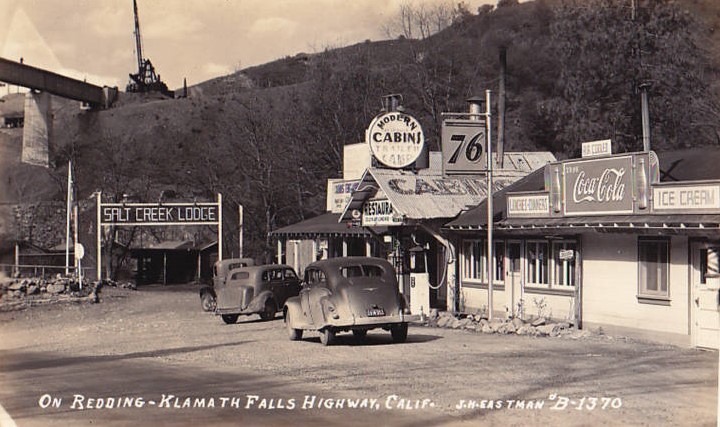
ON REDDING-KLAMMATH FALLS HIGHWAY, CALIFORNIA
Courtesy of David Stuart.
A friend of mine sent me this wonderful image which is titled, “On Redding-Klamath Falls Highway, Calif.”. It’s a photograph captured in the late 1930s by J.H. Eastman, a local photographer when he was at Salt Creek, now part of present day Lake Shasta or Shasta Lake. The highway route is actually historic U.S. Route Highway 99. It’s still there today on Lower Salt Creek Road in the Sacramento River Canyon. Thank you, David for the intriguing postcard!
Wednesday, December 26, 2018
LOWER SPRINGS

Above: a cabin at Lower Springs. This photograph was taken in 1900. Courtesy of Shasta Historical Society.
After the first two gold discoveries in California were confirmed to be true, scores of people descended into California from around the world, and onto the Rancho Buena Ventura in 1849. As Gold Rush pandemonium struck this region and populated places near it, the forty-niners began pitching up their tents at a rapid pace. These people made their camp sites about two miles southeast of Reading Springs. After that, they began to prospect the nearby creek channels to stake out their placer mining claims. Not everyone was successful at mining.
At this location, a tent community called Lower Springs was established by these forty-niners, that year. Lower Springs became one of the original gold rush communities of Shasta County. This new tent community was named Lower Springs because its name derived from the nearby community of Reading Springs. Later on, the name of Reading Springs was changed to Shasta on June 8, 1850, and the community of Lower Springs kept its name.
A man by the name of Benjamin Swasey was among the first settlers of this flourishing mining community. He was a native of New Hampshire and he arrived in Shasta County in 1849. After his arrival, the Lower Springs mining district formed its boundaries in the area. Some people made their fortune while others weren't as lucky, yet these miners kept locating new placer mines in this mining district. During the summer months, the Lower Springs mining district became dry diggings with the lack of rain, and water resources were unavailable for miners to use in their placer mines at that time.
Eventually, the rain fell and restored the water in the creek channels every year, as early as fall or as late as winter, however; summer rain storms were known to happen. It was Swasey who purportedly owned some land near Lower Springs at Gold Gulch. Gold Gulch was a tributary of Salt Creek which reportedly yielded him, $1,500 to the cubic yard in gold. Salt Creek was another stream which channeled near Lower Springs.
In 1850, the first wooden home structure was erected at Lower Springs, and soon after, other homes were completed with additional bungalows and cabins. Lower Springs had a thriving population during its hey-day, the exact number of settlers weren't recorded. However, Lower Springs' population fueled this flourishing community to be a contender for the county seat of Shasta County, along with Horsetown and Shasta, in the running on the ballot at the local primary election in 1851. This is when the county seat was removed from the Reading Adobe at Cottonwood to Shasta.
Then on, March 6, 1851 the town of Shasta became the second county seat of Shasta County. The original location of Lower Springs was on the stage road which routed rigs from Canon House (Canyon House) to Shasta. The current site is located a quarter-mile west of the junction of Highway 299 and Ridge Drive.
The burgeoning community of Lower Springs was prone to Indian attack's, and the Indians raided many cabins in the area at that time, taking with them all of the supplies and provisions the early settlers owned. Then on, April 17, 1851, a man by the name of Merady Swan, a native of Missouri, was murdered by Indians in this community. The following article is from the Sacramento Transcript newspaper of Sacramento:
"Killed By Indians - A man named Merady Swan formerly of Missouri, was shot in his cabin at Lower Springs, two miles this side of Shasta City, one night last week. The Indians slipped up to his cabin at night and shot him through a crack in the door, while he was sitting at the table. Several other persons were in the house, which prevented them from robbing it." (SIC)
In May of 1852, the miners of this mining district were averaging five dollars to the pan per day on Salt Creek. A new settler to the area by the name of Jonathon F. Gage, a native of New Hampshire, erected a log style house there. Gage was married to Alice Jane Swasey a sister of Benjamin Swasey. Jonathon’s profession was farming but he also tried his hand at mining. Together they raised a large family, and then in 1866 they relocated from Lower Springs to Middletown, this is where Gage registered to vote that year.
In 1853, Benjamin Swasey filed a land claim at Shasta, for one hundred and sixty acres of land at Lower Springs, and then he erected a house on this property for him to live in. He also erected two additional buildings at Lower Springs for his businesses. Swasey became the proprietor of the Swasey hotel and the Swasey mercantile store. The hotel included a large barn and a corral with a natural spring of water. Hay and barley were also stocked in the hotel's barn. His business prospered as Swasey advertised in the Shasta Courier newspaper from Shasta.

Above: an advertisement for Swasey's hotel at Lower Springs, the ad above is from the Saturday, January 21, 1854 edition of the Shasta Courier newspaper.

Above: this is an upper torso photograph of an elderly, Benjamin Swasey. Benjamin was born on January 31, 1822 in New Hampshire and he died in Oakland, Alameda County, California on September 19, 1912, at the age of ninety. He is buried at Redding in the Redding Memorial Park. He was married twice, first to Nellie Dalton, and second to, Emily Marshall. Then in 1861, Swasey became a photographer and relocated to San Francisco. This image was taken circa 1880s at Vance's Gallery in San Francisco. Courtesy of Shasta Historical Society.
Aside from the businesses owned by Benjamin Swasey, this community also included a boarding house called the Virginia House and a blacksmith shop which was owned and operated by Henry Jones. Jones was a native of Ohio, and he was married to his wife, Emily. There was at least one son produced during this union which they named James Jones. At a later date, Henry Jones changed his profession to become a gunsmith.
Then on, Saturday, April 2, 1853, the Shasta Courier newspaper reported the following information in the forthcoming article:
"DIGGINGS ABOUT LOWER SPRINGS - We have heard of remarkably good wages being made within the past few days in these diggings, and what is more, we know it to be true. Dr. Dunlap, in digging a cellar under his house, took the trouble to prospect the dirt, and found it paid upwards of two cents to the pan from the surface to the bed rock. This ground of course would pay fine wages for sluicing, if water was to be had." (SIC)
Later that month, additional excitement occurred at the placer mines on the hillside above the Virginia House, which yielded lucrative results to local miners. Miners also crossed the main stage road to the land opposite of the boarding house and they made the most gratifying success there. There were many delightful parties were held at the Swasey house where people danced the night away and during each ball a supper was prepared by Swasey’s wife, Nellie, to serve the guests. Anyone was welcome to join them and it was a great way for the lonely miners of the area to interact with the beautiful and single ladies.
The following year, the miners of the area were extremely harsh on the Chinese immigrants in the Lower Springs mining district, and at that time, they voted to ban all Chinese immigrants, and then, they forced them to turnover their mining properties to the miners of the area which were not of that race, and the "white miner" weren't the only race to enforce this policy. Hong Kong, near Shasta was closest Chinatown to Lower Springs, which was located two miles away. There were quite a number of anti-Chinese mining districts in Shasta County. Lower Springs wasn't the only mining district to evict the Chinese.
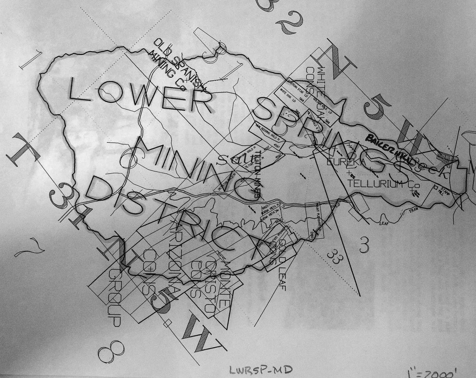
Above: This undated surveyed map shows the boundaries of the Lower Springs mining district and some of the mines included. Please note the name: the Old Spanish Mining Co., of course other mines and companies are noted on it as well.
In the fall of 1854, a brand new trading post was established at Lower Springs by J.D. Dunlap & Company, and they began advertising their general merchandise store in the local media. Two months later, in December of that year, the first rain eventually fell, and miners had an abundance of water to use. The miners started washing their placer mines and they were making one hundred dollars per day by rocker at that time.

Above: an advertisement for J.D. Dunlap & Company at Lower Springs. This ad is from the Saturday, October 21, 1854 edition of the Shasta Courier newspaper.
The construction of the Clear Creek Ditch, sometimes referred to as the Clear Creek Canal, began in December of 1853. Local miners raised the money to back this large project to convey the water of Clear Creek into the nearby dry diggings of Briggsville, Horsetown, Lower Springs, Muletown, Shasta and Whiskeytown. The ditch connected with a large reservoir which was built as a major part of this project.
Local miners celebrated the ditches completion on November 24, 1855. The length of this ditch measured at sixty miles. The reservoir at Middletown covered fifteen acres to a depth of eight feet. Immediately, the water from this ditch began conveying water into the Lower Springs mining district at Salt Creek. The miners at Lower Springs now had an abundance of water to use in their mining claims.
There wasn't much of a ruckus at Lower Springs between the years 1856 and 1857; however, this community managed to stay relevant. The miners in the area focused on their placer mines, and local businesses advertised their companies in the local media. However, in July of 1857, Swasey’s hotel was still owned by Benjamin Swasey, but it was now under new management. A man by the name of Willam H. Bond was hired by Swasey to manage the hotel for him. Swasey still ran his mercantile store but his extra time was focused on being the public administrator of Shasta County, which is part of the reason he couldn’t manage both the mercantile store and the hotel by himself.

Above: an advertisement for the Administrator's Sale of Real Estate for the estate of T.B. Pritchett, deceased. This estate sale was held on Main Street at Texas Springs, in Shasta County, by Benjamin Swasey, Public Administrator on August 22, 1857. The above ad is from the Saturday, August 8, 1857 edition of the Shasta Courier newspaper.
Two years later, on February 19, 1859, the Shasta Courier newspaper heralded the following article:
“Pottery - The manufacture of pottery has been fairly commenced by Messrs., Bly & Co., at Lower Springs. It is the first manufactory of the kind that we have heard of being established in the Northern part of the State. The first kiln was burned a few days ago. It was entirely successful and the ware is of excellent quality. We have been presented with a large pitcher from this first kiln and we value it highly. It argued well for California to witness the commencement of manufacturing establishments throughout the State - however, humble they may be in their inception. We wish Messrs., Bly and Co., an abundant reward in the pursuit of their laudible enterprise.” (SIC)
Apparently, the above article by the Shasta Courier newspaper conflicts with previous statements by local historians who claimed that, a man by the surname of Tozure, had owned and operated the first pottery shop at Lower Springs. There's no information to suggest that Tozure was employed by Bly and Company, or that Tozure had become Bly and Company’s successor at Lower Springs. There might have been two different pottery shops at different era's in this community, in operation, because the above article suggest otherwise.
This quiet burg was interrupted one day, in January of 1863, by an affray started by Lawrence O' Connell who assaulted William Thompson over a bottle of strychnine whiskey. This is one incident that the local media frenzied over. It was Thompson who was severely beaten by O’ Connell that day, and after the violent dispute, O'Connell immediately departed Lower Springs for Latona. Thompson traveled to Shasta where he pressed charges of assault against his assailant at the Sheriff’s office. O’Connell was later arrested at Latona by Sheriff John S. Follansbee, and then, Follansbee escorted him to Shasta where he was jailed.
In June of 1863, Jones & Company struck a fine ledge of gold particles on their mining property at Lower Springs. They believed that this ore would carry a high value at the assayers office and it won them quite a bit of praise in the local media. The ledge was measured at twenty-two feet wide, immediately, Henry Jones and his crew sunk a shaft down twenty feet below the surface of the earth.
As they continued to lower the shaft, the ore they sought after revealed better quality. This discovery brought a boom to the community of Lower Springs, and it became one of the first quartz mines in the Lower Springs mining district. Everything until then had been placer mining, in that area, Jones & Company would soon develop the property further with tunnels, drifts and upraises. Its believed that this former placer mine became the quartz mine known as the Old Spanish Mine.
After this quartz mine was dug out, a number of placer mining properties in the Lower Springs mining district were transformed by miners into quartz mines. In November of 1864, Henry Jones who was one of Lower Springs leading citizens was elected as Supervisor of District 1 of Shasta County, the local media referred to Jones as being “eminently qualified for the position”. That month, a number of large quantity of rocks from the Old Spanish Mine at Lower Springs was hauled to the Spring Creek stamp mill on Spring Creek to be crushed so they can obtain the gold from the quartz rocks.
Then on, Saturday, March 4, 1865, the Shasta Courier heralded the following account of a recent discovery made by Henry Jones:
“A SWEET DISCOVERY - Last week Mr. Jones, of Lower Springs observes s large number of honey bees working upon the willows in that vicinity, and being quite an expert apiarist, he noticed that in leaving the willows they generally flew in the same direction, and by taking observations from some willows in the vicinity of Mr. Wiser’s garden he saw that the course taken by the bees from the two points converged upon a hill about a half mile from Lower Springs, and upon going to the place, he found the bees occupying a log upon the hill. The log was opened and forty pounds of excellent honey taken therefrom and sufficient left for the bees, which Mr. Jones has taken to his house.” (SIC)
A man named Bert Wiser partnered with a another man by the surname of Terry and together they established an excellent vineyard at Lower Springs. Wiser & Terry were well-known purveyors of wine which became a locally renown favorite of the era. Their wine was bottled at their Lower Springs vineyard and then transported to Wiser’s home at Buckeye, in Shasta County. He lived on the Buckeye Ranch where Wiser & Terry kept a rather large cellar that they stored their wine in. Their wine was labeled as Wiser & Terry, Lower Springs, California.
Another serious affray occurred in this community on March 15, 1865, when a shooting of a Chinaman transpired over an apparent purchase of a mining claim and water ditch. The German settler who apparently sold the property to the Chinaman denied the fact that he had sold him the land. Then the German claimed that he didn't realize the area was an anti-Chinese district. After they quarreled- the German shot the Chinaman in the arm and the feud was settled according to reports, but both parties lived, and no one was arrested.
On September 9, 1865, the local media reported the following;
"We are advised that there are fair prospects for the erection of a small mill at Lower Springs, this fall. - The good work goes on, and if the people will but prospect, the future of Shasta is assured." (SIC)
The above quote by the Shasta Courier newspaper is referring to a brand new stamp mill to help crush the rock to obtain the ore from the samples they retrieved. The mining company to establish this new stamp mill at Lower Springs was the Union Company who hired a man by the name of L.A. Kelly to be their superintendent at the stamp mill and supervise their daily operations here. The Union Company's stamp mill wasn't in operation until mid-December. It's not known how many stamps this crusher had.
Between the years 1866 and 1870, there were newer quartz mines which were located in the Lower Springs mining district. The quartz rock from these mines were hauled to the Union Company's stamp mill or the Spring Creek stamp mill. The ore from these mines were assayed at high value, and due to this mining boom these lucrative quartz mines brought new settlers to the area. The Union Company actually began to dig and blast through surface rock to make their own quartz mine at their stamp mill property to prospect.
While the decade of the 1870s and 1880s evolved around the mining district at Lower Springs, the (old) gold mining burg flourished once again as work continued in number of mines in the area. One quartz mine in particular is the Old Spanish Mine, which is located in the Lower Springs mining district. Throughout history, this mining burg never established a post office, and it continued to be prominent into the 1890s, and past the turn of the 20th century. Today, Lower Springs Road retains the name of this once thriving gold rush community and present day Swasey Drive was named after forty-niner, Benjamin Swasey.

Above: In January of 1905, this plat map of the Telluride Consolidated Mine was surveyed by Alfred Baltzell, an U.S. Deputy Mineral Surveyor, for its owners Charles Piftschek, and Anton Herzlieb, of Redding. The Telluride Consolidated Mine embraced the Tellurium Quartz Mine, Diagonal Quartz Mining Claim, and the Hill Gravel and Quartz Mining Claim. All of these were located on the property of Piftschek and Herzlieb.

Legend has it that these iconic palm tree's were planted by pioneer, Benjamin Swasey at Lower Springs, and they grew in front of his Swasey hotel. The palm tree's lasted until the decade of the 1970s when the area was developed and they were uprooted. This photograph was taken in 1972. Courtesy of Shasta Historical Society.
RESOURCES:
1850 U.S. Census
Killed By Indians - The Sacramento Transcript newspaper of Sacramento, April 17, 1851
From The Interior - The Sacramento Daily Union newspaper of Sacramento, May 31, 1852
Lower Springs - The Shasta Courier newspaper of Shasta, March 12, 1853
Diggings About Lower Springs - The Shasta Courier newspaper of Shasta, April 2, 1853
The Lower Springs Road - The Shasta Courier newspaper of Shasta, May 7, 1853
The Ball At Lower Springs- The Shasta Courier newspaper of Shasta, January 21, 1854
J.D. Dunlap & Co. - The Shasta Courier newspaper of Shasta, October 21, 1854
Lower Springs - The Shasta Courier newspaper of Shasta, December 23, 1854
A Serious Difficulty - The Shasta Courier newspaper of Shasta, January 13, 1855
Convention of Shasta County Miners Relative to the Chinese Question - The Shasta Courier newspaper of Shasta, January 20, 1855
Clear Creek Ditch - The Sacramento Daily Union newspaper of Sacramento, October 29, 1855
Clear Creek Ditch Finished! - The Shasta Courier newspaper of Shasta, November 24, 1855
Swasey’s Hotel advertisement - The Shasta Courier newspaper of Shasta, July 11, 1857
Slanderous - The Shasta Courier newspaper of Shasta, February 19, 1859
1860 U.S. Census
Supervisor - The Shasta Courier newspaper of Shasta, November 19, 1864
Quartz - The Shasta Courier newspaper of Shasta, November 26, 1864
A Sweet Discovery - The Shasta Courier newspaper of Shasta, March 4, 1865
Shot - The Shasta Courier newspaper of Shasta, March 18, 1865
Still Another Mill - The Shasta Courier newspaper of Shasta, September 9, 1865
Lower Springs - Union Co. - The Shasta Courier newspaper of Shasta, December 9, 1865
New Discovery - The Shasta Courier newspaper of Shasta, January 6, 1866
New Discovery - The Shasta Courier newspaper of Shasta, January 6, 1866
Struck It - The Shasta Courier newspaper of Shasta, February 10, 1866
Prospecting Mill - The Shasta Courier newspaper of Shasta, March 10, 1866
Buckeye Ranch - The Shasta Courier newspaper of Shasta, April 1, 1865
1866 California Voters Registration
1870 U.S. Census
1880 U.S. Census
California Journal of Mines and Geology, Volume 10 1890, page 632.
1866 California Voters Registration
1870 U.S. Census
1880 U.S. Census
California Journal of Mines and Geology, Volume 10 1890, page 632.
Mining District Near Redding’s Limits - Mineral Wealth Magazine, March 15, 1905
Benjamin Swasey Dies At Home In Oakland - The San Francisco Call newspaper of San Francisco, September 20, 1912
My Playhouse Was A Concord Coach, an anthology of newspaper clippings and documents relating to those who made California history during the years 1822-1888, by Mae Hélène Bacon Boggs. Published by Howell-North Press ©1942
Shasta County, California A History by Rosena Giles, published by Biobooks, ©1949.
Lower Springs by Mabel Frisbie - The Covered Wagon, 1957, published by Shasta Historical Society.
In the Shadow of the Mountain A Short History of Shasta County, California, by Edward Petersen ©1965
Gage-Carter Family Stories, Compiled for Lloyd D. Carter, edited by M. Walsh © October 1990 929.2 Gage/Carter in Shasta Historical Society library
Middle Creek & Lower Springs Mining District 622 Mining, available at the Shasta Historical Society
Tuesday, September 18, 2018
The Corrine: A Lucrative Mining Property

Adit one of the Corrine mine. This photograph was taken by Jeremy Tuggle on August 1, 2016
The Corrine mine was part of the Salt Creek Group of Mines which included the Bonanza, Gold Coin, Jumbo and Phoenix claims. The Corrine was the largest lucrative producer of gold amongst them. It is located one mile west of Redding on Salt Creek, and was originally in the Lower Springs mining district. The mine is on the opposite side of the Salt Creek Trail along Highway 299 West. A miner and prospector by the name of E.P. Connor owned the mine in 1897. That year, Connor had an arrastra erected on his Salt Creek mining property.
The arrastra measured at 10 inches in diameter and it was used to help crush the ore. A ditch was dug by his miners from Salt Creek to the mining claims on the property. When water was available it assisted the miners in the extraction of the ore they sought after. In later years, the arrastra was torn down and it was replaced by a stamp mill. The stamp mill crushed the rock in a vertical position rather than a circular position like an arrastra did.
In 1901, C. Watson & W.D. Watson acquired a lease from Connor to work the mining property. The Watson brothers were exploring in a crosscut tunnel of 100 feet on the property and they cut out new drifts which were 3 ft., on the ledge of the tunnel. Drifts were a slightly horizontal passage ways which followed a vein of ore. They were also working on a series of upraises.

Above: a portion of the Corrine mining property, along Salt Creek. This photograph was taken by Jeremy Tuggle on August 1, 2016.
In 1915, the Corrine mining property included 160 acres of land and it was owned by E.P. Connor and J.C. Connor of Redding. They hired two miners to operate their mine that year. The property contained four tunnels ranging between 60 to 430 feet long, and a 110 foot shaft, in which their miners toiled away in as they extracted the ore. The gold is mixed in with sulphides. It also contained a 200 foot pay shoot which was 15 inches wide.

Above: adit two with its iron gate intact. This photograph was taken by Jeremy Tuggle on August 1, 2016.
The Connor siblings placed a five stamp mill on the property which weighed 750 pounds in stamps. It crushed the rock for them that they obtained on the property. They also placed one Wilfrey table on the property. Wilfrey table’s were concentrating tables used by miners for preliminary scaling. A year later, the production of the Corrine mine stopped and the mine laid idled and abandoned. The production notes for this mine were not kept.
On July 23, 2018, the Carr Fire which began near the junction of Carr Power House Road and Highway 299 West at Whiskeytown district ravaged places in its course of destruction from there to this historic mining site. The fire burnt through Salt Creek’s channel and burned through the abandoned mine. Today, its part of the Kett mining district due to the boundaries of the Lower Springs mining district changing. The adits on the property survived the disastrous flames but the adit of number two had its iron gate blown out.

Above: the destruction from the Carr Fire. A burnt out Salt Creek channel at the Corrine mine. This photograph was taken by Jeremy Tuggle on August 12, 2018.

Above: the destruction from the Carr Fire, a portion of the Corrine mine tailing's. This photograph was taken by Jeremy Tuggle on August 12, 2018.

Above the destruction from the Carr Fire at adit one. This photograph was taken by Jeremy Tuggle on August 12, 2018.

Above: a close-up of adit one at the Corrine mine. This photograph was taken by Jeremy Tuggle on August 12, 2018.

Above: looking in between the iron gate at the entrance of the tunnel of adit one. This photograph was taken by Jeremy Tuggle on August 12, 2018.

Above: destruction from the Carr Fire, note the burnt ground. A portion of the Corrine mining property, along Salt Creek. Above: a portion of the Corrine mining property, along Salt Creek. This photograph was taken by Jeremy Tuggle on August 12, 2018.

Above: destruction from the Carr Fire, note the burnt ground. A portion of the Corrine mining property, along Salt Creek. Above: a portion of the Corrine mining property, along Salt Creek. This photograph was taken by Jeremy Tuggle on August 12, 2018.

Above: adit two with its iron gate blown out. Note: the burnt rock walls. Destruction from the Carr Fire, the fire went inside this portion of the tunnel. This photograph was taken by Jeremy Tuggle on August 12, 2018.
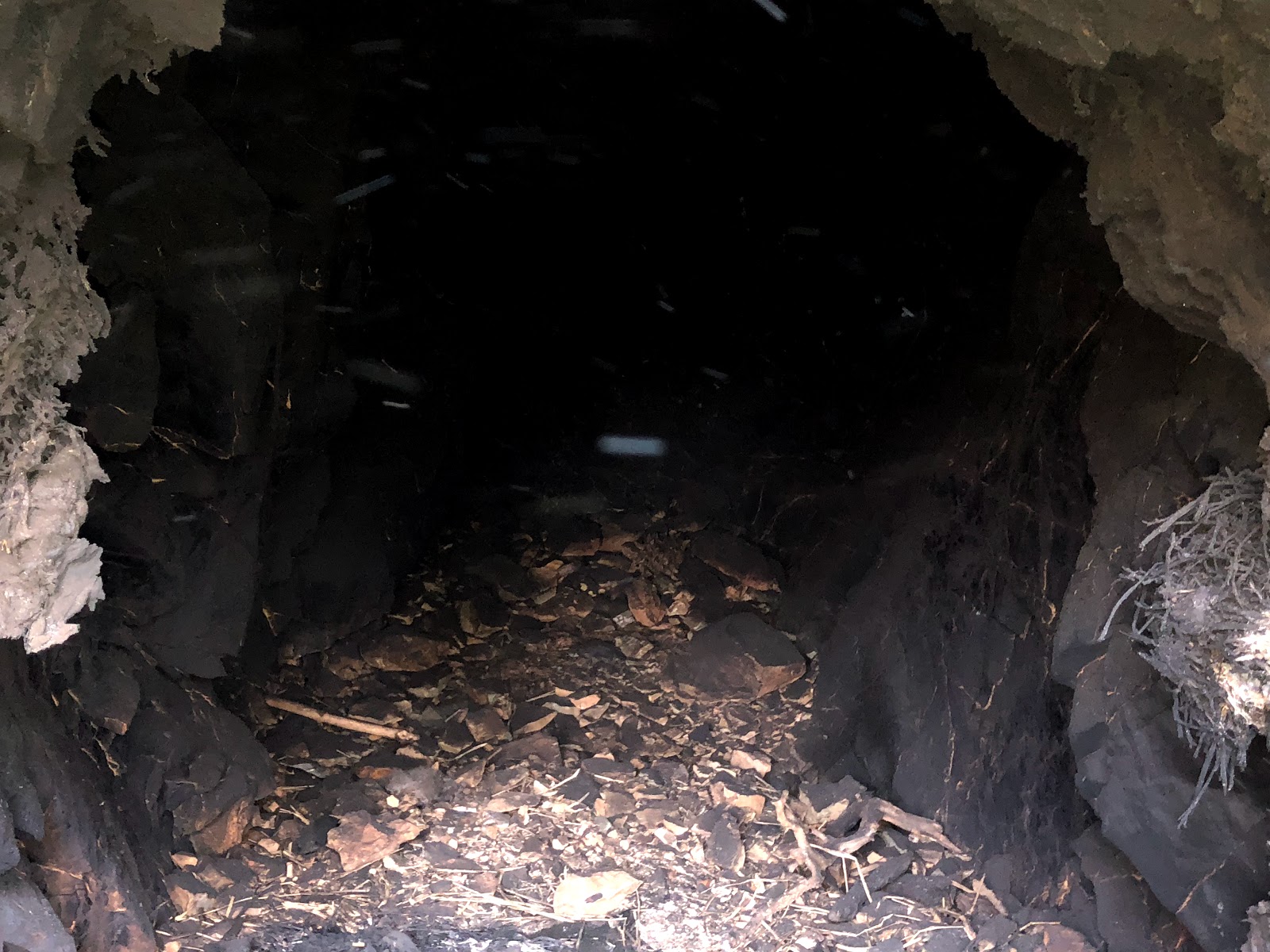
Above: the view inside adit two. Note: the burnt rock walls. Destruction from the Carr Fire, the fire went inside this portion of the tunnel. This photograph was taken by Jeremy Tuggle on August 12, 2018.

Above: a slightly different view of adit two. Note: the burnt rock walls. Destruction from the Carr Fire, the fire went inside this portion of the tunnel. This photograph was taken by Jeremy Tuggle on August 12, 2018.
RESOURCES:
Appendix to the Journals of the Senate and Assembly of the Thirty-Second Session, of the Legislature of the State of California, Volume V. Report of State Mineralogist ©1897 Sacramento, California, by A.J. Johnston, page 364.
Mining Notes - The Shasta Courier newspaper, February 25, 1899
The Engineering And Mining Journal Volume LXXII ©1901, Page 146.
Mines and Mineral Resources of Shasta County, Siskiyou County, and Trinity County, by G. Chester Brown, ©1915 published by California State Printing Office. Page 39.
Mines and Mineral Resources of Shasta County, ©1974, Philip A. Lyden & J.C. O'Brien
Subscribe to:
Posts (Atom)