Showing posts with label Cottonwood. Show all posts

Monday, August 12, 2024

Mountain View Cemetery in Oakland, California, the Shasta County Connections, the Famous and the Historical Figures.

This documentary starts with local Shasta County, California, pioneers, which continues to cover some of the nationally renowned famous people, as well as some of the historical figures buried within this amazing 226-acre cemetery. Journey with me as we explore the Mountain View Cemetery in Oakland, Alameda County, California, which was established in 1863. From murder victim Elizabeth Short also known as the Black Dahlia, to legendary Oakland rapper Mac Dre, and then to Major League Baseball Hall of Famer, Ernie Lombardi, is just a small portion of the famous people buried here. Among the millionaires are Domenico Ghirardelli and Charles Crocker, who are both historical figures like James A. Folger, and Henry G. Blasdell. Come find out about the life these famous and historical people led.


Video filmed on location July 31, 2024.


Monday, July 15, 2024

Oft Forgotten Places in Shasta County

This article might be turned into a series about oft forgotten place names in Shasta County, California, which were formerly up-and-coming places to live in our beautiful region of northern California. Let’s take a look at some of them today and explore their history below...


Above: an 1884-1914 map of Shasta County, California, showing Allen's Station or Allen. The United States Fish Hatchery at Baird on the McCloud River is also shown here. Source: Cal Topo.

Allen’s Station also known as Allen, it was a community which was overshadowed by the townsite of Baird, situated in Section 23, Township 34, North, Range 4 West and a half-mile north of the United States Fish Hatchery at Baird on the McCloud River. It was a settlement, resort and a favorite stopping place during its prime which attracted nationwide travelers. Local resident George Allen established this one-time thriving location in 1872. Years later, in 1881, a man named Intrepid Morse Wiley, became the operator of the resort and stopping place at this location which was also called Allen’s Station. Breakfast, lunch and dinner meals were sold for twenty-five cents a plate and the meals were prepped here by Wiley and his wife. 

It was a first-class hotel and restaurant with an open fireplace and comfortable furniture which made their patrons feel at home while lounging around. Swimming, and fishing were popular here along the river as well. However, it was no match for the new community of Baird becoming the larger community in the area and the Biard United States Post Office came to fruition by the United States Postal Service headquarters in Washington D.C., on April 8, 1878, with Myron Green as the first postmaster. The townsite of Baird and its U.S. Post Office was named in honor of Professor Spencer E. Baird, the first Federal Fish Commissioner. 

Later on, the Baird United States Post Office was discontinued on January 31, 1920, which made the population decline in the area. Eventually it was re-established again on October 16, 1929, and it wasn't until July 17, 1933, when it was discontinued again. Allen's Station and Baird are now under Shasta Lake, and in the end, Baird became an oft-forgotten place as well.


Above: the townsite of Baird, in Shasta County, outgrew the community of Allen's Station.
Courtesy of Shasta Historical Society.

Elderton, was an agricultural community where farming and stock-raising was the main industry which helped establish this community. This community was settled in 1860, and later that year, on October 17, 1860, John C. Divine took charge as the first postmaster of this United States Post Office, and it became a townsite complete with a rural general merchandise store which housed their United States Post Office. The townsite of Elderton was a booming location which was located four miles west of Cottonwood. However, the prosperous growth of the town of Cottonwood merged with this oft-forgotten locality and its United States Post Office became discontinued on September 20, 1862, as Cottonwood burgeoned with success and Elderton's mail route was rerouted to the Cottonwood United States Post Office at that time. 


Above: a list of post offices in California showing those in operation in March of 1853. Kilna (Potter's Ferry) is mentioned in the Shasta County group. It was one of three post offices in Shasta County at that time. From the Shasta Courier newspaper of Shasta, March 26, 1853

During 1852, the Wright Ferry, which was owned and operated by Eugene Wright & Otis Seaman sold their ferry to William Potter Jr., and Potter changed the name of this ferry to Potter’s Ferry which was then located one hundred yards south of the mouth of Spring Creek. Potter then relocated his ferry below the mouth of Rock Creek on the Sacramento River near Middle Creek (north of the present-day site of the Ribbon bridge.) Kilna, was a nearby settlement at the mouth of Middle Creek which was first settled in 1852 and later that year the United States Postal Service headquarters in Washington D.C., established a United States Post Office there on November 10, 1852, with William Potter Jr., as the first postmaster due to its flourishing population. It was located at the site of Potter’s Ferry, which was owned and operated by local ferryman, William Potter Jr., on the Sacramento River at Middle Creek. The town of Kilna boomed overnight and yet just as quickly as the townsite emerged out-of-nowhere it faded into becoming a footnote in history. On October 27, 1853, the United States Postal Service headquarters in Washington D.C., discontinued Kilna’s United States Post Office. William Potter Jr., was the last and only postmaster at this locality. The town of Kilna declined in population and it became deceased just as quickly as it emerged. Years later, a town called Waugh also known as Middle Creek formed at the same location as Kilna, and is now considered a ghost town along the Sacramento River Trail at Middle Creek with a few reminders of its hey-day remaining.


Believe it or not, Shasta County had a thriving mining settlement called Nebraska, which was located on Clear Creek, and situated in between the burgeoning towns of Texas Springs and Briggsville. Nebraska was a thriving community which saw an increase of population from 100 residents to 750 residents in 1855 due to lucrative gold strikes in the area.  Five years later, only two residents remained in this declining community due to the mines not producing lucrative ore, and by 1861 the settlement deceased. Even today, Texas Springs and Briggsville outgrew Nebraska and there are a few relics from those townsites which remain visible to the public eye.


Above: the town of Texas Springs is featured on the official 1862 map of Shasta County. Note: it's called "Texas" instead of Texas Spring and Briggsville is called "Briggs" instead of Briggsville. Nebraska is not mentioned on it had vanished before Colonel William MaGee surveyed this map in February of 1862. It became the first official map of Shasta County.


Pine View, was another booming lumber settlement which was first settled in 1884. It was located eight miles west of Shingletown and fourteen miles north-east of Balls Ferry. Pine View included a one-room schoolhouse which was established there on May 4, 1885, and was utilized to advance the education of the local school children in the area who were taught there by one teacher. The schoolhouse was erected in 1885 on the Balls Ferry to Shingletown Road approximately a half mile east of the Lack Creek bridge.


Later, the Pine View schoolhouse was relocated to an open meadow about a half-mile of Lack Creek bridge. Florence Pugh was the teacher here in 1899 and 1900. The school continued to be utilized until May 9, 1919, when the school was transferred into the Sheridan School District due to a decline in the community’s population which eventually was the death knell of this locality.


RESOURCES: 


List Of Post Offices - The Shasta Courier newspaper of Shasta, March 26, 1853


List Of U.S. Post Offices and Postmasters in the State of California - The San Joaquin Republican newspaper of Stockton, August 18, 1854


Clear Creek Ditch - The Shasta Courier newspaper of Shasta, October 27, 1855


Increase Of Our Population - The Shasta Courier newspaper of Shasta, November 3, 1855


List of Post Offices on the Pacific Coast - The Shasta Courier newspaper of Shasta, October 25, 1862


San Francisco Bulletin newspaper of San Francisco, March 15, 1879


The Free Press newspaper of Redding, March 8, 1884


The Free Press newspaper of Redding, May 10, 1884


Shasta County, California A History by Rosena Giles, published by Biobooks, ©1949.


Place Names of Shasta County by Gertrude A. Steger revision by Helen Hinckley Jones, ©1966 by La Siesta Press, Glendale, California

U.S., Appointments of U.S. Postmasters, 1832-1971

Wednesday, August 16, 2023

Cottonwood Cemetery, Established 1886.


Filmed on location.


Even though the Cottonwood Cemetery was established in 1886, the first burial here on this property was made in 1874. This video documents the amazing history of the historic Cottonwood Cemetery. Find out more in this episode of Exploring Shasta County History.


Resources: 

1867 California Voters Register

1870 U.S. Census

U.S., Selected Federal Census Non-Population Schedules, 1850-1880

William McClure Wilson’s in the U.S., General Land Office Records, 1776-2015

Thursday, October 6, 2022

The 1916 Kimball Plains Schoolhouse
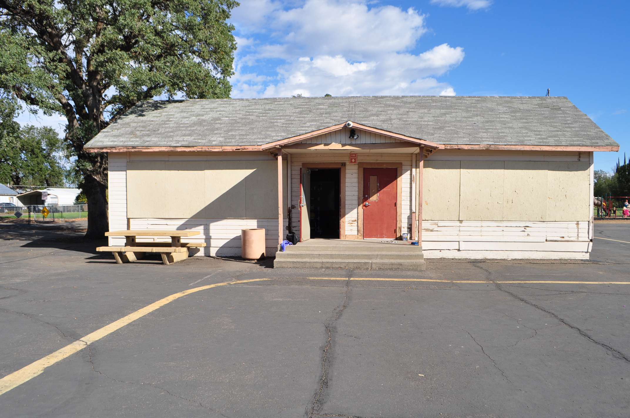

The Kimball Plains schoolhouse at the Cottonwood Creek Charter School in Cottonwood. Photograph taken by Jeremy Tuggle on September 28, 2022. 


Video filmed on location: September 28, 2022.


The Kimball School District was established on August 5, 1879, at Kimball Plains, a small agricultural community west of Cottonwood. That year, a schoolhouse was built for the community which was the only schoolhouse within the Kimball School District. Then in September of 1894, the Kimball Plains Schoolhouse caught fire and burned down. After the fire, the students were transferred to the Cottonwood school to advance their education. Years later, the Kimball School District was re-established on November 14, 1916, after a new schoolhouse was erected for their community that year. This school was located on the north side of Gas Point Road just east of Dry Creek and it was their second and last schoolhouse. The school closed down due to poor attendance and by 1947 or 1948 the entire schoolhouse building was relocated to Cottonwood and placed on another's school's property where it was utilized as an additional building of that school and remodeled. The school property which this 1916 clapboard style structure is located on is currently the home of the Cottonwood Creek Charter School in Cottonwood. The building is saved from demolition, but the Cottonwood Creek Charter School is looking to restore the building to its original condition sometime in the future. Special Thanks to Mark Boyle, Director of Cottonwood Creek Charter School in Cottonwood, California. Historical images provided by the Shasta Historical Society and Mark Boyle.

Link to Kimball Plains article by Jeremy M. Tuggle as mentioned in the above YouTube video: here

RESOURCES:


Our Schools - The Shasta Courier newspaper of Shasta, March 3, 1883

Cottonwood School Ends Spring Term - The Red Bluff Daily News newspaper of Red Bluff, April 20, 1920

Borrowed Children Keep Shasta School Alive - The Blue Lake Advocate newspaper of Blue Lake, January 31, 1931

School Districts of Shasta County 1853-1955 compiled by Veronica Satorius

Wednesday, September 28, 2022

William Joshua Hammans And The Founding Of Project City


Above: William Joshua Hammans (1876-1937) the founder of Project City wearing his police uniform and badge, next to his vehicle in Redding. From the collection of Jeremy Tuggle.


My paternal great-great grandfather was William Joshua Hammans who was born at Shingletown on May 9, 1876, to Henry Hammans Sr., and Hannah (Moss) Hammans his parents came to Shasta County in 1865, they lived at both Shingletown and at Ludwig’s Bridge west of Cottonwood. He married Charlotte Sarah Kidder on April 23, 1899, at Ono. She was a daughter of Reverend William S. Kidder and Mary Elizabeth (McFarlin) Kidder. Early on, Hammans was a farmer, and a stockman of western Shasta County, who served as a Justice of the Peace of the Ono township from 1908 to 1916. Then he became a police officer in Redding who later served as the 13th City Marshal of Redding, from 1923 to 1926, City Marshals are now known as Police Chiefs. 

Then, William J. Hammans bought land in 1931 near the town of Mountain Gate, and in 1935 William and his son Earl Eugene Hammans erected and operated a restaurant and merchandise store on their property, which they named Midway Associated Service Station and Cafe. In 1937 William and his son Earl started to subdivide the area with the help of W.T. Lanning, a real estate agent. Their subdivision was called the Hammans Tract located on Grand Coulee Boulevard which would also feature commercial frontage as well. People started purchasing from them that year and the area of Midway became a flourishing town later known as Project City. It was Hammans and his son who founded Project City, in Shasta County.


Above: is the Midway Associated Cafe and Service Station, owned and operated by William Joshua Hammans and his son Earl Eugene Hammans. From the collection of Jeremy Tuggle.

William J. Hammans was also an apartment complex owner that owned and operated Hammans' Apartments on Yuba Street, in Redding and, a grocery store in Redding called Hammans' Cash Grocery. Later in life, Hammans was a janitor at local Redding area schools and a prison guard at Folsom State Prison. He died in Chico, Butte County, California, on February 27, 1938, at the age of sixty-two. He is buried in Redding Memorial Park at Redding.

During May of 1938, W.T. Lanning proudly boasted about Project City in an article which appeared in the Searchlight newspaper, of Redding, and stated that his lots would all be located on 50 to 60 foot wide streets. Lanning also told the local media that he would build a lumber yard at Project City to make the demand of lumber sales easier for local residents to assist them in the erection of their future residential and commercial buildings in the area. One of the first commercial buildings erected at Project City was completed by Dr. Donald B. Marchus who was a local physician in the area. This medical facility was the first of its kind here and it remained to be the only medical facility in the Shasta Dam Boomtown region.

At a meeting on April 12, 1939, property owners of the area adjacent to the intersection of Highway 99 and the Kennett road, nine miles north of Redding, voted 38 to 52 that night to call the region "Project City" instead of Hammans which was the other name presented. There was an estimated population of 1,500 persons at that time according to one newspaper article. Over 200 people attended the meeting but only property owners were allowed to vote on the naming of the community. The suggested name of Hammans which would have been named in honor of William J. Hammans lost by four votes. However, a Hammans Voting Precinct was also created for the Project City area as well.

Then on, October 10, 1939, a second class United States Post Office was established at Project City which was located eight miles north of Redding, and one mile east of Central Valley, with the appointment of Howard P. Nelson as the first postmaster for this place. A one room schoolhouse was erected at Project City, that year, by E.J. Phillips. Phillips was then awarded another contract on May 21, 1940, to enlarge the school with a two room addition for a contract of $6,720. Project City saw a large influx of students enroll into the upcoming school year, and the school needed more space to accommodate their students.

Years later on, March 26, 1975, the second class Project City United States Post Office changed to a branch of Central Valley, and still controls the mail for the area today. The Project City branch United States Post Office is located on Cascade Boulevard.


Above: the Project City Market at Project City, near Shasta Dam, California. This photo was taken by J.H. Eastman. Courtesy of David Stuart.


Above: the headstone of William Joshua Hammans (1876-1938) who is buried in the Redding Memorial Park at Redding. This photograph was taken by Jeremy Tuggle on August 1, 2014.


Above: the headstone of Earl Eugene Hammans (1907-1974), a son of William Joshua Hammans and Charlotte Lottie (Kidder) Hammans. His headstone states: "A Founder of Project City". Also buried next to him is his wife Virginia (Dare) Hammans (1915-1998) in the Ono Cemetery at, Ono, Shasta County, California. This photograph was taken July 4, 2018 by Jeremy Tuggle.


Above: the Project City branch U.S. Post Office still exists today on Cascade Boulevard. This photograph was taken by Jeremy Tuggle on August 19, 2022.


Resources: 

Brevities - The Searchlight newspaper of Redding, March 7, 1908

The Searchlight newspaper of Redding, October 3, 1911

Mrs. Leschinsky Buy Big Farm West of Ono - The Shasta Courier newspaper of Shasta, March 17, 1914

The Searchlight newspaper of Redding, January 23, 1915

The Courier-Free Press newspaper of Redding, January 10, 1917

The Courier-Free Press newspaper of Redding, October 16, 1917

W.J. Hammans to Be City Marshal at Opening of Year - The Searchlight newspaper of Redding, December 22, 1922

W.E. Smith Is Marshal - The Searchlight newspaper of Redding, June 17, 1926

W.J. Hammans for Justice of The Peace - The Courier-Free Press newspaper of Redding, June 17, 1926

W.J. Hammans Called Beyond - The Courier-Free Press newspaper of Redding, February 28, 1938

William J. Hammans Rites Held Wednesday - The Courier-Free Press newspaper of Redding, March 2, 1938

The Searchlight newspaper of Redding, May 8, 1938

Project City Selected as Name of Area - The Courier-Free Press newspaper of Redding, April 13, 1939

The Sacramento Bee newspaper of Sacramento, May 21, 1940

Redding Police Department History Project

Oral History of the Hammans Family by Linda (Hammans) Vest by the Honorable Judge Richard B. Eaton

The Hammans Family written by Virginia (Dare) Hammans

The Shasta Dam Boomtown Community Building in the New Deal Era written by Al M. Rocca, 1993, 162 pages. Published by Redding Museum of Art And History Center. ISBN: 1-884055-00-1

The Story of William Joshua Hammans by Jeremy M. Tuggle - The Covered Wagon 2004, pages 91-93, published by Shasta Historical Society. 128 pages. ISSN 0574-3680


Saturday, March 6, 2021

COTTONWOOD IN 1899

Above: these structures were erected in the 1870s and 1880s, and they remain standing in Cottonwood today on the east side of Front Street. Date unknown. From the collection of Jeremy Tuggle.


In 1899, Cottonwood was located eighteen miles south of Redding and seventeen miles north of Red Bluff. It was located on the county line between Shasta and Tehama Counties, and on the California and Oregon railroad which included a busy railroad depot that made it a major shipping location. The town also featured a hostelry owned and operated by A.M. Dunham, a bakery owned and operated by a man with the surname of Moore, a church, livery and feed stables, and a general merchandise store owned and operated by John Pfeifer and W.F. Price. 

T.R. McClabe was the post master at the Cottonwood post office, and he delivered the mail to a town site with a population of 450 people, that year. Cottonwood was also home to the Thatcher Lumber Company which was managed by W.F. Smith, at that time. Local resident, A.B. Gilliland was the physician and surgeon in town as well. Cottonwood continued to thrive into the 20th century  

COTTONWOOD BEFORE 1899:

This community has a long history which dates back to 1846, when Captain John C. Fremont named the nearby creek for the abundance of Cottonwood trees in the area. The town site eventually took it’s name from Cottonwood Creek. During 1850, all of the townsite was located in Shasta County. 

Cottonwood was established on the south side of the creek, the settlement stretched from Ludwig Gulch west of the Red Bluff-Shasta Road to nearly the same distance on the east side. The town’s first post office was established in 1852. When Tehama County was created in 1856, Cottonwood Creek was selected as the towns northern boundary which made Cottonwood a two-county town.


Above: the same row of historic structures located on the east side of Front Street on September 6, 2020. This photo was taken by Jeremy Tuggle.


RESOURCES:

1899 City Of Redding Directory

1900 U.S. Census

Shasta County, California A History by Rosena Giles, published by Biobooks, ©1949.

U.S., Appointments of U.S. Postmasters, 1832-1971

Tuesday, February 23, 2021

California & Oregon Railroad Historic Water Tower Foundation of 1872

On June 15, 1872, the town of Redding was established by the California & Oregon Railroad, a division of the Central Pacific Railroad, which stopped the construction of its tracks later that year at Poverty Flats. Poverty Flats lacked settlement by the early European-American’s because it was mainly swampland and farmers couldn’t raise their crops there which is the main reason it was ignored by them. Due to the railroad it forced Redding's settlement upon Poverty Flats. Redding gained prominence and grew rapidly as the town burgeoned with success.

A water tower was built by the California and Oregon Railroad in 1872. It was a very significant structure in Redding. Then on, September 1, 1872, the first passenger train arrived in Redding via Red Bluff, Cottonwood, and Anderson., and later other trains followed suit often refilling their engines with water from this tower. It is located at the Southwest corner of the tracks at the South Street crossing. It's unknown to me when the railroad dismantled it. Everyone has probably driven past it, stopped at it, or walked by it without realizing the historical importance of this foundation. 


Above: The California & Oregon Railroad Historic Water Tower Foundation of 1872. This photograph was taken on June 12, 2020, by Jeremy Tuggle.


Wednesday, April 1, 2020

KIMBALL PLAINS


Above: Major Gorham G. Kimball a co-owner of the Cone & Kimball Company of Red Bluff, Tehama County, California. From the Red Bluff Daily News newspaper edition of Red Bluff, December 22, 1904.


Kimball Plains was one of the smaller settlements of the Bald Hills in western Shasta County, which was located seven miles west of Cottonwood. Business partners, Joseph S. Cone and Major Gorham G. Kimball, of Tehama County, were the first owners of the tract of land which the community was developed on. Originally, the settlement started as a stock range for grazing purposes. This settlement was possibly named after their flock tender, William Kimball, no relation to Major Gorham G. Kimball.

Cone & Kimball soon discovered their land to be extremely valuable to new settlers who wanted to purchase the land for farming purposes. After many offers, the land was sold to a number of newcomers during the latter part of the 1870s. The first residence was located on the south side of Gas Point Road about one mile west of Dry Creek. At this location a water well from that first family still existed when local historian, Myrtle McNamar, published her book Way Back When in 1952.

Three or four families with young children settled, early on, at Kimball Plains which helped the residents establish the Kimball School District on August 5, 1879. Eventually, a one-room schoolhouse was erected in the area. It’s first teacher was A.R. Eldridge. Later, a Baptist congregation was formed in the area and they met inside the Kimball schoolhouse on Sunday morning's. This church was led by my paternal great-great-great grandfather, the Reverend William S. Kidder, a resident of Eagle Creek (now Ono).

Kimball Plains lacked a post office to send and receive mail. The nearest post office to this settlement was located at Gas Point. The mail was delivered from there by their postmaster to the local residents of this community. Then in 1882, Major Gorham G. Kimball and a man named J.C. Tyler sold 640 acres of land to woman named Mary Wright who bought the land for grazing purposes. The following year, A.R. Eldridge was still the teacher of this community who enrolled thirty-seven students at that time into his class.

In April of 1885, the agricultural scene at Kimball Plains changed a little when the discovery of a quartz ledge was made at Kimball's stock range, and the Shasta Courier newspaper of Shasta, reprinted the following article from the Red Bluff Sentinel newspaper of Red Bluff:

"New Discovery - Major Kimball and Will Lunning returned last evening from the Bald Hills country, where they have been for several days surveying the outside lines of the Major's  stock ranch, preparatory to fencing the entire tract. While surveying they ran across a quartz ledge, and knocked off some rock, which they brought with them to be examined by experts and possibly sent to San Francisco  to be assayed. For outside, surface rock, it looks very good, and in fact, native silver can be detected with the naked eye. The rock looks like croppings that come from the Bully Choop mines. The Major further states that frost cooked the leaves on oak trees, and great damage was done to fruits of all kinds. - Red Bluff Sentinel."

Kimball Plains wasn't known as a mining community, but mainly it was settled for agricultural purposes, and when the assessments of the ore returned the ore wasn't as lucrative as Kimball & Lunning hoped for. The mining excitement ceased and it did not create a new boom to the area. During the 1890s, Franz Venzke, a native of Germany, settled at Kimball Plains as a farmer with his wife Sally (Alberg) Venzke.

Then in September of 1894, the Kimball Plains Schoolhouse caught fire and burned down. After the fire, the students were transferred to the Cottonwood school to advance their education. In February of 1901, this excerpt of an article from the Red Bluff Daily News newspaper of Red Bluff reported the following news:

"Within the past few days parties representing two large oil companies from the East, one from Massachusetts the other of Pennsylvania have been trying to secure the sheep range of Major G.G. Kimball, located about thirty miles north-west of this place in what is known as the Bald Hills of Shasta County, and comprising of something like 5500 to 6000 acres for the purpose of boring oil. Their proposition to him, as it was learned, was to sink wells on the place at their own expense and offering him large inducements for the privilege, believing from their experts' opinions that a gusher will be unearthed on these lands."

Just like the earlier mining excitement, this discovery ceased action as well. The Bald Hills didn't produce a lucrative oil strike as it was originally opined by the experts. Major Gorham G. Kimball held onto his land, and there was no new boom to the area of Kimball Plains. During that same year, local resident Franz Venzke was remarried to Mary Rockhold. Then in 1912, Venzke's eldest daughter was married at the home of the bride's father at Kimball Plains to William B. Moore. Beside's being a farmer, Franz Venzke, was also a land owner who kept buying numerous pieces of land in the area.

The Kimball School District was re-established on November 14, 1916, after a new schoolhouse was erected for their community that year. This school was located on the north side of Gas Point Road just east of Dry Creek and it was their second and last schoolhouse. In 1920, Mrs. Gertrude Carter was the teacher of the Kimball schoolhouse.

By February of 1920, Franz Venzke had purchased an additional eight hundred acres of land near Gas Point which gave him a total of 2,000 acres in that section of the county. There is also a story which was heralded by the Blue Lake Advocate newspaper of Blue Lake, California about the Kimball school and it describes the following account:

"Borrowed Children Keep Shasta School Alive - Redding (Shasta Co.) Jan. 26., Kimball Plains School District, four miles west of Cottonwood has a $1,500 school house but no children of school age within its boarders. Mrs. Alice Stone, teacher, keeps up the school and saves the district by "borrowing" school children from neighboring districts and taking them to school every day in her automobile. There is a fresh crop of children now under school age, coming up in Kimball Plains district and there will be no trouble another year to maintain the school with the district product." (SIC)

Franz Venzke lived in the area until his death in November of 1946. He is buried in the Cottonwood Cemetery. Two years later, the Kimball schoolhouse closed down due to poor attendance. Today, not much is left of this early settlement. However, Kimball Plains Road just off Gas Point Road retains the name of this former community.


The Kimball Plains schoolhouse at Kimball Plains. Teacher: Inez (Moore) Ruddy with her students, circa 1945. Courtesy of Shasta Historical Society.


RESOURCES:

The Shasta Courier newspaper of Shasta, December 31, 1881

Our Schools - The Shasta Courier newspaper of Shasta, March 3, 1883

New Discovery - The Shasta Courier newspaper of Shasta, April 25, 1885

The Red Bluff Daily News newspaper of Red Bluff, September 29, 1894

Eastern Oil Companies Looking This Way - The Red Bluff Daily News newspaper of Red Bluff, February 22, 1901

Sheep Feed Burned Out - The Red Bluff Daily News newspaper of Red Bluff, July 19, 1901

Major Kimball Answers Summons - The Red Bluff Daily News newspaper of Red Bluff, December 22, 1904

Shasta Couple Marry - The Sacramento Union newspaper of Sacramento, June 25, 1912

Shasta County Ranch Sold - The Sacramento Union newspaper of Sacramento, February 18, 1920

Cottonwood School Ends Spring Term - The Red Bluff Daily News newspaper of Red Bluff, April 20, 1920

Borrowed Children Keep Shasta School Alive - The Blue Lake Advocate newspaper of Blue Lake, January 31, 1931

Way Back When - Myrtle McNamar, published by C.A.T. Publishing of Redding, California, 1952. 282 pages.

School Districts of Shasta County 1853-1955 compiled by Veronica Satorius

History of the State of California and Biographical Record of the Sacramento Valley, California. An Historical Story of the State's Marvelous from its earliest settlement to the Present Time. By Prof. J.M. Guinn, A.M. The Chapman Publishing Company, Chicago, Ill. © 1906

Franz Venzke: Find A Grave Memorial

U.S., Appointments of U.S. Postmasters, 1832-1971

A Journey Through Time: Ono and the Bald Hills by Jeremy M. Tuggle, with an introduction by Al M. Rocca; copyright 2008, published by Preserving Memories, in Charlotte, North Carolina. ISBN Number: 978-0-9742576-8-6

Tuesday, August 14, 2018

MAJOR PIERSON BARTON READING (1816-1868): THE FIRST EUROPEAN-AMERICAN SETTLER IN SHASTA COUNTY


Major Pierson Barton Reading (1816-1868). This Carta de Vista was taken in 1862. Photographer unknown. Courtesy of Shasta Historical Society.


Pierson Barton Reading (pronounced like the color red), was born to Pierson Reading and Charity (Guild) Reading in Hunterdon County, New Jersey on November 26, 1816, and in 1830, Pierson departed New Jersey, leaving his family behind at the age of fourteen to live with his step-uncle Charles B. Green in Madison County, Mississippi. 

Then in 1834, Reading begins his career as a cotton broker in Madison County. Three years later, at the age of twenty-one, he goes broke due to the price of cotton crashing at the market. Pierson eventually returns to his family in New Jersey. According to the Reading family lore, and local historians, Pierson marries for the first time even though his first wife’s name is unknown but apparently during their short union a daughter was born to them on August 7, 1842, and they named her Jeanette "Janette” Reading, Jeanette was born in Louisiana. At a later date, he leaves his wife and daughter behind in Louisana for Missouri and Reading eventually becomes divorced.

However, according to my friend David L. Templeman, a great-great grandson of Pierson Barton Reading and Euphan “Fannie” Wallace (Washington) Reading. Templeman claims the following about the presumed first marriage of Major Pierson B. Reading:

"There is absolutely no record of a first marriage. There is a story of Janette's mother dying of yellow fever while in New Orleans, when Janette was a baby. Yet no grave or record can be found. I can only imagine Janette's actual mother was not married to Pierson B. Reading. Perhaps a house servants baby. The spelling of her name is French, which aligns with the New Orleans origin story. Unfortunately, a crew of excited historians spent a lot of time speculating about Janette's origins and have released a couple of unsubstantiated proposals. All hold little or no merit.

The first myth is that Janette is Pierson B. Reading’s illegitimate half sister, through his father Pierson Reading's affair (which is also unsubstantiated). There is a fraudulent letter floating around, written by the "niece of Janette", claiming there was a whole family born to Pierson Sr. (again this is Pierson B. Reading’s father). My grandmother was convinced it was a fraud, a con artist chasing money. The second myth is that Janette is the illegitimate daughter of a Reading or Green cousin in Vicksburg. Personally I like to believe she is my great-great Aunt, daughter of Pierson B. Reading." Templeman is also a keen researcher into his own genealogy.

In May of 1843, at Westport, Missouri, Reading joined a large party of immigrants ranging between five hundred and seven hundred people who were traveling to Fort Hall, in Oregon. This immigrant group was led by Peter H. Burnett, and they ventured across the plains heading west towards Oregon with 113 wagons which carried the supplies they needed to survive the long trek. At this time, Reading became good friends with another man in the group by the name of Samuel Hensley.

In September of that year, the Burnett party arrived at Fort Hall; it took them five months to complete the trip over the rough and rugged terrain as the adventure west ended. Once the immigrants arrived in Oregon a small number of men decided to leave the Burnett party and continue south into California. This new group formed the Chiles-Walker party, and their destination was Sutter’s Fort. After purchasing the necessary supplies needed to descend into California, they departed Fort Hall on September 16, 1843. Besides Reading, the Chiles-Walker Party included the following men: Charles Bradley, Henry Chase, Isaac Chase, James Chase, Joseph B. Chiles, Captain John Grantt, Samuel J. Hensley, William Martin, Milton McGhee, John Myers, Joseph R. Walker, and Squire Williams. It was Walker who led the party.

On Thursday, October 26, 1843, the Chiles-Walker party arrived in the region of what became Shasta County, after passing over the Sierra Nevada Range. On that day, they reached the landmarks which we know today as Pit River Falls and Burney Falls. After stopping at both sites, they continued their journey as they encountered numerous Native Americans along the way, who lived in semi-subterranean homes, they knew the white men were in the area but they avoided them. Eventually, Reading saw his first glimpse of his future home, the Rancho Buena Ventura, and then they continued heading south with his party. California at that time was controlled by Mexico. It was Hensley who suggested to Reading that he should obtain a land grant from the Mexican government for this particular area that they were passing through. On Friday, November 10, 1843, they reached Sutter's Fort (or Fort Nueva Helvetia) owned by Captain John A. Sutter.

In 1844, Pierson applied to receive the above property. Reading’s application for the land grant was signed off by Mexican Governor, Manuel Micheltorena on December 4, 1844. This land grant consisted of 26,632.08 acres of land, which extended from the south at Cottonwood Creek and to the north at Salt Creek in Redding. The grant also stretched three miles west of the Sacramento River. He named his land grant the Rancho Buena Ventura meaning “good fortune” in Spanish. In order to obtain his Mexican land grant Reading had to denounce his American citizenship and become a full-fledged Mexican citizen. This is why most American immigrants in California did not apply for land grants under the Mexican government at that time.


A map of the Rancho Buena Ventura land grant owned by Major Pierson Barton Reading. 


The Rancho Buena Ventura became the second land grant in what is now Shasta County. The first land grant was located on the east side of the Sacramento River which was called the Rancho Buena De Briesgau. It was comprised of 22,000 acres of land, and it was William Bennitz who applied for this land grant which was granted to him on July 26, 1844, by Governor Micheltorena. Bennitz was a native of Breisgau, Germany, which is why his rancho was named De Breisgau. However, Bennitz never settled on his property and due to this reason it was never recognized as an official land grant by the Supreme Court of the United States. Then in, September of 1845, Reading joined the United States military to enlist into the Bear Flag Revolt. He enlisted into John Freemont’s battalion as a Paymaster. Reading worked himself through the ranks and he was eventually promoted to the rank of Major.

During the following year, Pierson becomes an active supporter of the settlers revolt to turn California into a State of the Union and on June 14, 1846, a group of American immigrants and ex-patriots marched on Vallejo’s post in Sonoma to successfully over throw the Mexican Government and they declared Reading’s closest neighbor William B. Ide as President of the new Republic of California.

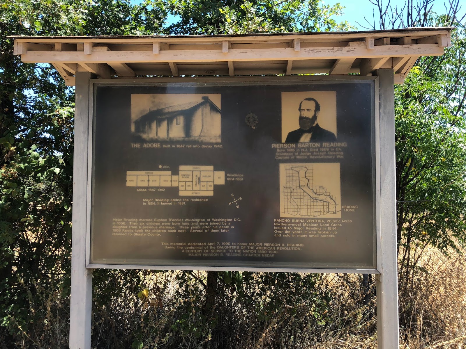
In 1847, Major Reading returned to live on his Rancho Buena Ventura permanently and he erected an adobe house. Reading became the first permanent white settler of what is now, Shasta County, at that time. (His Adobe House fell to vandals in 1942, but it’s listed on the National Register of Historic Places and is California Historical Landmark No. 10)

It wasn’t long before gold was discovered in California by James Wilson Marshall on January 24, 1848, at Coloma on the American River in a tailrace of a sawmill owned by Marshall and John Sutter. After the reports were confirmed that Marshall found gold, it sparked the California Gold Rush and the rush for riches began as new people arrived in California to search for gold. These new arrivals in California would soon be known as forty-niners.

Major Reading took a trip south to the site where Marshall made his discovery and he noted the same red clay on the property and he determined that it was possible that gold could be found on his own property, or at least near it. Then on March 18, 1848, with the help of the Wintu Tribe of Native Americans, Major Pierson B. Reading discovered gold in Clear Creek at what is now known as Reading's Bar, making the second gold discovery in California. Miners would soon descend upon the Rancho Buena Ventura prospecting for gold and squatting on Major Reading’s property, and placer mining erupted along the creek channels.

While prospecting for gold these miners formed tent communities, and the following are the earliest known communities, which were established in 1849: Churntown, Cottonwood, Horsetown, Lower Springs, Middle Creek, and Reading Springs (Shasta). The first community which was established in what is now Shasta County was Cottonwood. In 1848, Major Reading co-established a general merchandise store with Samuel Hensley in Sacramento which was called Hensley, Reading & Company. The firm only lasted for two years when the partnership dissolved in 1850.

Two years after the advent of the California Gold Rush the Rancho Buena Ventura contained the following livestock: 210 horses, 10 mules, 15 cows, and 30 oxen. Major Reading led a prosperous life in California on the western frontier. Then on, February 18, 1850, the County of Shasta was created as one of the original twenty-seven counties of California. It wasn’t until September 9, 1850, that California was admitted into the Union as the 31st State. Major Reading’s adobe residence became the county seat of Shasta County on, February 10, 1851, it was used for court proceedings and the housing of court related documents but government business was never held there.


Pierson B. Reading of Shasta for Governor. A political advertisement from the Daily Union newspaper of Sacramento, June 7, 1851.


Six months later on, August 15, 1851, Major Pierson B. Reading, Dr. Oliver M. Wozencraft and Captain McWhinney establishes the Treaty of Peace and Friendship at the Rancho Buena Ventura with the surrounding Indian tribes. With this treaty they were hoping the Indians would become friendlier towards the white settlers. It became one of 18 peace treaties which was never ratified by the American Government.

Then on, September 3, 1851, Major Reading runs for the office of Governor of the State of California on the Whig ticket in the gubernatorial election. Reading loses the election to Democratic opponent John Bigler who led the election with 441 votes. Bigler became California’s third Governor. At a later date, Pierson meets a gentleman in San Francisco who told him that he was ordered to toss out some 4,000 votes to help arrange Bigler’s victory in the election.

Due to Pierson’s interest in the local Native American tribes he was appointed by Congress to become the Superintendent of Indian Affairs for California on June 18, 1852. Then between: 1853-1854, Pierson promoted a survey of the Noble’s Pass route for a wagon road and with a  group of businessmen from Shasta, contributed $2,000 to send Hamden Holmes Noble back over the route he discovered in 1851. Major Reading also encouraged and supported the construction of the California-Oregon Stage Road. (It is currently California Historical Landmark No. 58.)

Prior to 1855, a man named Richard Bland Lee II was stationed as a Lieutenant at Fort Reading on Cow Creek in Shasta County. Lee became great friends with Pierson and he became a frequent visitor to the Rancho Buena Ventura. It was Lee who persuaded Reading to pursue his niece Euphan “Fannie” Wallace Washington since he was planning a future trip to Washington D.C., where she lived. Fannie was a nickname she was often called by her close family and friends. She was born in September of 1831 to Anna Matilda (Lee) Washington and Doctor Bailey Washington III., at Washington D.C., she was an elegant young lady.

The main reason for the trip east was to check the legal status of his land grant. It was during December of 1855, when Reading traveled east towards Washington D.C., and upon his arrival he immediately began courting Fannie. While Reading was checking his status of ownership of the Rancho Buena Ventura land grant, the Supreme Court of the United States approved his ownership on January 11, 1856. The patent was signed by President, Franklin Pierce. Reading’s trip east was a double success because his land grant was confirmed and a wedding date was decided by Pierson and Fannie.

Then on, March 13, 1856, they were married in Washington D.C., by the Reverend George Cummins at the Trinity Episcopal Church. On this day, a gift was presented to Pierson by Elizabeth (Collins) Lee who was the maternal grandmother of Fannie. It was Elizabeth who told Pierson that he reminded her of President George Washington and then she presented Reading with a lock of the president’s hair of whom the Lee & Washington families were related too. A month later on, April 5, 1856, Mr. and Mrs. Reading departed New York to take his bride west to California crossing the Isthumus of Panama while they made their way towards San Francisco.

While aboard the steamer James L. Stephens, Fannie became sea sick, and the newlyweds reached San Francisco on May 4, 1856, once they reached land Fannie began feeling a lot better. At San Francisco, they checked into the Oriental hotel. They stayed in the city for a while before they resumed their journey north to Shasta County were here they arrived at the Rancho Buena Ventura on May 12, 1856. This was the first glimpse of her husband’s property that Fannie saw that day. Fannie was now among the early pioneer women of Shasta County, she would start writing letters home to her family about her “western” adventures on the frontier of California.


Eupan "Fannie" Wallace (Washington) Reading (1831-1918). Circa 1860s, the photographer is unknown. Courtesy of Shasta Historical Society.


The adobe house which Pierson built in 1847 was too small for him and Fannie to raise a family together so during the year 1856 he added onto the adobe structure by erecting a two-story building. It was a wood framed structure that contained eight rooms. Pierson never referred to it as a mansion but local residents dubbed it the “Reading Mansion”.


The Reading Mansion appears here in this sketch by Alice M. Reading, a daughter of Major Pierson B. Reading. The adobe on the right is the original structure which was built in 1847 by Reading. The 2-story house was attached in 1856 after his marriage took place. The house contained 8 rooms and it burned down in 1881. The adobe fell into decay in 1942. Courtesy of Shasta Historical Society. 


Euphan “Fannie” Wallace (Washington) Reading would eventually bear Pierson six children between the years 1857 and 1865, respectively. Those children were the following:

1. Anna Washington Reading (1857-1906)
2. Alice Matilda Reading (1859-1939)
3. Pierson Barton Reading Jr. (1861-1862)
4. Richard Washington Reading (1863-1925) [twin]
5. Robert Lee Reading (1863-1918) [twin] {actually lived in Shasta County, civil engineer of Shasta County}
6. Frances Collins “Fannie” Reading. (1865-1888)

During the interim, of the above births of their children, in January of  1862, the Original Williams & Kellinger Gold, Silver & Copper Mining Company was incorporated at Copper City with $75,000 divided into 300 shares of $250 each. There principal stockholders were the following people: J.J. Bell, John Kellinger, Major Pierson B. Reading, Dr. George Silverthorne M.D., Charles Williams, and Hogue Worley. Copper City was located on the Squaw Creek, about thirty miles north-east of Shasta. The above company owned and operated the Williams and Kellinger mine located on Kellinger Hill (now Killanger Peak). It was a mine discovered by Charles Williams, but the hill it was located upon was named after his mining partner John Kellinger.

Major Reading had a vision to navigate Steamboats up the Sacramento River north of Red Bluff to Clear Creek between: 1850 and 1860. His dream never became a reality, however, between the years: 1863 and 1864, Pierson establishes a town called Latona in Shasta County as the head of WHOA Navigation to bring steam boats up the Sacramento River. The meaning behind WHOA Navigation defines it as being a slang phrase to describe Shasta in the 1850s. Shasta was the end-of-the-line on the wagon road. Major Reading hired Colonel William Magee to survey this four hundred acre town site for him. Latona was named after a Greek goddess.

During 1864, Pierson engaged himself into mining activities with Kendall Vanhook Bumpass. Bumpass was an early day miner and prospector. Pierson and Bumpass owned a mining claim in the Lassen area. This mining claim turned chaotic with deep pockets of lava flow in which Bumpass lost his leg and he had to have it amputated. Today this mining claim is known as “Bumpass Hell” and it is now located in Lassen National Park.

The esteemed pioneer, Major Pierson Barton Reading, died on his Rancho Buena Ventura land grant on May 28, 1868, at the age of fifty-two years. He was buried in the Reading Family Cemetery on Adobe Road in Cottonwood where other members of his family are interred at this location. Fannie survived her husband another 50 years until she died. Fannie remained on the Rancho Buena Ventura for another three years until she relocated in the east where she settled at Alexandria, Virgnia, in 1871. She made another move in 1878 from Alexandria to Washington D.C., where the pioneer died on May 4, 1918.

There are currently nine historically important sites in Northern California which are dedicated to the memory Major Pierson Barton Reading:

1. Reading’s Bar in Shasta County on Clear Creek, located south west of Redding is named for Major Reading. This is where gold was discovered by Major Reading on March 18, 1848.

2. Reading’s Bar in Trinity County near Douglas City is named for Major Reading. Reading made the first discovery of gold in that county as well in 1848 at the mouth of Reading Creek.

3. Reading Creek in Trinity County is named for Major Reading.

4. Reading Springs (a creek) in the town of Shasta is named for him. (Note: the town of Shasta was formerly called Reading Springs before June 8, 1850, when the town was renamed Shasta by Armstead C. Brown who named it because it was the closest town to Mount Shasta, at that time. Mt. Shasta was in the original boundaries of Shasta County. Siskiyou County wasn’t established until 1852.)

5. Reading Island on the Sacramento River just below the bluff of the Reading Adobe in Cottonwood is named for Major Reading. Due to the channel of the Sacramento River changing, this island is no longer in existence.

6. Fort Reading which was established on May 26, 1852, along the west side of Cow Creek in Shasta County, was named for Major Pierson B. Reading.

7. Reading Rock on the Pacific Ocean is named for Major Reading, it is located near Orick, Humboldt County, California.

8. Reading Peak in Lassen Volcanic National Park was named in honor of Major Pierson B. Reading in 1943.

9. The Reading Family Cemetery is named in honor of Major Reading’s family who is buried there on Adobe Lane in Cottonwood.


Above: the present site of Major Reading's adobe on Adobe Lane in Cottonwood. The adobe fell into decay in 1942. This photograph was taken by Jeremy Tuggle on July 8, 2018.


Above: the original Reading Adobe monument at the present site of Major Reading's adobe on Adobe Lane in Cottonwood. This photograph was taken by Jeremy Tuggle on July 8, 2018.


Above: a newer sign with photographs helps record the history of the Reading Adobe on Adobe Lane at Cottonwood. This photograph was taken by Jeremy Tuggle on July 8, 2018.


Above: the location of Reading's Bar. This photograph was taken by Jeremy Tuggle on July 8, 2018.


Above: the entry way into the Reading Family Cemetery where Major Pierson Barton Reading is buried, its located on Adobe Road in Cottonwood. This photograph was taken by Jeremy Tuggle on July 8, 2018.


The Reading Family Cemetery where Major Pierson Barton Reading is buried with members of his family, its located on Adobe Road in Cottonwood. This photograph was taken by Jeremy Tuggle on July 8, 2018.


RESOURCES:


My Playhouse Was A Concord Coach, an anthology of newspaper clippings and documents relating to those who made California history during the years 1822-1888, by Mae Hélène Bacon Boggs. Published by Howell-North Press ©1942

Shasta County, California A History by Rosena Giles, published by Biobooks, ©1949.

Man Of Destiny Pierson Barton Reading Pioneer of Shasta County, California by Helen S. Giffen, edited by Eleanor Lee (Reading) Templeman, published by Shasta Historical Society, © 1985.

The Journal of Pierson Barton Reading Overland to California, 1843, by Madge Richardson Walsh, ©2003 published by the Association for Northern California Historical Research.

RP-004 - Reading, Pierson Barton Pioneer Plaque File on file at Shasta Historical Society.

Mining Corporations – The Shasta Courier newspaper of Shasta, May 16, 1863

Death of Major Reading - The Shasta Courier newspaper of Shasta, May 30, 1868

Died - The Shasta Courier newspaper of Shasta, May 30, 1868

Funeral - The Shasta Courier newspaper of Shasta, June 6, 1868

Pioneer Woman Called Beyond At Washington - The Courier-Free Press newspaper of Redding, May 6, 1918

An E-mail Correspondence - Subject: Jeanette Reading dated August 9, 2018 between David L. Templeman and Jeremy M. Tuggle, filed in the RP-004 Reading, Pierson Barton Pioneer Plaque File on file at Shasta Historical Society.