

In this episode of Exploring Shasta County History, join Robert Frazier, host of California Unearthed, and I as we hike a historic water ditch that was built in 1855. This water ditch was to give the local mines near Oak Bottom their water to be used in their extraction of ore, and other purposes as well. Come learn some of the history of the area in video as well. Filmed on location: May 3, 2025. Like, comment, and please share subscribe if you haven't yet.
Subscribe To

 Posts
All Comments
Posts
All Comments
Showing posts with label Whiskeytown. Show all posts
Showing posts with label Whiskeytown. Show all posts
Friday, May 9, 2025

Tuesday, November 19, 2024
(OLD) HIGHWAY 299 EAST & WEST ALLIGNMENT BETWEEN WHISKEYTOWN AND THE TOWERHOUSE HISTORIC DISTRICT.
Filmed on location November 2, 2024.
Come explore the following sections of (Old) Highway 299 east and west alignment between Whiskeytown and the Towerhouse Historic District, of Shasta County, California. This highway route was formally a stage road established in 1854, and later a toll road called the Shasta to Weaverville Road or Weaverville to Shasta Road pre-1872 or after the establishment of Redding it was called the Redding to Weaverville Road or Weaverville to Redding Road. In 1934 this historic route became Highway 299 east and west and parts of this route were later decommissioned about 1963.
Resources:
Shasta - The Sacramento Daily Union newspaper of Sacramento, April 13, 1852
Shasta - The Sacramento Daily Union newspaper of Sacramento, June 14, 1852
California Legislature - Fifth Session - The Sacramento Daily Union newspaper of Sacramento, April 15, 1854
Trinity River Correspondence - The Shasta Courier newspaper of Shasta, May 20, 1854
From Weaverville - The Shasta Courier newspaper of Shasta, January 6, 1855
Trinity River Correspondence - The Trinity Journal newspaper of Weaverville, February 17, 1855
Trip To Weaverville - The Shasta Courier newspaper of Shasta, October 13, 1855
Report of the Wagon Road Committee - The Trinity Journal newspaper of Weaverville, June 20, 1857
Organization Of The Wagon Road Co. - The Trinity Journal newspaper of Weaverville, June 27, 1857
Wagon Road Meeting And Report Of Survey - The Trinity Journal newspaper of Weaverville, July 25, 1857
Proceedings of the Board of Supervisors - Aug. Term - The Trinity Journal newspaper of Weaverville, August 8, 1857
Wagon Road Meeting - The Trinity Journal newspaper of Weaverville, August 15, 1857
The Wagon Road - The Trinity Journal newspaper of Weaverville, August 15, 1857
The Trinity Wagon Road - The Shasta Republican newspaper of Shasta, August 22, 1857
Weaverville Wagon Road - The Sacramento Union newspaper of Sacramento, September 1, 1857
Hurrah For The Wagon Road - The Trinity Journal newspaper of Weaverville, October 3, 1857
Wagon Roads - The Sacramento Daily Union newspaper of Sacramento, October 16, 1857
The Sacramento Valley And Weaverville Wagon Company - The Shasta Republican newspaper of Shasta, October 16, 1857
Shasta And Our Neighbors - The Trinity Journal newspaper of Weaverville, November 7, 1857
The Wagon Road - The Trinity Journal newspaper of Weaverville, November 28, 1857
Progress Of the Wagon Road - The Trinity Journal newspaper of Weaverville, December 26, 1857
Trinity Wagon Road - The Trinity Journal newspaper of Weaverville, February 6, 1858
Wagon Road To Weaverville - The Shasta Courier newspaper of Shasta, March 27, 1858
Improvements As We Go - The Trinity Journal newspaper of Weaverville, March 27, 1858
The Trinity Wagon Road - The Shasta Courier newspaper of Shasta, January 2, 1858
The Road - The Shasta Republican newspaper of Shasta, January 16, 1858
The Louden Road - The Shasta Republican newspaper of Shasta, March 13, 1858
Increased Travel To The North - The Trinity Journal newspaper of Weaverville, September 11, 1858
Staging To Weaverville - The Shasta Republican newspaper of Shasta, April 24, 1858
Trail To Weaverville - The Shasta Courier newspaper of Shasta, April 24, 1858
To Weaverville - The Shasta Courier newspaper of Shasta, May 1, 1858
Teams To Weaverville - The Shasta Republican newspaper of Shasta, May 15, 1858
A Bad Road - The Shasta Republican newspaper of Shasta, November 20, 1858
Bill Lowden declares... - The Trinity Journal newspaper of Weaverville, December 18, 1858
The Redding And Weaverville Stage - by May H. Southern, January 22, 1933, sketch by Mabel Lowden Moores, 388 - P. 1086; VF 388.0 Roads/Trails Misc., Roads/Trails 1086, available at Shasta Historical Society in Redding.
My Playhouse Was A Concord Coach, an anthology of newspaper clippings and documents relating to those who made California history during the years 1822-1888, by Mae Hélène Bacon Boggs. Published by Howell-North Press ©1942
Shasta County, California A History by Rosena Giles, published by Biobooks, ©1949
Historic Resource Study Whiskeytown National Recreation Area by Anna Coxe Toogood, May 1978, Denver Service Center, Historic Preservation Team, National Park Service, United States Department of the Interior
Whiskeytown National Recreation Area, by Al M. Rocca, Publisher: CreateSpace Independent Publishing Platform (May 3, 2010) ISBN10: 1451568533,ISBN-13: 978-1451568530
Monday, August 12, 2024
Mountain View Cemetery in Oakland, California, the Shasta County Connections, the Famous and the Historical Figures.
This documentary starts with local Shasta County, California, pioneers, which continues to cover some of the nationally renowned famous people, as well as some of the historical figures buried within this amazing 226-acre cemetery. Journey with me as we explore the Mountain View Cemetery in Oakland, Alameda County, California, which was established in 1863. From murder victim Elizabeth Short also known as the Black Dahlia, to legendary Oakland rapper Mac Dre, and then to Major League Baseball Hall of Famer, Ernie Lombardi, is just a small portion of the famous people buried here. Among the millionaires are Domenico Ghirardelli and Charles Crocker, who are both historical figures like James A. Folger, and Henry G. Blasdell. Come find out about the life these famous and historical people led.
Video filmed on location July 31, 2024.
Saturday, December 23, 2023
Tower House Historic District Abandoned Mine: A Stope & An Ore Pass
Ever climbed up an ore pass of an abandoned mine before? Not too many people have. An ore pass is a vertical or inclined passage for the downward transfer of ore connecting to a lower level of a mine connecting with an ore chute/ore shoot. We were expecting this mine to be plugged or gated within the boundaries of the Tower House Historic District near Whiskeytown, California, but it was wide opened, so we didn't bring a hard hat. This mine is one of those abandoned treasures which don't appear on any topography maps of the region and doesn't have a recorded history of it. Inside the mine you'll see a small stope as well which my friend Ryan Hammon and I discovered.
Filmed on location December 16, 2023.
Friday, April 7, 2023
Oak Bottom

The town of Oak Bottom and the two-story Oak Bottom Hotel. Date unknown. This photograph was taken by local photographer Chester Mullen (1886-1958). Courtesy of Shasta Historical Society.
The Fortunate township was established by the Shasta County Court of Sessions in 1851 as a townsite which lacked a United States Post Office. It was a prominent mining locality. This township was situated two miles north-west of Whisky Creek Diggings, (now Whiskeytown), along the Oregon Trail which passed through the area. It was a designated stopping place for pack mules along that route. It's not known how the Fortunate township received its name, but in 1853, the Fortunate township became the Oak Bottom election precinct, which was one of twenty-two election precincts established in Shasta County, that year.
Since then, the townsite has been known as Oak Bottom and named for the numerous Oak trees in the area. A two-story hotel began operations in 1853 which was called the Oak Bottom House a popular hostelry within the community. This hotel was owned and operated by A.J. Van Wie. In 1858, the Oak Bottom Course came to fruition under the ownership of Heavins and McTurck, and horse racing became an extremely popular sporting event within the community.

Above: an advertisement by Heavins & McTurck for their Oak Bottom Course at Oak Bottom. From the Shasta Courier newspaper of Shasta, December 4, 1858.
That year, Heavins and McTurck also took over operations of the local hostelry. The Oak Bottom House was destroyed by fire in 1873. The Oak Bottom hostelry was later rebuilt on the opposite side of the road and the name was changed to the Oak Bottom hotel. The above image showcases the Oak Bottom hotel and an additional building at Oak Bottom, in Shasta County, California.
This locality which never had a United States Post Office to send and receive mail flourished with success until the 1950s. Oak Bottom once featured a general merchandise store owned and operated by C. Vergnes & Company, as well sometimes found as the Vergnes Brothers. The townsite began filling with water for a reservoir called Whiskeytown Lake in 1962 which created the Oak Bottom Marina and beach which is now a popular tourist attraction for water sports, swimmers and sun bathers within the Whiskeytown National Recreation Area.

Above: a ticket for a dance and supper hosted by the Vergnes Bros. Oak Bottom Ticket No. 889. From the collection of Jeremy Tuggle.
Resources:
Election Precincts - The Shasta Courier newspaper of Shasta, September 3, 1853
Banquet At Oak Bottom - The Shasta Courier newspaper of Shasta, March 24, 1855
Local Correspondent - The Shasta Courier newspaper of Shasta, January 2, 1858
Estray - The Shasta Courier newspaper of Shasta, October 9, 1858
Horse-Racing - The Shasta Courier newspaper of Shasta, December 4, 1858
Oak Bottom House - The Shasta Courier newspaper of Shasta, December 11, 1858
Our Storied Landmarks – Shasta County, California, written by May H. Southern, published by Balakshin Printing Company, ©1942.
My Playhouse Was A Concord Coach, an anthology of newspaper clippings and documents relating to those who made California history during the years 1822-1888, by Mae Hélène Bacon Boggs. Published by Howell-North Press ©1942.
Shasta County, California A History, by Rosena Giles, published by Biobooks, ©1949.
Place Names of Shasta County by Gertrude A. Steger revision by Helen Hinckley Jones, ©1966 by La Siesta Press, Glendale, California
Historic Resource Study Whiskeytown National Recreation Area by Anna Coxe Toogood, May 1978, Denver Service Center, Historic Preservation Team, National Park Service, United States Department of the Interior
Whiskeytown National Recreation Area, by Al M. Rocca, Publisher: CreateSpace Independent Publishing Platform (May 3, 2010) ISBN10: 1451568533,ISBN-13: 978-1451568530
Tuesday, December 20, 2022
A Christmas Ball at the Whiskeytown Hotel in 1861

Above: an advertisement for the main event on Christmas Day, at Whiskeytown in the Whiskeytown hotel. From the Shasta Courier newspaper of Shasta, December 21, 1861.
On Christmas Day, in 1861, a grand Christmas celebration was opened to the public to celebrate Christmas at Whiskeytown inside the Whiskeytown hotel, on December 25th, hosted by the hotel's proprietor George P. McGuire, a local hostelry man. It was a public affair which was managed by various local residents of Shasta and Trinity Counties, yes, even Weaverville and Minersville assisted in organizing this grand ball with our county residents at the time. This grand ball featured an elegant dinner, a live band rendering music, dancing, Christmas presents which were donated by the managers for the children, Santa Claus, and a beautifully decorated Christmas tree. This Christmas, I’m wishing you and your family a very Merry Christmas, and I hope you enjoy all of the numerous festivities of this holiday season with your family and friends.
Resources:
The Shasta Courier newspaper of Shasta, December 7, 1861
The Shasta Courier newspaper of Shasta, December 14, 1861
Christmas Ball At Whiskeytown - The Shasta Courier newspaper of Shasta, December 21, 1861
Tuesday, March 22, 2022
A Hidden Highway Under Whiskeytown Lake?
Filmed on location March 19, 2022.

A low Whiskeytown Lake reveals one of its many hidden secrets as Jeremy M. Tuggle poses in front of it for a photograph on March 19, 2022.
Resources:
Shasta - The Sacramento Daily Union newspaper of Sacramento, April 13, 1852
Shasta - The Sacramento Daily Union newspaper of Sacramento, June 14, 1852
California Legislature - Fifth Session - The Sacramento Daily Union newspaper of Sacramento, April 15, 1854
Trinity River Correspondence - The Shasta Courier newspaper of Shasta, May 20, 1854
From Weaverville - The Shasta Courier newspaper of Shasta, January 6, 1855
Trinity River Correspondence - The Trinity Journal newspaper of Weaverville, February 17, 1855
Trip To Weaverville - The Shasta Courier newspaper of Shasta, October 13, 1855
Report of the Wagon Road Committee - The Trinity Journal newspaper of Weaverville, June 20, 1857
Organization Of The Wagon Road Co. - The Trinity Journal newspaper of Weaverville, June 27, 1857
Wagon Road Meeting And Report Of Survey - The Trinity Journal newspaper of Weaverville, July 25, 1857
Proceedings of the Board of Supervisors - Aug. Term - The Trinity Journal newspaper of Weaverville, August 8, 1857
Wagon Road Meeting - The Trinity Journal newspaper of Weaverville, August 15, 1857
The Wagon Road - The Trinity Journal newspaper of Weaverville, August 15, 1857
The Trinity Wagon Road - The Shasta Republican newspaper of Shasta, August 22, 1857
Weaverville Wagon Road - The Sacramento Union newspaper of Sacramento, September 1, 1857
Hurrah For The Wagon Road - The Trinity Journal newspaper of Weaverville, October 3, 1857
Wagon Roads - The Sacramento Daily Union newspaper of Sacramento, October 16, 1857
The Sacramento Valley And Weaverville Wagon Company - The Shasta Republican newspaper of Shasta, October 16, 1857
Shasta And Our Neighbors - The Trinity Journal newspaper of Weaverville, November 7, 1857
The Wagon Road - The Trinity Journal newspaper of Weaverville, November 28, 1857
Progress Of the Wagon Road - The Trinity Journal newspaper of Weaverville, December 26, 1857
Trinity Wagon Road - The Trinity Journal newspaper of Weaverville, February 6, 1858
Wagon Road To Weaverville - The Shasta Courier newspaper of Shasta, March 27, 1858
Improvements As We Go - The Trinity Journal newspaper of Weaverville, March 27, 1858
The Trinity Wagon Road - The Shasta Courier newspaper of Shasta, January 2, 1858
The Road - The Shasta Republican newspaper of Shasta, January 16, 1858
The Louden Road - The Shasta Republican newspaper of Shasta, March 13, 1858
Increased Travel To The North - The Trinity Journal newspaper of Weaverville, September 11, 1858
Staging To Weaverville - The Shasta Republican newspaper of Shasta, April 24, 1858
Trail To Weaverville - The Shasta Courier newspaper of Shasta, April 24, 1858
To Weaverville - The Shasta Courier newspaper of Shasta, May 1, 1858
Teams To Weaverville - The Shasta Republican newspaper of Shasta, May 15, 1858
A Bad Road - The Shasta Republican newspaper of Shasta, November 20, 1858
Bill Lowden declares... - The Trinity Journal newspaper of Weaverville, December 18, 1858
The Redding And Weaverville Stage - by May H. Southern, January 22, 1933, sketch by Mabel Lowden Moores, 388 - P. 1086; VF 388.0 Roads/Trails Misc., Roads/Trails 1086, available at Shasta Historical Society in Redding.
My Playhouse Was A Concord Coach, an anthology of newspaper clippings and documents relating to those who made California history during the years 1822-1888, by Mae Hélène Bacon Boggs. Published by Howell-North Press ©1942
Shasta County, California A History by Rosena Giles, published by Biobooks, ©1949
Historic Resource Study Whiskeytown National Recreation Area by Anna Coxe Toogood, May 1978, Denver Service Center, Historic Preservation Team, National Park Service, United States Department of the Interior
Whiskeytown National Recreation Area, by Al M. Rocca, Publisher: CreateSpace Independent Publishing Platform (May 3, 2010) ISBN10: 1451568533,ISBN-13: 978-1451568530
Sunday, August 8, 2021
SMOKEY CONDITIONS: WHISKEYTOWN LAKE POOR-UNHEALTHY AIR QUALITY, 8-8-2021.
SMOKEY CONDITIONS: WHISKEYTOWN LAKE POOR-UNHEALTHY AIR QUALITY, 8-8-2021. WITH FOUR MAJOR FIRES BURNING NEAR SHASTA COUNTY WHISKEYTOWN LAKE BECOMES BARELY VISBLE IN PARTS THE FOUR FIRES ARE THE: MONUMENT FIRE, THE DIXIE FIRE, THE ANTELOPE FIRE AND THE McFARLAND FIRE. THIS GIVES WHISKEYTOWN LAKE AND THE REDDING AREA AN AIR QUALITY INDEX OF 181.
Tuesday, July 23, 2019
ONE YEAR ANNIVERSARY OF THE CARR FIRE; REVISITING THE DEVASTATED AREAS & THE HISTORY OF KESWICK

Above: a welcome to Keswick sign, Keswick was established in 1895. The town sign survived the Carr Fire, located at Market Street and Iron Mountain Road. This photograph was taken by Jeremy Tuggle on August 8, 2018.
The historic and deadly Carr Fire erupted into flames around 1:30 p.m., on July 23, 2018 at the intersection of Highway 299 West and Carr Powerhouse Road, due to vehicle malfunction failure. It ravaged everything in its course of destruction in Shasta County as it entered nearby populated places traveling into Shasta. Spot fires were a regular occurrence. On the afternoon of July 26, 2018, some spectators watched from the vista points near Shasta Dam as the Carr Fire climbed over Copley mountain, but the worst was yet to come.
The fire raged into Lower Springs, Keswick and Redding. Eventually, it made its way into other places in the area. It was scary, unlike anything our county has seen before, we weren't prepared for this monster, but our fire fighters and first respondents battled the blaze. Everyone was on high alert, and some evacuations were almost last minute. Pure fear and pandemonium spread over Keswick and Redding when the famous fire whirlwind ravaged them, that night.
The fire kept getting hotter and had its own weather pattern. Then it jumped the Sacramento river, and also made its way south-east to Harlan Drive and the Lake Redding Drive area. Many people were evacuated from their home's including downtown Redding at Chestnut Street. All the hotels and motels were completely booked for many miles by evacuees. Emergency shelters were set up at various places in the county. Traffic in and out of Redding was a nightmare in its own. The Carr Fire grew to become the 6th most destructive fire in California state history and it became the most destructive fire in the history of Shasta County. One hundred percent containment was held on the fire at 229, 651 burned acres on August 30, 2018. Eight lives perished during the deadly fire, a tally of 1,079 homes were destroyed, while another tally of 79 homes were damaged which included the Shasta County Fire Station No. 53 at Keswick, which was a volunteer fire company.
The Carr Fire destroyed the town of Keswick leaving only two residences standing next to each other on separate lots on Weiland Street. However, one of Keswick’s unknown secrets were revealed. The strange metal dome shape structures seen on the property of Alan Crabtree were seen for the first time. They were usually blocked from the view of the public by his buildings on the property and they attracted much attention on Facebook and many people called into the Shasta Historical Society wondering what they were. We didn't know much about them, and yet we could only speculate. Through a mutual friend I was placed in contact with Crabtree and he believes that they were “covers for artillery and people sold surplus from them, years ago.” However, it’s not known exactly what they were originally used for. According to Crabtree the inside of the covers had iron in them.

Above: only two houses survived the Carr Fire which are located on Weiland Street near Bush Street at Keswick. Both houses are shown here in this photograph above. This photograph was taken by Jeremy Tuggle on August 8, 2018.

Above: the residence at 11541 Weiland Street survived the Carr Fire. This photograph was taken by Jeremy Tuggle on August 8, 2018.


Above: the residence at 11557 Weiland Street survived the Carr Fire. This photograph was taken by Jeremy Tuggle on August 8, 2018.

Above: one of the strange metal dome shape structures, possibly used as a cover for artillery, from which people sold surplus from them, years ago. This photograph was taken by Jeremy Tuggle on August 8, 2018.
You could say that history has repeated due to the Carr Fire as it’s not the first time the town of Keswick has been destroyed by fire. The phrase “We will rebuild” which was coined by local residents after the Carr Fire comes to mind, because in past history, it did rebuild after the destruction of those major fires. Today (July 23, 2019), marks the one-year anniversary since the hellish Carr Fire erupted into flames.
THE ESTABLISHMENT OF KESWICK:
Long before the town site of Keswick was established the present town site was bustling in action with horse racing, cock fighting, gymnastic exercises, and additional entertainment purposes for our local residents to enjoy. A horse racing arena called the Oakland Horse Racing Track was established there in 1852 by pioneer T.J. Stump. Stump owned the track until 1856, it was also home to a suburb of Shasta called Hogtown which never took-off and eventually disappeared. Hogtown was located near the Stump Ranch that Stump owned and lived upon.
Stump sold out to Frank Thompson and later owners made extensive changes to the property. The smelter town of Keswick was established in 1895, due to the nearby production of the Iron Mountain mine, which was owned and operated by the Mountain Copper Company LTD., who had purchased the mining property from Charles Camden, Colonel William Magee and James M. Sallee, that year. The mine was located in 1865 by Camden and Magee, and it quickly became known for its mass copper production. The mining property was part of the Shasta County copper belt. Sallee became a partner in 1884, after discovering a lucrative vein of silver in their mine.

Above: the Keswick smelter was the the first copper smelter in Shasta County. It was built between 1895 to March 1896, when one of the first furnaces of the smelter began its operation. It was formerly located on Spring Creek on the site where the Spring Creek Powerhouse is today on Iron Mountain Road. Note: the denuded hill sides from the deadly chemicals of the smelter fumes. Date: unknown. Courtesy of Shasta Historical Society.
While the smelter was being erected upon Spring Creek the first order of business by the Mountain Copper Company LTD., was to erect living quarters for their personnel, and this included the superintendent residences. The living quarters consisted of a one two-story building comprised of sixteen rooms with furnishings which included baths and toilets. This made their staff feel comfortable at home. The company also built a mess hall and a entertainment hall. Construction then followed on two company office buildings.
On October 18, 1895, the Shasta Courier newspaper reported the following:
“Keswick and the camps are booming, locomotives tooting up and down the new track. It’s a regular hive of industry.”
The owner and president of the Mountain Copper Company LTD., was Lord William Keswick of London, England, who the town of Keswick was named for. The Mountain Copper Company, LTD., holdings on Iron Mountain included the following mines on the adjacent properties: the Complex, the Hornet, the Lost Confidence, the Mattie, the No. 8, the Old Mine, and the Richmond.
As the new settlement of Keswick boomed it flourished, even though it was a rough-and-rugged up-and-coming-place to live. The town was primarily established due to the nearby copper smelter which was designed to process the ore from the Iron Mountain mine. Then on, November 23, 1895 the local media offered the following glimpse of the area:
“While the Iron Mountain improvements result in considerable benefit to the country in various respects, the inflow of tough characters, which always follows on the heels of any great enterprise, is bound to cause considerable and public exbense” (SIC)
The settlement also contained thirty-five saloons, a railroad station, stores, boarding houses, hotels and a school. In December of that year, due to the high number of saloons in Keswick the Mountain Copper Company LTD., banned all employees who “patronized the saloons” there. It appeared that they wanted a sober crew of employees who took the job seriously. With that many saloons in operation, one can see that this company had their job cut out for them.
“W.S. Harvey-Wray of Keswick, was a visitor here, Sunday. He is to be assistant editor of Mountain Mine monthly paper, or magazine, to be issued by parties employed with the company. The residing surgeon and physician, Dr. Kenneth Millican, A.B., M.R.C.S., will be chief editor. George A. Poor, the veteran book and job printer of Redding, has the contract to print the periodical, which will be sixteen pages, two columns to a page.” (SIC) The above magazine only operated for a period of six months at Keswsick when it was discontinued by the owners.
A second post office called Taylor was established in the smelter town on May 18, 1897, by the United States Postal Service who appointed John K.O. Hair as the first postmaster. Keswick now had two post offices serving their community. Taylor was the post office and Keswick was the town site. This post office served Keswick until August 15, 1922 when it was discontinued and the mail from the Taylor post office was rerouted to the Keswick post office.
During July of 1897, the third branch store of the McCormick-Saeltzer Company was established in the growing smelter town at the new suburb of Keswick, called South Park. Keswick was attracting attention in the local media, and the firm was offered a room inside the brand-new Keswick hotel or Hotel Keswick at that location by its owner, John N. Stephenson. This store was owned by James McCormick, Rudolph M.F. Saeltzer and Williamson L. Smith who were all local businessmen.

Above: this undated photograph shows the Keswick hotel or Hotel Keswick building which was designed by architects W.J. Bennett and his partner Gove. The hotel was erected by carpenters McCarthy & Gillespie at South Park in Keswick. The Keswick branch of the McCormick-Saeltzer Company's sign is visible on the left side of the building. Courtesy of the Shasta Historical Society and the Siskiyou County Museum.
South Park was booming as new structures were rapidly built by local carpenters. Keswick has had its share of fires but nothing like the Carr Fire. On May 12, 1898, the first fire in the history of Keswick ignited causing $40,000 in damages. It was opined that this fire ignited in the saloon of McCandless & Patterson, however, another account revealed that it started in a boarding house called Our House, due to careless lodger who left a candle burning inside his room. It destroyed nearly half of the business portion of Keswick. The Keswick hotel survived but it suffered a minimal damage of $500. A water brigade battled this fire. Keswick lacked a fire department at that time.
Later reports favored the boarding house fire theory. Keswick also lacked fireproof brick buildings, as the town was entirely made of wood by local carpenters and it still became the target of future fires. In just two years, Keswick contained a thriving population of 1,200 people according to media reports of the era.
The United States Postal Service headquarters in Washington D.C., established a post office called Keswick at that location on January 9, 1896 with Louis Schwichman (sometimes spelled as Schwickman) as postmaster of this new post office. It stayed in business until 1923 when it was discontinued. Then on, February 29, 1896 the Shasta Courier newspaper heralded the following column:
The town had a Methodist Church which was used for their place of worship. Weekly membership meetings were held at the church. In February of 1901, Keswick raised money for improvements to be made on their church building. The expense incurred was $150. It was the Reverend Fay Donaldson who often preached inside this church. The church walls were papered through-out the building, and new baseboards were added, the interior was remodeled at that price during that month.

Above this circa 1900s photograph of Keswick was taken by the Eastman View Company of Kennett. Courtesy of Shasta Historical Society.
In addition to that month, there were many residents who were even talking about the possibility of an electric road to be built between Redding and Keswick, one article mentioned the following excerpt:
"As quickly as the weather will allow the engineer corps will start a line north from Redding to Reid's Ferry where it will cross the river and follow up the stream to the new Keswick bridge. There it will re-cross the river and proceed up the south side of Spring Creek to Keswick. Mr. Johns believes Keswick can be reached by the route in about six miles. The heaviest expense would be the buidling of a bridge at the ferry. At Keswick station the line could cross on an extension built onto the county bridge."
Then on April 20, 1901, fire struck the town of Keswick a second time when flames broke out in the Mascot Saloon, conducted by Cecil & Bray. The origin of this fire was not reported. Once again, the town’s residents kept no fire insurance, even though it had been available to them. The loss was smaller than the 1898 fire, and only did $30,000 in damage, a tally of 20 buildings were destroyed.
Another new feature to Keswick in 1901 was electricity. The Keswick Electric Power Company began generating electricity for the smelter at Spring Creek, and eventually the town of Keswick. The electricity was sent from the Volta Powerhouse on Battle Creek and channeled it towards Keswick,
After those business was re-established by July of 1902 business was booming at Keswick as an influx of shoppers used their stores to purchase goods of all kinds. Later on, another disastrous fire claimed the entire business district of Keswick on November 14, 1907. The fire was started by a “fire bug” according to local media accounts. The entire loss was $60,000, and as usual not one person in town kept fire insurance.
Minimal damage was done to the post office, a butcher shop and a bakery as well. Keswick was still without a fire department and once again the community relied on their own efforts to make containment on the fire. As Keswick emerged out of the smoke, the town laid in ashes. A new post office was re-established as the Keswick post office in 1960. With all these fires occurring in the smelter town, Keswick has shown us over the years that we can rebuild. Additional fires would strike the town site in its future.
Our staff at Shasta Historical Society compiled an inventory of burned up or damaged sites due to the Carr Fire. Our inventory contains twenty-four entries and this listing is available to the public upon request. Most of the historic sites on the list do not include those inside the boundaries of the Whiskeytown National Recreation Area or Shasta State Historic Park however, there are some entries that made the listing.

Above: the Shasta County Fire Station Number 53 sign at Keswick in front of their building was badly burned by the Carr Fire. This photograph was taken by Jeremy Tuggle on August 8, 2018.

Above: the Carr Fire burned the Shasta County Fire Station Number 53 building at Keswick, and property. This photograph was taken by Jeremy Tuggle on August 8, 2018.

Above: an interior view looking in from a window of the building. The Shasta County Fire Station Number 53 at Keswick. This photograph was taken by Jeremy Tuggle on August 8, 2018.

Above: looking inside from a window of the building. The Shasta County Fire Station Number 53 at Keswick. This photograph was taken by Jeremy Tuggle on August 8, 2018.

Above: near the intersection of North Street and Market Street at Keswick. Destruction of the Carr Fire. This photograph was taken by Jeremy Tuggle on August 8, 2018.

Above: a speed limit sign in the town of Keswick burned by the Carr Fire as well as the property around it. This photograph was taken by Jeremy Tuggle on August 8, 2018.

Above: at the intersection of Bush Street and Center Street at Keswick. Destruction of the Carr Fire. This photograph was taken by Jeremy Tuggle on August 8, 2018.

Above: the intersection of School Street and Bush Street at Keswick. Destruction of the Carr Fire. This photograph was taken by Jeremy Tuggle on August 8, 2018.

Above: a house in Keswick totally destroyed by the Carr Fire. This photograph was taken by Jeremy Tuggle on August 8, 2018.

Above: another house and property destroyed by the Carr Fire in Keswick. This photograph was taken by Jeremy Tuggle on August 8, 2018.

Above: devastation from the Carr Fire in Keswick. This photograph was taken by Jeremy Tuggle on August 8, 2018.

Above: a sign at Keswick: "WARNING: ASH & DEBRIS MAY BE HOT AND CONTAIN HAZARDOUS MATERIALS." This photograph was taken by Jeremy Tuggle on August 8, 2018.

Above: fire fighters on duty at Keswick. This photograph was taken by Jeremy Tuggle on August 8, 2018.

Above: a private residence destroyed by the Carr Fire at Keswick. This photograph was taken by Jeremy Tuggle on August 8, 2018.

Above: near the intersection of School Street and North Street at Keswick. Devastated area. This photograph was taken by Jeremy Tuggle on August 8, 2018.

Above: the U.S. Mail boxes along Main Street at Keswick badly burned. This photograph was taken by Jeremy Tuggle on August 8, 2018.

Above: at Keswick, burnt vehicles, power lines in the distance. This photograph was taken by Jeremy Tuggle on August 8, 2018.
W.S. Harvey-Wray – The Shasta Courier newspaper of Shasta, February 29, 1896.
The Smelter Magazine – The Shasta Courier newspaper of Shasta, September 12, 1896
Fire At Keswick – The Sacramento Daily newspaper of Sacramento, May 13, 1898
Keswick Partially Destroyed By Fire – The San Francisco Call newspaper of San Francisco, May 13, 1898
RISING FROM THE RUINS – The Daily Free Press newspaper of Redding, June 14, 1898.
Flames Sweep Smelter Town – The San Francisco Call newspaper of San Francisco, April 21, 1901
New Route For Electric Line - The Free Press newspaper of Redding, February 5, 1901
Keswick Improves Its Worship Place - The Free Press newspaper of Redding, February 8, 1901
Changes At Keswick - The Free Press newspaper of Redding, June 23, 1902
New Keswick Belfry - The Free Press newspaper of Redding, July 12, 1902
New Route For Electric Line - The Free Press newspaper of Redding, February 5, 1901
Keswick Improves Its Worship Place - The Free Press newspaper of Redding, February 8, 1901
Changes At Keswick - The Free Press newspaper of Redding, June 23, 1902
New Keswick Belfry - The Free Press newspaper of Redding, July 12, 1902
Town Burned – The Red Bluff News newspaper of Red Bluff, November 15, 1907
Ffity Years of Operation by The Mountain Copper Company, LTD., in Shasta County California by William F. Kett ©1947, 162 pages. Published by California Division of Mines
Ffity Years of Operation by The Mountain Copper Company, LTD., in Shasta County California by William F. Kett ©1947, 162 pages. Published by California Division of Mines
Shasta County, California A History by Rosena Giles, published by Biobooks, ©1949.
The Covered Wagon 1949, publishes by Shasta Historical Society.
The Covered Wagon 1954, publishes by Shasta Historical Society.
Place Names of Shasta County by Gertrude Steger, published by La Siesta Press, ©1966.
Mines and Mineral Resources of Shasta County, ©1974, Philip A. Lyden & J.C. O'Brien
The Covered Wagon 1996, published by Shasta Historical Society.
U.S., Appointments of U.S. Postmasters, 1832-1971
UPDATE: Carr Fire now most destructive in Shasta County history, by Mike Chapman, The Redding Record Searchlight newspaper of Redding, August 3, 2018
Friday, May 31, 2019
Gold Fever: A Tale of the Lost Cabin Mine
The Lost Cabin mine is a fabled gold mine which was located by prospectors Cox, Benedict and Compton during the year 1850, however, the first quartz mines in Shasta County were not dug out and located until 1852, everything up-until-then (in this county) were placer mines. While the three miners were prospecting in the Sacramento River Canyon (where it is believed to have been located) a grizzly bear met them face-to-face. The miners shot and killed the animal which fell into a natural shaft about several feet in diameter. One of the men jumped into this depression in the ground to cut the meat from the grizzly bear for food.
While he was carving out the meat from the grizzly bear, he noticed a gold nugget in the shaft and he stopped cutting meat to continue to prospect this natural hole while he moved the large creature around to give him room to make the search. He found additional free gold, and he stopped collecting the nuggets. The three men discussed what to do next and they decided to cut the trees in the area to erect two cabins. Eventually, the two cabins were erected by Cox, Benedict and Compton at the site. They also found a way to lift the body of the grizzly bear out of the hole to clear it out.
Cox, Benedict and Compton, stayed in the area for sometime they had axes with them which helped them build their cabins and blaze a trail to their discovery site. However, within time the fear of the heavy winter months ahead forced them to abandoned this claim. Legend has it that the three men departed the area with $40,000 each. in free gold, a grand total of $120,000. They reached a trading post near Whiskeytown, and showed the people at the trading post their findings which made their story factual and in time legendary. The three men never returned to Shasta County, and the secret of its location went with them until they died.
Then in 1853, John W. Hillman led a party of prospectors into the Sacramento River Canyon in the upper end of the canyon in hopes to locate the fabled Lost Cabin mine, this was before he discovered Crater Lake in Oregon. Their search yielded no results. The men were hoping to find the cabins of the former miners still standing in a non-populated place. Once they found no trace of this fabled site they decided to move north into the Oregon territory.
During 1855, a new rush of miners seeked-out the area of Lower Soda Springs which was the home to Castle Crags. The tale of the Lost Cabin mine was retold by an early pioneer settler of the area named Joe De Blondy alias Mountain Joe who kept a trading post in the area. Mountain Joe had befriended another pioneer in the area by the name Cincinnatis H. Miller alias Joaquin Miller the famed Poet of the Sierra's who also talked about the fabled mine. Mountain Joe thought it would bring him additional business to his trading post, and his business flourished because of it. As more European-American's and other emigrants entered Shasta County the tale became widespread. Thousands of men dotted the creeks and bars on the Sacramento River in search of the fabled mine.
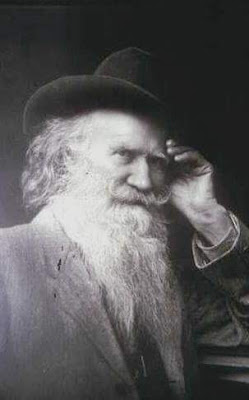
Pictured above: Cincinnatis H. Miller alias Joaquin Miller the famed Poet of the Sierra's. Courtesy of Shasta Historical Society.
Miners began filling the nearby creeks and the Sacramento River with mud from their mining activities which killed the salmon run in these channels. They also began to hunt the wild game in the area which left no food for the Modoc Indians. The Modoc Indians began attacking travelers using the Oregon Trail in response to the European-Americans which forced the closure of that famous route in Shasta County. It was a major set back for the region as supplies and the local mail couldn’t reach various areas. After that, a raid was made upon Mountain Joe’s trading post and many supplies were stolen by them including sacks of flour. Some of these flour sacks accidentally tore open upon their return home. This allowed the European-Americans to find them easier as it marked a trail for them, in June of 1855, a war broke out called Battle Rock. Battle Rock was a deadly clash between the Modoc Indians in the area and the gold miners who were in search of the Lost Cabin mine due to the above events.
Captain George R. Crook led his military troops up Castle Crags to fight the Modoc Indians but they ended up losing the fight. The next attack was led by pioneer Reuben Gibson whose wife was was a daughter of Chief Weilputas, Chief of the Shasta Indians. The Shasta Indians were enemies of the Modoc Indian tribe. The Chief loaned his Indian warriors to Gibson. This group also contained Shasta County Sheriff John Driebelbis, Mountain Joe, Joaquin Miller, and additional gold miners to assist them in their fight. It was in this battle that Joaquin Miller was injured. Gibson’s group won the battle. Battle Rock was also documented as being the last battle in which local Indians used bows and arrows.
As for the Lost Cabin mine, it has never been found in Shasta County, yet, their have been many claims over the years in other areas of California printed by various media outlets which claim that miners have found the legendary Lost Cabin mine. There is a version of the story printed by the San Francisco Gate which places the fabled gold mine in Trinity County. However, these are the Shasta related events that are known. It still attracts a lot of attention today. Battle Rock is now a California historical landmark.

The plaque states, “Battle Rock - Battle of the Crags was fought below Battle Rock in June 1855. This conflict between the Modoc Indians and the settlers resulted from miners destroying the native fishing waters in the Lower Soda Springs area. Settlers led by Squire Reuben Gibson and Mountain Joe Doblondy, with local Indians led by their Chief Weilputus, engaged Modocs, killed their Chief Dorcas Della, and dispersed them. Poet Joaquin Miller and other settlers were wounded.” California Registered Historical Landmark No. 116 Plaque placed by the State Department of Parks and Recreation in cooperation with the Ancient and Honorable Order of E Clampus Vitus, Trinitarianus Chapter #62, July 26, 1984. Photograph taken by Jeremy Tuggle on May 31, 2019.
RESOURCES:
STORY OF SHASTA'S LOST CABIN MINE IS AN INTERESTING ONE - By May Southern - The Courier-Free Press newspaper of Redding, July 18, 1930
The Legend of the Lost Cabin Mine, 1948 by Robert O’Brien - San Francisco Gate, June 17, 2012
Shasta County, California A History by Rosena Giles, published by Biobooks, ©1949, pages 37-38.
The Covered Wagon 1967, published by Shasta Historical Society
STORY OF SHASTA'S LOST CABIN MINE IS AN INTERESTING ONE - By May Southern - The Courier-Free Press newspaper of Redding, July 18, 1930
The Legend of the Lost Cabin Mine, 1948 by Robert O’Brien - San Francisco Gate, June 17, 2012
Shasta County, California A History by Rosena Giles, published by Biobooks, ©1949, pages 37-38.
The Covered Wagon 1967, published by Shasta Historical Society
Subscribe to:
Posts (Atom)