Welcome to Exploring Shasta County history...
With this blog, I am bringing to life the stories of the early day pioneers and some of the oft-forgotten history of a bygone era in Shasta County, California. I'll also focus on important events after the turn of the 20th century. I would like to reflect upon current historical sites of the modern age as well.
This is copyrighted by Jeremy M. Tuggle.
More than likely, you have been to this historic site within the City of Redding and know of its history but this presentation complete with photographs and video contains in-depth information and provides a much deeper look at the history of Diestelhorst’s River Camp, also known as the Diestelhorst auto camp which was established by John Diestelhorst in 1921. Diestelhorst was member of a Shasta County pioneer family. This site is one of the last surviving relics of a historic property in Redding, and one that contributed to the historic Route Highway 99, also known as the Pacific Highway, which became a luxurious roadside rest stop with swimming accessibility, dancing, concerts, and ample accommodations for automobiles along the scenic highway next to the state highway bridge. This site hosted many weary travelers utilizing this route over the years and business boomed for Diestelhorst. Find out more at the video above.
Resources:
Burning Chimney Fired a Dwelling - The Searchlight newspaper of Redding, August 18, 1905
City Trustees Accept Plans for New Bridge - The Courier-Free Press newspaper of Redding, February 17, 1914
Bridge Plans Ready for Commissions O.K. - The Searchlight newspaper of Redding, February 17, 1914
A.V. Saph - The Shasta Courier newspaper of Shasta, February 20, 1914
No Report on Bridge - The Courier-Free Press newspaper of Redding, March 12, 1914
Work On New Bridge Will Commence June 20 - The Searchlight newspaper of Redding, June 12, 1914
George Baker Serves Notice on Redding - The Courier-Free Press newspaper of Redding, July 8, 1914
Baker's Cable Pole Is Taken Down - The Courier-Free Press newspaper of Redding, July 11, 1914
Many Men at Work on Redding Bridge - The Searchlight newspaper of Redding, September 11, 1914
Bring them through Redding - The Searchlight newspaper of Redding, April 3, 1915
George Baker First - The Searchlight newspaper of Redding, July 30, 1915
Crosses Bridge - The Shasta Courier newspaper of Shasta, July 30, 1915
City Begins Suit Against County - The Searchlight newspaper of Redding, December 3, 1915
Contractors Commence on State Highways - The Shasta Courier newspaper of Shasta, September 25, 1917
Get Busy on the Auto Park - The Courier-Free Press newspaper of Redding, February 26, 1919
Redding and the Chamber of Commerce - The Shasta Courier newspaper of Redding, September 23, 1919
Failure to Build Free Auto Camping Grounds Is Causing City to Lose $40 Per Day - The Shasta Courier newspaper of Shasta, June 10, 1919
Free Auto Camp Open - The Courier-Free Press newspaper of Redding, April 22, 1920
Free Auto Camp Open - The Shasta Courier newspaper of Shasta, April 22, 1920
Showing of Tractors at Campground - The Shasta Courier newspaper of Shasta, September 24, 1920
Making Automobile Park Along River - The Searchlight newspaper of Redding, March 25, 1921
Auto Campground - The Courier-Free Press newspaper of Redding, June 25, 1921
The Courier-Free Press newspaper of Redding, June 30, 1921
Arch for Campground - The Shasta Courier newspaper of Shasta, July 15, 1921
Redding Has Finest Summer Camp in the North - The Searchlight newspaper of Redding, July 16, 1921
Campers Attention - The Searchlight newspaper of Redding, July 17, 1921
Enterprising - The Searchlight newspaper of Redding, July 19, 1921
Favor Charge at Auto Camp This Summer - The Searchlight newspaper of Redding, March 8, 1922
Classified Section - For Sale - The Searchlight newspaper of Redding, August 20, 1922
Diestelhorst is to Have Large Open-Air Dance - The Searchlight newspaper of Redding, California, April 17, 1923
Redding Will Hold Water Carnival in Old Swimming Hole - The Courier-Free Press newspaper of Redding, May 22, 1923
Dance Platform at River Soon Complete - The Shasta Courier newspaper of Shasta, June 15, 1923
Redding Will Hold Water Carnival in Old Swimming Hole - The Courier-Free Press newspaper of Redding, May 22, 1923
The Courier-Free Press newspaper of Redding, August 16, 1923
Diestelhorst Gets Old Street Area - The Courier-Free Press of Redding, March 25, 1924
Impersonates Officer; Robs Campground - The Searchlight newspaper of Redding, October 29, 1926
Sheriff Nabes Thief Suspect - The Courier-Free Press newspaper of Redding, October 29, 1926
Campground Thief - The Courier-Free Press of Redding, October 29, 1926
Sneak Thief Caught - The Searchlight newspaper of Redding, October 30, 1926
Officers Busy on Traffic Mishaps - The Courier-Free Press newspaper of Redding, September 1, 1930
Flood Stage Reached by River; Inundation Near at Diestelhorst Place - The Searchlight newspaper of Redding, January 15, 1936
Tension Relaxed as Respite Comes in Heavy Storms; River Is Falling - The Searchlight newspaper of Redding, January 16, 1936
City Wins in Suit Over Right Away - The Searchlight newspaper of Redding, July 7, 1936
Land for Span Is Purchased - The Searchlight newspaper of Redding, September 24, 1938
The Record Searchlight newspaper of Redding, February 2, 1940
Redding Isolated - The Courier-Free Press newspaper of Redding, February 28, 1940
The Courier-Free Press newspaper of Redding, March 1, 1940
Pictorial Story of Area's Greatest Flood - The Searchlight newspaper of Redding, March 2, 1940
John Diestelhorst, Redding Pioneer, Dies - The Record Searchlight newspaper of Redding, January 11, 1944
Early Photo's Offers Scenes of Redding's Past - The Searchlight newspaper of Redding, September 23, 1972
Redding Urged to Buy Parkland written by Tony Shultz - The Record Searchlight newspaper of Redding, December 1, 1972
Diestelhorst Property Still Wanted for a Park written by Al Morrell - The Record Searchlight newspaper of Redding, January 11, 1973
George Diestelhorst Dies at Age 80 - The Redding Record Searchlight newspaper of Redding, August 7, 1973
Electrical Plant Proposal Will Be Aired - The Record Searchlight newspaper of Redding, August 24, 1974
Redding Council May Purchase Land for Park - The Record Searchlight newspaper of Redding, August 31, 1974
City of Redding Buys Diestelhorst Property - The Redding Record Searchlight newspaper of Redding, September 4, 1974
Flames Destroy Old Diestelhorst Estate - The Record Searchlight newspaper of Redding, June 12, 1975
Earth Day Offering - The Record Searchlight newspaper of Redding, April 19, 2011
Highlights from history - The Record Searchlight newspaper of Redding, May 20, 2016
Here is one section of historic U.S. Route Highway 99 which is usually under the water line of Shasta Lake when this reservoir is full. This portion only comes out of the water when we're in drought, and some of this historic route is still above the water line year round but is an oft-forgotten section of the route by locals who drive it regularly as motorist drive into O'Brien Inlet from Bailey's Cove. Today's water level is: 932.31-feet below full pool elevation. This video was filmed on August 27, 2022.
Above: this sepia image captured the wooden falsework on the completed Dog Creek bridge. Year: 1927. Photographer unknown. From the collection of Jeremy Tuggle.
In 1926, a general engineer named Charles E. Andrew began the construction on the brand-new 234-foot open spandrel arch shaped Dog Creek bridge which is located in the Sacramento River Canyon, 30 miles north of Redding at Dog Creek, and just east of present-day Interstate 5. This bridge was designed by a general engineer named Harlan D. Miller, of Oakland, who was the State Bridge Engineer for the California Division of Highways from 1923 until he died while maintaining that position in 1926. Miller is also credited with designing the open spandrel arch shaped Charlie Creek and Doney Creek bridges in Lakehead.
Above: this sepia image captured the Route Highway 99 traversing through the canyon with the Dog Creek bridge under construction. Year: 1927. Photographer unknown. From the collection of Jeremy Tuggle.
When the Dog Creek bridge construction was completed it connected motorists with U.S. Route Highway 99 (also known as the Pacific Highway) spanning Dog Creek Canyon as a two-lane bridge for $123,000, despite original reports stating that it could be built for $110,000. The Dog Creek bridge was opened for public transportation on December 4, 1927, and its services were suspended thirty-years later in 1957. During 1957 a brand-new four-lane north and south bound bridge span connected motorists with Interstate 5 which was built an eighth of a mile west of the Dog Creek bridge. Before the four-lane bridge was built it was planned, that year, for the north bound traffic to utilize the Dog Creek bridge and have the south bound traffic utilize the brand-new bridge but that changed before the four-lane bridge was completed and the Dog Creek bridge became abandoned.
In 1927, the California Division of Highways dedicated the Dog Creek bridge to the memory of Harlan D. Miller. Later on, in 1974 a resolution was passed by the California Legislature that officially changed the name of this historic bridge to the Harlan D. Miller Memorial bridge. For many years, this historic bridge was scheduled to be dynamited by the California Department of Transportation (Caltrans) and then in 1977 the bureaucrats in Sacramento wanted it dynamited as well. Yet, this bridge was saved from being dynamited that year. Presently, this bridge is protected by Federal law and it was designated as a California Historical Landmark on May 29, 1984. The bridge is still intact and visible today.
Above: a sepia image of an open span aerial view of the Dog Creek bridge. Year: 1927. Photographer unknown. From the collection of Jeremy Tuggle.
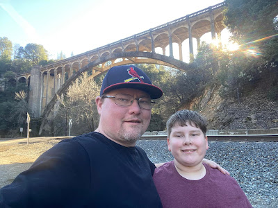
Above: Present day. L-R: Jeremy M. Tuggle and his son, Carson K. Tuggle, below the historic Harlan D. Miller Bridge along the railroad tracks near the confluence of the Sacramento River and Dog Creek. This photograph was taken January 21, 2022 by Jeremy Tuggle.
RESOURCES:
H.D Miller Is Named New Bridge Engineer - The Stockton Independent newspaper of Stockton, December 2, 1924
Napa Contractors Low Bridge Builders - The Healdsburg Tribune newspaper of Healdsburg, August 31, 1926
Two Highway Bridges Open Next Sunday - The Courier-Free Press newspaper of Redding, December 1, 1927
Blue Lake Advocate newspaper of Blue Lake, December 17, 1927
Harlan D. Miller Memorial Bridge by Charles E. Andrew - Western Construction News newsletter, page 47, December 25, 1927
Madera Tribune newspaper of Madera, December 29, 1927
Old Bridge written by Garth Sanders for the Record Searchlight newspaper, January 22, 1977
California Department of Transportation Library. McCurry Album Collection
The Sacramento River Canyon, SEC-E: 388, available at the Shasta Historical Society
Bridgehunter.com
That Ribbon Of Highway I: Highway 99 from the Oregon Border to the State Capital by Jill Livinston 1996 0-9651277-3-2 Second edition. Published by Living Gold Press. 212 Pages.
The historic Pollock bridge above the Sacramento River in 1936 with the town of Pollock in the distance on the north-east side of the Pollock bridge. From the collection of Jeremy Tuggle.
Above: where Pollock should be at the mouth of Salt Creek on the Sacramento River arm at 115.20-feet below the crest of Shasta Dam. Time to compare the ridge line of the mountains in the background with the first picture. This photo was taken by Jeremy Tuggle on June 11, 2021.
Above: a 1915-1945 map which predates the establishment of the townsite of Pollock at the junction of Salt Creek and the Sacramento River. This map shows the former alignment of the Central Pacific Railroad which was later acquired by Southern Pacific Railroad. It shows what was known as the Shasta Route on this map at that location. Source: CalTopo.
Pollock was formerly located along U.S. Route Highway 99 at the junction of Salt Creek and the Sacramento River. Today, Pollock is located just opposite of Sugarloaf Resort and Antler’s Marina on the Sacramento River arm at the mouth of Salt Creek under Lake Shasta. Construction on U.S. Route Highway 99 (also known as the Pacific Highway) began in California in 1914 and it was finished in 1922. During the interim years, a man named George G. Pollock, a native of Indiana, and a general contractor owned and operated the Pollock Construction Company, of Sacramento, which was awarded a contract from the California State Highway Commission in 1916 to construct a bridge which would span the Sacramento River at this location. The bridge was open for auto travel in February of 1917.
Later, a fire broke out on August 11, 1921, at Pollock “...which destroyed seven outfit cars sidetracked there, found that it was due to hoboes entering one of the cars and building a fire for cooking or keeping warm, and failure to extinguish it entirely when leaving.” (SIC) As Pollock was emerging into becoming a permanent fixture along the new highway, north state locals Davis & Robinson obtained a permit from the local railroad commission to operate an automobile passenger stage line from Redding to Sisson (now Mount Shasta City) in Siskiyou County. Along the route this stage line conveyed passengers to Pollock, Delta, La Moine, Hazel Creek, Castella and Dunsmuir. It promised weary travelers fast traveling times at cheap rates.
It was Redding resident Chris Kutras who purchased eighty acres on the east side of the Sacramento River near the highway bridge from landowner Mrs. N.S. Stillson on February 17, 1922. Kutras promised that this transaction would include the erection of a general grocery store, combination post office and service station building to be leased to H.L. Scott. Scott was slated to be the first postmaster of this U.S. Post Office, but he was bypassed by the officials in Washington D.C., for unknown reasons.
Then, on January 5, 1924, John Steinaker became the first postmaster of the brand-new United States Post Office at Pollock. The Pollock United States Post Office was established by the United States Postal Service in Washington D.C., and they named the post office after George G. Pollock. It was a fourth-class post office which served about 30 families residing at Pollock. However, Steinaker had leased his store’s building from Kutras, and it was in operation before July of 1923 without the post office, which began serving the area on January 5, 1924.
Above: a 1939 mineral deposit map of Shasta County surveyed by Charles V. Averill showing Pollock and the railroad.
Above: the combined Pollock Grocery Store, Post Office & Service Station at Pollock owned by Chris Kutras and leased to John Steinaker on the Sacramento River at Salt Creek. Date unknown. Courtesy of Shasta Historical Society.
Above: originally labeled as the Pollack Auto Camp. This is the Pollock Auto Camp at Pollock on the Sacramento River at Salt Creek. Date unknown. Courtesy of Shasta Historical Society.
As early as April of 1925, talk of a dam being built in the Sacramento River Canyon was already mentioned in statewide media coverage, and the Healdsburg Tribune of Healdsburg, reported the following about submerging the town of Pollock within in the future reservoir of what would become Shasta Lake by the construction of this dam in the following article:
"Would Create Lake In Shasta County
SACRAMENTO, April 10.- A dam in the Sacramento River canyon at the proposed Kennett site would submerge the towns of Kennett, Antler, Copper City and Pollock, twenty miles of the main line of the Southern Pacific, nine miles of the stale highway, two smelters, one mine and the state fish hatchery on the McCloud River. These consequences of the backing up of water in the Sacramento and Pit Rivers for thirty-two miles with a 400-foot dam are discussed by Paul Bailey, engineer who is making the survey of the state’s water resources begun in 1921, in his supplemental report on the work to date made to the present legislature."
Six years later, a brush fire erupted into flames two miles south of the town of Pollock in April of 1932 on the Kobe farm which resulted in the death of resident Mathew Kobe, age seventy-two, a native of Austria, and a local farmer. He had been fighting the fire when his trousers got caught in the flames and he jumped into Salt Creek to extinguish them. The flames caused serious burns upon his body, and in time, those burns were fatal to him. Kobe died on April 18, 1932, the decedent was survived by his wife, four sons and one daughter. The fire grew to two acres with no structure damage.
Beginning May 1st, of each year swimming at Salt Creek kicked off and even during the summer months Pollock residents were able to cool off in the creek which flowed year round. It would rise during rain storms. Much like today, even the local wildlife shared the running water of Salt Creek with their human neighbors.
Above: an article about Pollock happenings from the Courier-Free Press newspaper of Redding, dated: May 1, 1935, Pollock was a lively place along the Pacific Highway during the decade of the 1930s.
The town of Pollock was flooded during the historic Sacramento River flood of February 28, 1940, with winter storms flooding the river at that location, as Pollock got its first taste of being submerged in water. The flooding caused the Pollock bridge to be under six feet of water and at Woolman's store. The City of Redding was isolated in all directions which saw the traffic and the railroad trains stopped in all directions until the routes were passable a week later when the flood water lowered.
Four years later, on June 1, 1944, the Pollock United States post office was discontinued with Sarah Ann Moody being the last postmistress. Then it’s post office was relocated. The name of this United States post office was changed to Loftus in honor of Charles Loftus, a grandson of Mrs. Stella Woolman. The reason the Pollock United States post off was discontinued was due to the construction of Shasta Dam which threatened with submerging the town site into the reservoir of Shasta Lake (or Lake Shasta). Pollock would eventually become under the main water mark of the reservoir at full pool 1,067-feet elevation or distance from crest of Shasta Dam at 0-feet, with its 365 miles of shoreline. Lake Shasta began flooding its reservoir in 1942. Shasta Dam was engineered by Frank T. Crowe the owner of Pacific Constructors Incorporated, and construction began in 1938 and its construction was completed in 1945.
The Pollock townsite has surfaced during the drought years of 1976, 1977, 1991, 2008 and 2021 with portions of historic U.S. Route Highway 99 surfacing and the railroad of the Central Pacific built in 1884 and later acquired by the Southern Pacific Railroad this railroad was also known as the Shasta Route and traversed on the westside of the Sacramento River at Pollock. During these years, local Pollock relics included a 1916 cut and grade and a highway masonry wall with minimal foundations. The Pollock bridge is fully out of the water at 166.87-feet below the crest of Shasta Dam; and in the 1990's the resort that owned the bridge cut the bridge in half and repositioned it at an angle so they could start launching boats off of it during drought years, so not all of the bridge is intact. The Sacramento River arm at this location has changed drastically over the years. On July 11, 2021, the historic Pollock bridge began emerging out of the water at Lake Shasta for the first time in seven years at 131.15-feet below the crest of Shasta Dam.
POLLOCK POSTMASTERS:
John Steinaker - January 5, 1924
Mrs. Stella Klineschmidt - acting P.M. June 7, 1926, appointed June 10, 1926
Mrs. Stella Woolman (formerly Klineschmidt) - July 23, 1930
Mrs. Florence Mason - November 16, 1940
Mrs. Hazel N. Collins - April 23, 1942
Mrs. Sarah Ann Moody - December 1, 1942
Mrs. Sarah Ann Moody - June 1, 1943 - June 1, 1944.
Above: on top of the 1916 cut and grade (which is used for vehicle parking) on the north side of the Pollock bridge at Antler's Marina with historic U.S. Highway Route 99 below me. The Lake Shasta water level was 135.00-feet below the crest of Shasta Dam. This video was filmed on location July 16, 2021.
Above: at 148.45-feet below the crest of Shasta Dam the historic Highway Masonry Wall on Historic Route Highway 99 at Salt Creek is FULLY OUT of the water. This is at Pollock. A lot of Pollock history is discussed in this film. Filmed on location August 6, 2021.
Above: Portions of the historic railroad at Pollock surfacing out of the water at Shasta Lake. This is the railroad just north of the historic Pollock bridge. This video was filmed on location, September 4, 2021.
Above: the end of the Pollock bridge. The Pollock bridge is now full out of the water on 9-10-2021 at 900.13-feet elevation wise or 166.87-feet below the crest of Shasta Dam. This photograph was taken by Jeremy Tuggle.
Above: Jeremy Tuggle discovers a foundation of a building possibly connected to the Shasta Route Railroad at Pollock, just north of the historic Pollock bridge, at 891.58-feet elevation wise below full pool or 175.42-feet below the crest of Shasta Dam. Filmed on location on October 2, 2021 in Lakehead, California.
(Note: this article was featured in the October 2021, Shasta Historical Society Stagecoach newsletter, page 9, written by Jeremy Tuggle for the Shasta Historical Society.)
RESOURCES:
Canyon Roads Open For Automobiles - The Searchlight newspaper of Redding, February 16, 1917
Sacramento Canyon Open To Auto Travel - The Sacramento Daily Union newspaper of Sacramento, February 16, 1917
Road From Redding To Dunsmuir Finished - The Sacramento Daily Union newspaper of Sacramento, February 18, 1917
Marin Journal newspaper of San Rafael, April 12, 1917
1920 U.S. Census
The Searchlight newspaper of Redding, February 4, 1921
The Searchlight newspaper of Redding, August 21, 1921
The Searchlight newspaper of Redding, September 27, 1921
Stage Permit Granted - The Sacramento Daily Union newspaper of Sacramento, September 28, 1921
Pollock Will Have Post Office Store - The Courier-Free Press newspaper of Redding, February 17, 1922
Chris Kutras Buys 80 At Pollock - The Searchlight newspaper of Redding, February 17, 1922
The Searchlight newspaper of Redding, July 19, 1922
The Searchlight newspaper of Redding, April 7, 1923
Automobile Truck Had Five Million In Gold As Cargo - The Searchlight newspaper of Redding, May 29, 1923
Pollock Wants To Have A Post Office - The Searchlight newspaper of Redding, June 23, 1923
For Pollock - The Searchlight newspaper of Redding, July 10, 1923
Kennett-Pollock Road May Get State Money To Be Used As Detour - The Courier-Free Press newspaper of Redding, March 22, 1924
Would Create Lake In Shasta County - The Healdsburg Tribune of Healdsburg, April 10, 1925
Former Pollock Merchant Asks Divorce - The Searchlight newspaper of Redding, June 10, 1925
The Courier-Free Press newspaper of Redding, August 20, 1925
Folks You Know - The Courier-Free Press newspaper of Redding, January 23, 1932
Personal - The Courier-Free Press newspaper of Redding, February 9, 1932
Pollock Man's Death Blamed On Trousers - The Courier-Free Press newspaper of Redding, April 18, 1932
The Courier-Free Press newspaper of Redding, January 9, 1935
The Courier-Free Press newspaper of Redding, January 12, 1935
Pollock Woman Struck By Small Boy In Snowball - The Courier-Free Press newspaper of Redding, January 31, 1935
Camp Salt Creek Quarantine Lifted - The Courier-Free Press newspaper of Redding, February 7, 1935
Local Brevities - The Courier-Free Press newspaper of Redding, February 22, 1935
The Courier-Free Press newspaper of Redding, March 9, 1935
Highway Rerouting Is Studied - The Courier-Free Press newspaper of Redding, March 16, 1935
The Courier-Free Press newspaper of Redding, April 2, 1935
Pollock - The Courier-Free Press newspaper of Redding, April 8, 1935
Pollock - The Courier-Free Press newspaper of Redding, April 18, 1935
Pollock - The Courier-Free Press newspaper of Redding, April 20, 1935
Pollock - The Courier-Free Press newspaper of Redding, April 23, 1935
Pollock - The Courier-Free Press newspaper of Redding, April 27, 1935
Pollock - The Courier-Free Press newspaper of Redding, May 1, 1935
Pollock - The Courier-Free Press newspaper of Redding, May 8, 1935
Pollock Items - The Courier-Free Press newspaper of Redding, May 17, 1935
Pollock - The Courier-Free Press newspaper of Redding, May 18, 1935
Pollock - The Courier-Free Press newspaper of Redding, June 4, 1935
Pollock - The Courier-Free Press newspaper of Redding, June 11, 1935
Pollock - The Courier-Free Press newspaper of Redding, June 18, 1935
Pollock - The Courier-Free Press newspaper of Redding, July 9, 1935
The Courier-Free Press newspaper of Redding, August 12, 1935
Pollock Items - The Courier-Free Press newspaper of Redding, August 17, 1935
Pollock Items - The Courier-Free Press newspaper of Redding, August 22, 1935
Pollock Items - The Courier-Free Press newspaper of Redding, September 4, 1935
U.S., Appointments of U. S. Postmasters, 1832-1971
Redding Isolated - The Courier-Free Press newspaper of Redding, February 28, 1940
That Ribbon Of Highway I: Highway 99 from the Oregon Border to the State Capital by Jill Livinston 1996 0-9651277-3-2 Second edition. Published by Living Gold Press. 212 Pages.
HISTORIC U.S. ROUTE HIGHWAY 99 AT TURNTABLE BAY AT SHASTA LAKE, 9-12-2021. AS OF TODAY, SHASTA LAKE IS 899.30-FEET ELEVATION WISE OR 167.70-FEET BELOW THE CREST OF SHASTA DAM AND IT IS 25% FULL.
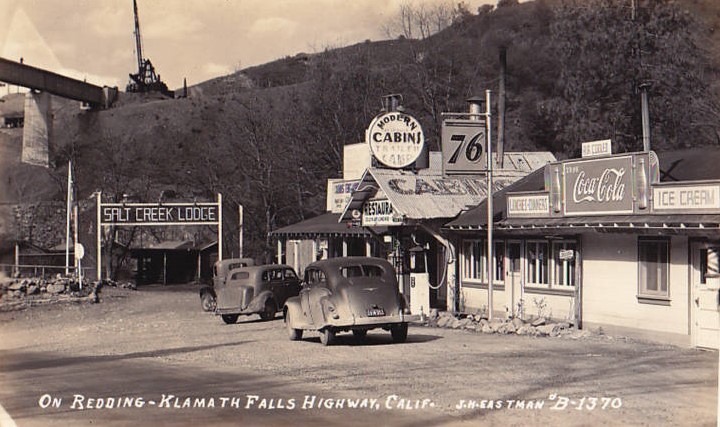
A friend of mine sent me this wonderful image which is titled, “On Redding-Klamath Falls Highway, Calif.”. It’s a photograph captured in the late 1930s by J.H. Eastman, a local photographer when he was at Salt Creek, now part of present day Lake Shasta or Shasta Lake. The highway route is actually historic U.S. Route Highway 99. It’s still there today on Lower Salt Creek Road in the Sacramento River Canyon. Thank you, David for the intriguing postcard!

 Posts
Posts