

2 historic cable support iron mooring pins appear in this video which belong to Waugh’s Ferry are embedded into the ground here at this location along the Sacramento River Trail system south of the mouth of Rock Creek and north of the present-day Ribbon Bridge and on the west side of the Sacramento River. One of them is hidden in plain site on the trail, perhaps you have noticed it before, or perhaps not? This one that is shown as the cover photo to this video is definitely the oldest one of the two blacksmith forged cable support iron mooring pins which held the cable to Waugh’s Ferry. This ferry was owned and operated by a pioneer ferryman named Joseph Waugh a local resident of the town which bore his surname near the ferry site. Waugh strung up 750 feet of cable which spanned the Sacramento River on both the west side and east side so it would stronghold the ferry against the current of the Sacramento River as it transported passengers and freight across the river on this watercraft. Click play to enjoy the video. This is a follow up to my last YouTube video I did on this subject called The Remaining Historic Relics at Waugh's Ferry and the Townsite of Waugh at Middle Creek. You can find my resources for this video at the above link.
Subscribe To
Tuesday, February 28, 2023
Saturday, February 25, 2023
The Remaining Historic Relics at Waugh's Ferry and the Townsite of Waugh at Middle Creek
Place Names of Shasta County by Gertrude A. Steger revision by Helen Hinckley Jones, ©1966 by La Siesta Press, Glendale, California
Thursday, December 22, 2022
19th Century Wagon Ruts Along the Sacramento River Trail Near Waugh.
In 1883 the construction of the Shasta to Middle Creek Road was completed which was also known as Middle Creek Road, and alias the River Road, which connected Shasta with the townsite of Waugh. Four years later, in 1887 construction resumed on this route which brought the road into Redding from the mouth of Middle Creek on the west bank of the Sacramento River heading south into Redding. Most of it was situated along present-day Sacramento River Trail with parts still in existence today. Wagon ruts are pretty rare and exciting to find when you locate them unexpectedly. They appear on well-traveled routes in the region like this route here which date to the 19th Century.
Resources:
Pacific Coast Items - The Sacramento Daily Union newspaper of Sacramento, May 19, 1883
Our Neighbors - The Humboldt Times newspaper of Eureka, May 20, 1883
Our Neighbors - The Humboldt Times newspaper of Eureka, June 5, 1883
Shasta: The Queen City by Mabel Moores Frisbie and Jean Moores Beauchamp, published by California Historical Society, ©1973.
Sunday, November 13, 2022
Hand Carved Sandstone Blocks Along The Present-Day, Sacramento River Trail.


Friday, April 2, 2021
The Sky Blue mine

RESOURCES:
Sky Blue Ledge Company - The Shasta Courier newspaper of Shasta, April 11, 1863
Tuesday, August 14, 2018
MAJOR PIERSON BARTON READING (1816-1868): THE FIRST EUROPEAN-AMERICAN SETTLER IN SHASTA COUNTY


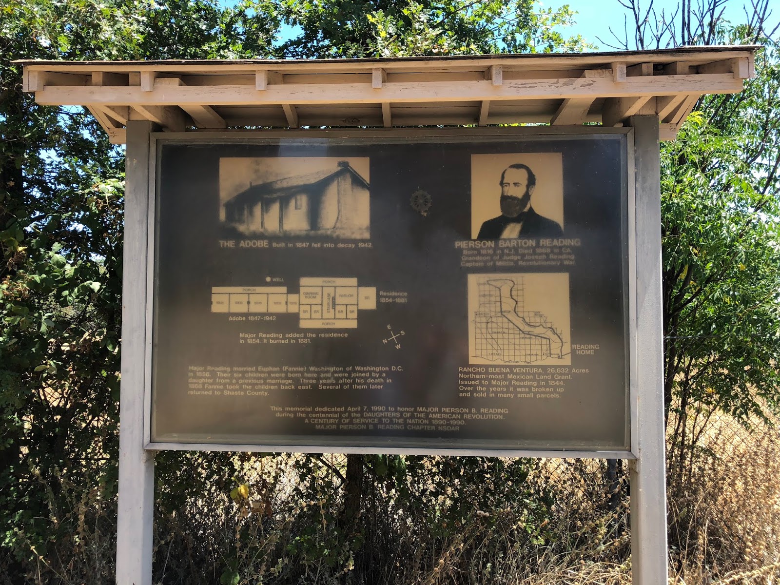


RP-004 - Reading, Pierson Barton Pioneer Plaque File on file at Shasta Historical Society.
Death of Major Reading - The Shasta Courier newspaper of Shasta, May 30, 1868
Died - The Shasta Courier newspaper of Shasta, May 30, 1868
Funeral - The Shasta Courier newspaper of Shasta, June 6, 1868
Pioneer Woman Called Beyond At Washington - The Courier-Free Press newspaper of Redding, May 6, 1918
An E-mail Correspondence - Subject: Jeanette Reading dated August 9, 2018 between David L. Templeman and Jeremy M. Tuggle, filed in the RP-004 Reading, Pierson Barton Pioneer Plaque File on file at Shasta Historical Society.
Tuesday, July 24, 2018
The Bunker Hill Mine


Above: The superintendent of the mine more than likely lived near this plugged water well of the Bunker Hill mine. This photograph was taken by Jeremy Tuggle on June 13, 2015.

Above: One of the plugged shafts of the Bunker Hill mine. This photograph was taken by Jeremy Tuggle on June 13, 2015.


Above: The headstone of the original locator of the Bunker Hill mine, Samuel Gaston (1834-1909). He was interred into the Redding Memorial Park. Gaston was a native of Livingston County, New York. He arrived in Shasta County and settled at Middle Creek in 1852. He was a miner. At a later date, Gaston relocated from Middle Creek to Elko, Nevada where he served as a deputy Sheriff for a number of years. After that, he returned to Shasta County and died in the county hospital. This photograph was taken by Jeremy Tuggle on June 19, 2018.