

I've blogged about these former historical highway features before called C-Block markers which were once a prominent feature along state highways. This hidden C-Block marker is located along Shasta Dam Boulevard also known as California State Route 151, near Shasta Dam. Find out more in this short video below. Filmed on location 1-28-2023.
Subscribe To
Showing posts with label California Department of Transportation. Show all posts
Showing posts with label California Department of Transportation. Show all posts
Sunday, January 29, 2023
Thursday, January 27, 2022
THE HARLAN D. MILLER MEMORIAL BRIDGE AT DOG CREEK

Above: this sepia image captured the wooden falsework on the completed Dog Creek bridge. Year: 1927. Photographer unknown. From the collection of Jeremy Tuggle.
In 1926, a general engineer named Charles E. Andrew began the construction on the brand-new 234-foot open spandrel arch shaped Dog Creek bridge which is located in the Sacramento River Canyon, 30 miles north of Redding at Dog Creek, and just east of present-day Interstate 5. This bridge was designed by a general engineer named Harlan D. Miller, of Oakland, who was the State Bridge Engineer for the California Division of Highways from 1923 until he died while maintaining that position in 1926. Miller is also credited with designing the open spandrel arch shaped Charlie Creek and Doney Creek bridges in Lakehead.

Above: this sepia image captured the Route Highway 99 traversing through the canyon with the Dog Creek bridge under construction. Year: 1927. Photographer unknown. From the collection of Jeremy Tuggle.
When the Dog Creek bridge construction was completed it connected motorists with U.S. Route Highway 99 (also known as the Pacific Highway) spanning Dog Creek Canyon as a two-lane bridge for $123,000, despite original reports stating that it could be built for $110,000. The Dog Creek bridge was opened for public transportation on December 4, 1927, and its services were suspended thirty-years later in 1957. During 1957 a brand-new four-lane north and south bound bridge span connected motorists with Interstate 5 which was built an eighth of a mile west of the Dog Creek bridge. Before the four-lane bridge was built it was planned, that year, for the north bound traffic to utilize the Dog Creek bridge and have the south bound traffic utilize the brand-new bridge but that changed before the four-lane bridge was completed and the Dog Creek bridge became abandoned.
In 1927, the California Division of Highways dedicated the Dog Creek bridge to the memory of Harlan D. Miller. Later on, in 1974 a resolution was passed by the California Legislature that officially changed the name of this historic bridge to the Harlan D. Miller Memorial bridge. For many years, this historic bridge was scheduled to be dynamited by the California Department of Transportation (Caltrans) and then in 1977 the bureaucrats in Sacramento wanted it dynamited as well. Yet, this bridge was saved from being dynamited that year. Presently, this bridge is protected by Federal law and it was designated as a California Historical Landmark on May 29, 1984. The bridge is still intact and visible today.

Above: a sepia image of an open span aerial view of the Dog Creek bridge. Year: 1927. Photographer unknown. From the collection of Jeremy Tuggle.
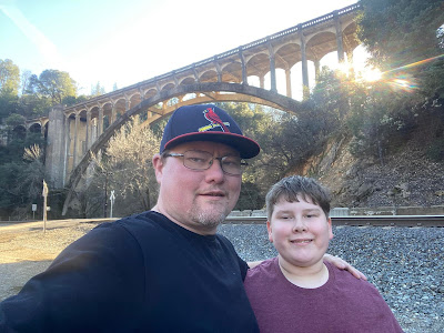
Above: Present day. L-R: Jeremy M. Tuggle and his son, Carson K. Tuggle, below the historic Harlan D. Miller Bridge along the railroad tracks near the confluence of the Sacramento River and Dog Creek. This photograph was taken January 21, 2022 by Jeremy Tuggle.
RESOURCES:
H.D Miller Is Named New Bridge Engineer - The Stockton Independent newspaper of Stockton, December 2, 1924
Napa Contractors Low Bridge Builders - The Healdsburg Tribune newspaper of Healdsburg, August 31, 1926
Two Highway Bridges Open Next Sunday - The Courier-Free Press newspaper of Redding, December 1, 1927
Blue Lake Advocate newspaper of Blue Lake, December 17, 1927
Harlan D. Miller Memorial Bridge by Charles E. Andrew - Western Construction News newsletter, page 47, December 25, 1927
Madera Tribune newspaper of Madera, December 29, 1927
Old Bridge written by Garth Sanders for the Record Searchlight newspaper, January 22, 1977
California Department of Transportation Library. McCurry Album Collection
The Sacramento River Canyon, SEC-E: 388, available at the Shasta Historical Society
Bridgehunter.com
That Ribbon Of Highway I: Highway 99 from the Oregon Border to the State Capital by Jill Livinston 1996 0-9651277-3-2 Second edition. Published by Living Gold Press. 212 Pages.
Thursday, June 14, 2018
C-Block Markers

This C-Block Marker is located along 299 East just above Montgomery Creek about 43.1 miles from Redding. This photo was taken March 16, 2016 by Jeremy Tuggle.
These concrete markers were once a regular feature of the highway system in California and they were used to mark the right-of-ways along the various highways. They were also used as survey monuments. They are called C-Block Markers and they were placed along the highways in the state by the California Division of Highways between 1914 and 1934.
The California Division of Highways managed our state highways as early as 1912. It was the predecessor of the California Department of Transportation (CalTrans). They stopped placing these in 1934. Today, CalTrans and other agencies still use C-Block Markers to help them survey the highways.

This C-Block Marker is located in Shasta Lake City. Park on Union School Road just east of the overpass and walk back over to the west side, trail starts to the north over the guardrail. This photograph was taken by Jeremy Tuggle on May 27, 2017.
Subscribe to:
Posts (Atom)